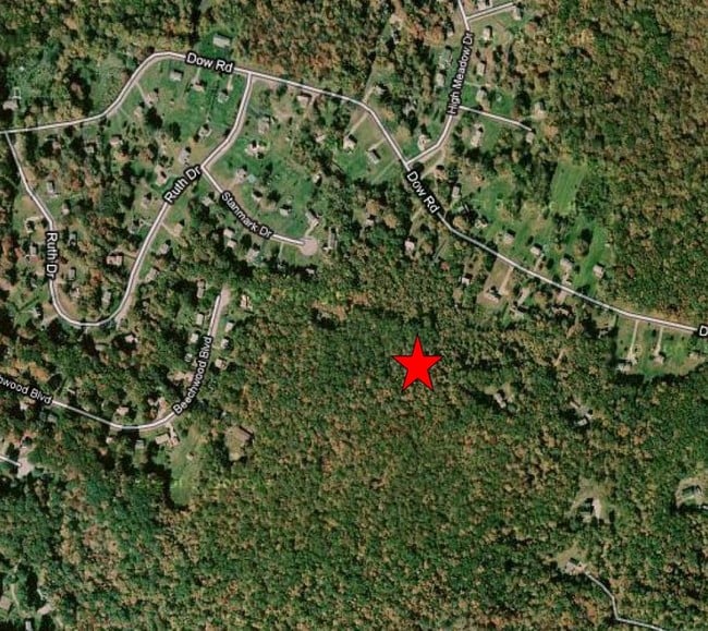
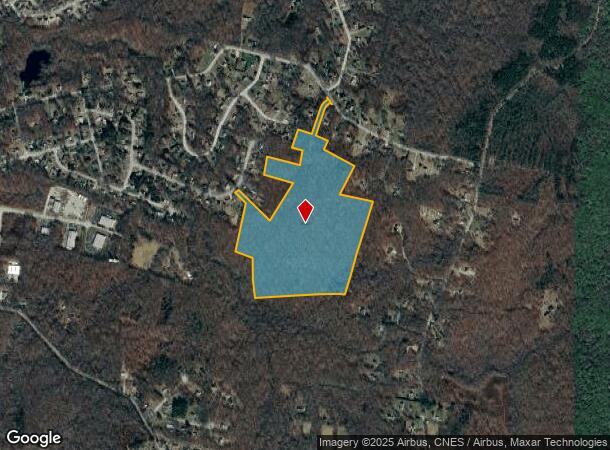
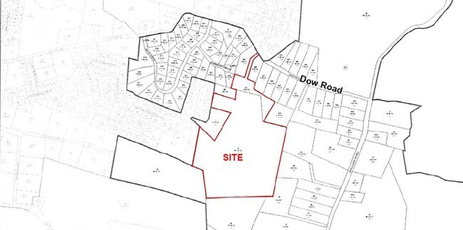
Property Record
Beechwood Blvd, Plainfield, CT 06374
NEARBY LISTINGS FOR SALE OR LEASE
Property Detail
Beechwood Blvd
PLAI-000026-000011-000006
Windham
Residentialacreage
Connecticut
X
6
09015C0370F
44.85 AC
2024
Windham County
2025
Hartford
907300
Willimantic, CT
DEMOGRAPHICS near Beechwood Blvd
1 mile
3 mile
5 mile
2024 Total Population
1,374
7,648
18,019
2029 Population
1,378
7,631
17,872
Pop Growth 2024-2029
+ 0.29%
(0.22%)
(0.82%)
Average Age
40
42
41
2024 Total Households
498
2,960
7,100
HH Growth 2024-2029
+ 0.40%
(0.27%)
(0.80%)
Median Household Inc
$70,904
$67,826
$72,770
Avg Household Size
2.60
2.50
2.50
2024 Avg HH Vehicles
2.00
2.00
2.00
Median Home Value
$258,793
$216,773
$237,203
Median Year Built
1982
1971
1971
Nearby Places
Map Layers
Map Styles
 Street
 Aerial
Transit
 Traffic
 Biking
Places
Listings with unknown addresses are not visible on the map
- Restaurants
- Banks
- Shops
- Fitness
- Groceries
PUBLIC TRANSPORTATION
AIRPORT
Rhode Island Tf Green International
Drive
Walk
Distance
Rhode Island Tf Green International
57 min
40.1 mi
Freight Ports
Port of Davisville, RI
Drive
Walk
Distance
Port of Davisville, RI
67 min
35.8 mi
Nearby Properties
Address
Land Use
TOTAL SIZE
Lot Size
Zoning
Address
Land Use
TOTAL SIZE
Lot Size
Zoning
202.19 AC
IND
Address
Land Use
TOTAL SIZE
Lot Size
Zoning
202,044 SF
52.20 AC
I
Address
Land Use
TOTAL SIZE
Lot Size
Zoning
37.12 AC
RA60
Address
Land Use
TOTAL SIZE
Lot Size
Zoning
54,304 SF
28.41 AC
IND-2
Address
Land Use
TOTAL SIZE
Lot Size
Zoning
13,444 SF
10.94 AC
RA30
Address
Land Use
TOTAL SIZE
Lot Size
Zoning
27,400 SF
4.34 AC
C2
Address
Land Use
TOTAL SIZE
Lot Size
Zoning
15.20 AC
C
Address
Land Use
TOTAL SIZE
Lot Size
Zoning
2,836 SF
139.54 AC
I
Address
Land Use
TOTAL SIZE
Lot Size
Zoning
35,165 SF
6.63 AC
RA30
Address
Land Use
TOTAL SIZE
Lot Size
Zoning
6.26 AC
C
Address
Land Use
TOTAL SIZE
Lot Size
Zoning
Address
Land Use
TOTAL SIZE
Lot Size
Zoning
34,830 SF
2.52 AC
C2
Address
Land Use
TOTAL SIZE
Lot Size
Zoning
80,180 SF
9.66 AC
IND-1
Address
Land Use
TOTAL SIZE
Lot Size
Zoning
10,937 SF
2.54 AC
C2
Address
Land Use
TOTAL SIZE
Lot Size
Zoning
11.40 AC
CI
Address
Land Use
TOTAL SIZE
Lot Size
Zoning
28,494 SF
6.67 AC
C2
Address
Land Use
TOTAL SIZE
Lot Size
Zoning
8.30 AC
RA30
Address
Land Use
TOTAL SIZE
Lot Size
Zoning
13,812 SF
1.70 AC
RA19
Address
Land Use
TOTAL SIZE
Lot Size
Zoning
26,796 SF
2.89 AC
I
Address
Land Use
TOTAL SIZE
Lot Size
Zoning
18,600 SF
2.50 AC
RA19
Address
Land Use
TOTAL SIZE
Lot Size
Zoning
12,692 SF
2.46 AC
C2
Address
Land Use
TOTAL SIZE
Lot Size
Zoning
52.63 AC
IND-1
Address
Land Use
TOTAL SIZE
Lot Size
Zoning
10,000 SF
6.25 AC
IND
Address
Land Use
TOTAL SIZE
Lot Size
Zoning
6,889 SF
1.04 AC
C
Address
Land Use
TOTAL SIZE
Lot Size
Zoning
27,060 SF
2.76 AC
C2
Address
Land Use
TOTAL SIZE
Lot Size
Zoning
44.90 AC
I
Address
Land Use
TOTAL SIZE
Lot Size
Zoning
1,642 SF
3.14 AC
RA30
Address
Land Use
TOTAL SIZE
Lot Size
Zoning
0.23 AC
IP
Address
Land Use
TOTAL SIZE
Lot Size
Zoning
29,640 SF
2.72 AC
RA60
Address
Land Use
TOTAL SIZE
Lot Size
Zoning
29,447 SF
2.50 AC
C
The World's #1 Commercial Real Estate Marketplace
Connect with us
© 2026 CoStar Group
The information above has been obtained from sources believed reliable. While we do not doubt its accuracy we have not verified it and make no guarantee, warranty or representation about it. It is your responsibility to independently confirm its accuracy and completeness. Any projections, opinions, assumptions, or estimates used are for example only and do not represent the current or future performance of the property. The value of this transaction to you depends on tax and other factors which should be evaluated by your tax, financial, and legal advisors. You and your advisors should conduct a careful, independent investigation of the property to determine to your satisfaction the suitability of the property for your needs.