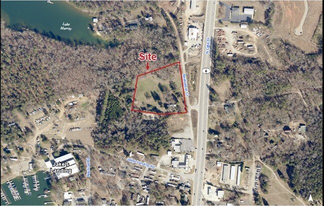
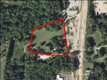
Property Record
Beekeeper Ct, Lexington, SC 29072

NEARBY LISTINGS FOR SALE OR LEASE
Property Detail
Beekeeper Ct
003418-01-002
Prepared For G Willard Wingard
Sfr
Lexington
X
South Carolina
45063C0138J
4.18 AC
2025
Lexington
2024
Columbia
021050
Columbia, SC
1,154 SF
DEMOGRAPHICS near Beekeeper Ct
1 mile
3 mile
5 mile
2024 Total Population
1,141
26,150
82,659
2029 Population
1,247
28,479
89,743
Pop Growth 2024-2029
+ 9.29%
+ 8.91%
+ 8.57%
Average Age
42
42
41
2024 Total Households
424
10,173
33,010
HH Growth 2024-2029
+ 9.43%
+ 9.11%
+ 8.78%
Median Household Inc
$114,015
$96,900
$79,164
Avg Household Size
2.60
2.50
2.40
2024 Avg HH Vehicles
2.00
2.00
2.00
Median Home Value
$419,047
$268,157
$233,331
Median Year Built
1998
1997
1993
Nearby Places
Map Layers
Map Styles
 Street
 Aerial
Transit
 Traffic
 Biking
Places
Listings with unknown addresses are not visible on the map
- Restaurants
- Banks
- Shops
- Fitness
- Groceries
PUBLIC TRANSPORTATION
AIRPORT
Columbia Metro
Drive
Walk
Distance
Columbia Metro
31 min
15.7 mi
Freight Ports
North Charleston Terminal
Drive
Walk
Distance
North Charleston Terminal
130 min
112.0 mi
SALE & LEASE HISTORY
LISTING DATE
SALE/LEASE

Sep 24, 2016
For Sale
Jan 21, 2021
For Sale
Nearby Properties
Address
Land Use
TOTAL SIZE
Lot Size
Zoning
Address
Land Use
TOTAL SIZE
Lot Size
Zoning
23,208 SF
31.18 AC
C2
Address
Land Use
TOTAL SIZE
Lot Size
Zoning
1,485 SF
19.51 AC
GC
Address
Land Use
TOTAL SIZE
Lot Size
Zoning
63,658 SF
17.56 AC
GC
Address
Land Use
TOTAL SIZE
Lot Size
Zoning
29,046 SF
12.29 AC
C2
Address
Land Use
TOTAL SIZE
Lot Size
Zoning
38,496 SF
19.41 AC
HDR
Address
Land Use
TOTAL SIZE
Lot Size
Zoning
3,406 SF
19.99 AC
HDR
Address
Land Use
TOTAL SIZE
Lot Size
Zoning
204,927 SF
24.82 AC
GC
Address
Land Use
TOTAL SIZE
Lot Size
Zoning
78,131 SF
24 AC
GC
Address
Land Use
TOTAL SIZE
Lot Size
Zoning
39,713 SF
11.70 AC
GC
Address
Land Use
TOTAL SIZE
Lot Size
Zoning
86,935 SF
9.91 AC
ID
Address
Land Use
TOTAL SIZE
Lot Size
Zoning
64,281 SF
11.71 AC
GC
Address
Land Use
TOTAL SIZE
Lot Size
Zoning
79,246 SF
9.04 AC
GC
Address
Land Use
TOTAL SIZE
Lot Size
Zoning
2,065 SF
19.73 AC
HDR
Address
Land Use
TOTAL SIZE
Lot Size
Zoning
85,600 SF
22.08 AC
Address
Land Use
TOTAL SIZE
Lot Size
Zoning
136,940 SF
20.36 AC
GC
Address
Land Use
TOTAL SIZE
Lot Size
Zoning
102,553 SF
13.30 AC
GC
Address
Land Use
TOTAL SIZE
Lot Size
Zoning
127,329 SF
10.91 AC
Address
Land Use
TOTAL SIZE
Lot Size
Zoning
85,508 SF
9.22 AC
GC
Address
Land Use
TOTAL SIZE
Lot Size
Zoning
62,141 SF
7.28 AC
GC
Address
Land Use
TOTAL SIZE
Lot Size
Zoning
37,404 SF
9.32 AC
Address
Land Use
TOTAL SIZE
Lot Size
Zoning
2,254 SF
0.16 AC
RD
Address
Land Use
TOTAL SIZE
Lot Size
Zoning
51,657 SF
3.48 AC
ID
Address
Land Use
TOTAL SIZE
Lot Size
Zoning
33,218 SF
4.40 AC
GC
Address
Land Use
TOTAL SIZE
Lot Size
Zoning
14,820 SF
2.56 AC
Address
Land Use
TOTAL SIZE
Lot Size
Zoning
2,289 SF
0.16 AC
RD
Address
Land Use
TOTAL SIZE
Lot Size
Zoning
1,911 SF
0.16 AC
RD
Address
Land Use
TOTAL SIZE
Lot Size
Zoning
35,109 SF
11.06 AC
GC
Address
Land Use
TOTAL SIZE
Lot Size
Zoning
2,253 SF
0.16 AC
RD
Address
Land Use
TOTAL SIZE
Lot Size
Zoning
1,296 SF
32.15 AC
ID
Address
Land Use
TOTAL SIZE
Lot Size
Zoning
4,088 SF
1.05 AC
RD
The World's #1 Commercial Real Estate Marketplace
Connect with us
© 2026 CoStar Group
The information above has been obtained from sources believed reliable. While we do not doubt its accuracy we have not verified it and make no guarantee, warranty or representation about it. It is your responsibility to independently confirm its accuracy and completeness. Any projections, opinions, assumptions, or estimates used are for example only and do not represent the current or future performance of the property. The value of this transaction to you depends on tax and other factors which should be evaluated by your tax, financial, and legal advisors. You and your advisors should conduct a careful, independent investigation of the property to determine to your satisfaction the suitability of the property for your needs.