Property Record
3157 N Highway 17, Mount Pleasant, SC 29466
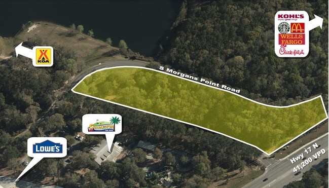

Property Detail
3157 N Highway 17
600-00-00-024
MAPPLATB L24 MAPPLATP 0325 SUBDIVISIONNAME MT PLEASANT LOT PARCEL B
Commercialnec
Charleston
AE The base floodplain where base flood elevations are provided. AE Zones are now used on new format FIRMs instead of A1-A30 Zones.
South Carolina
2025
33.41 AC
2024
East Islands/Mt Pleasant
004609
Charleston/N Charleston
1,600 SF
Charleston-North Charleston, SC
NEARBY LISTINGS FOR SALE OR LEASE
DEMOGRAPHICS near 3157 N Highway 17
1 mile
3 mile
5 mile
2025 Total Population
5,083
32,510
64,389
2030 Population
5,173
33,679
66,921
Pop Growth 2025-2030
+ 1.77%
+ 3.60%
+ 3.93%
Average Age
42
42
43
2025 Total Households
2,059
12,180
25,137
HH Growth 2025-2030
+ 1.75%
+ 3.60%
+ 3.95%
Median Household Inc
$89,694
$121,815
$124,580
Avg Household Size
2.40
2.60
2.50
2025 Avg HH Vehicles
2.00
2.00
2.00
Median Home Value
$575,138
$707,534
$746,267
Median Year Built
2004
2004
2000
Nearby Places
Map Layers
Map Styles
 Street
 Aerial
Layers
 Traffic
 Biking
Places
Listings with unknown addresses are not visible on the map
- Restaurants
- Banks
- Shops
- Fitness
- Groceries
PUBLIC TRANSPORTATION
AIRPORT
Charleston AFB/International
Drive
Walk
Distance
Charleston AFB/International
35 min
22.4 mi
Freight Ports
Wando Welch Terminal
Drive
Walk
Distance
Wando Welch Terminal
14 min
7.1 mi
SALE & LEASE HISTORY
LISTING DATE
SALE/LEASE

Aug 01, 2019
For Lease
Nearby Properties
Address
Land Use
TOTAL SIZE
Lot Size
Zoning
Address
Land Use
TOTAL SIZE
Lot Size
Zoning
19.70 AC
Address
Land Use
TOTAL SIZE
Lot Size
Zoning
20.24 AC
Address
Land Use
TOTAL SIZE
Lot Size
Zoning
Address
Land Use
TOTAL SIZE
Lot Size
Zoning
10,948 SF
1.94 AC
Address
Land Use
TOTAL SIZE
Lot Size
Zoning
24,836 SF
10.63 AC
Address
Land Use
TOTAL SIZE
Lot Size
Zoning
9.11 AC
Address
Land Use
TOTAL SIZE
Lot Size
Zoning
Address
Land Use
TOTAL SIZE
Lot Size
Zoning
6,622 SF
20.06 AC
Address
Land Use
TOTAL SIZE
Lot Size
Zoning
3.76 AC
Address
Land Use
TOTAL SIZE
Lot Size
Zoning
2,646 SF
16.35 AC
Address
Land Use
TOTAL SIZE
Lot Size
Zoning
Address
Land Use
TOTAL SIZE
Lot Size
Zoning
Address
Land Use
TOTAL SIZE
Lot Size
Zoning
Address
Land Use
TOTAL SIZE
Lot Size
Zoning
Address
Land Use
TOTAL SIZE
Lot Size
Zoning
1,104 SF
13.70 AC
Address
Land Use
TOTAL SIZE
Lot Size
Zoning
5,209 SF
5.88 AC
Address
Land Use
TOTAL SIZE
Lot Size
Zoning
864 SF
22.36 AC
Address
Land Use
TOTAL SIZE
Lot Size
Zoning
Address
Land Use
TOTAL SIZE
Lot Size
Zoning
12.60 AC
Address
Land Use
TOTAL SIZE
Lot Size
Zoning
30,495 SF
8.73 AC
Address
Land Use
TOTAL SIZE
Lot Size
Zoning
45,969 SF
10.76 AC
Address
Land Use
TOTAL SIZE
Lot Size
Zoning
Address
Land Use
TOTAL SIZE
Lot Size
Zoning
Address
Land Use
TOTAL SIZE
Lot Size
Zoning
Address
Land Use
TOTAL SIZE
Lot Size
Zoning
9.81 AC
Address
Land Use
TOTAL SIZE
Lot Size
Zoning
38,788 SF
10.28 AC
Address
Land Use
TOTAL SIZE
Lot Size
Zoning
Address
Land Use
TOTAL SIZE
Lot Size
Zoning
1,910 SF
7.59 AC
Address
Land Use
TOTAL SIZE
Lot Size
Zoning
8,080 SF
8.82 AC
Address
Land Use
TOTAL SIZE
Lot Size
Zoning
The World's #1 Commercial Real Estate Marketplace
Connect with us
© 2026 CoStar Group
The information above has been obtained from sources believed reliable. While we do not doubt its accuracy we have not verified it and make no guarantee, warranty or representation about it. It is your responsibility to independently confirm its accuracy and completeness. Any projections, opinions, assumptions, or estimates used are for example only and do not represent the current or future performance of the property. The value of this transaction to you depends on tax and other factors which should be evaluated by your tax, financial, and legal advisors. You and your advisors should conduct a careful, independent investigation of the property to determine to your satisfaction the suitability of the property for your needs.