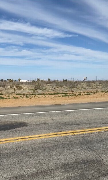
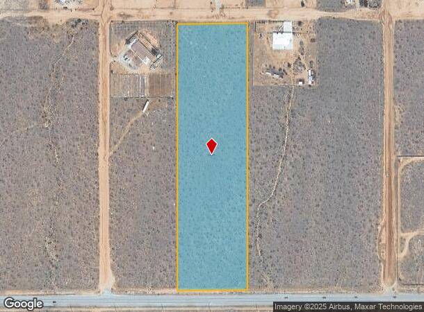
Property Record
Begonia Rd, Phelan, CA 92371
NEARBY LISTINGS FOR SALE OR LEASE
Property Detail
Begonia Rd
Riverside-San Bernardino-Ontario, CA
06W
3102-351-06
E 1/2 W 1/2 SE 1/4 NE 1/4 SEC 21 TP 5N R 6W EX 1/2 MNL RTS EX HWY
Vacantlandnec
San Bernardino
D
California
06071C5775H
21
2024
9.25 AC
2025
Mojave River Valley
009123
Inland Empire (California)
DEMOGRAPHICS near Begonia Rd
1 Mile
3 Mile
5 Mile
2024 Total Population
619
2,547
21,272
2029 Population
628
2,540
21,429
Pop Growth 2024-2029
+ 1.45%
(0.27%)
+ 0.74%
Average Age
37
38
35
2024 Total Households
93
586
5,066
HH Growth 2024-2029
+ 2.15%
(0.68%)
+ 0.65%
Median Household Inc
$60,682
$62,913
$71,277
Avg Household Size
3.50
3.20
3.50
2024 Avg HH Vehicles
2.00
3.00
3.00
Median Home Value
$277,777
$303,302
$296,473
Median Year Built
1995
1993
1996
Nearby Places
Map Layers
Map Styles
 Street
 Aerial
- Restaurants
- Banks
- Shops
- Fitness
- Groceries
SALE & LEASE HISTORY
LISTING DATE
SALE/LEASE

Mar 27, 2020
For Sale
Nearby Properties
Address
Land Use
TOTAL SIZE
Lot Size
Zoning
Address
Land Use
TOTAL SIZE
Lot Size
Zoning
Address
Land Use
TOTAL SIZE
Lot Size
Zoning
80 AC
Address
Land Use
TOTAL SIZE
Lot Size
Zoning
9,600 SF
2.04 AC
Address
Land Use
TOTAL SIZE
Lot Size
Zoning
17.60 AC
SDCOM
Address
Land Use
TOTAL SIZE
Lot Size
Zoning
10 AC
PHSDCOM
Address
Land Use
TOTAL SIZE
Lot Size
Zoning
20 AC
RL10
Address
Land Use
TOTAL SIZE
Lot Size
Zoning
9.81 AC
Address
Land Use
TOTAL SIZE
Lot Size
Zoning
77.57 AC
PHRL
Address
Land Use
TOTAL SIZE
Lot Size
Zoning
80 AC
PHRL
Address
Land Use
TOTAL SIZE
Lot Size
Zoning
40 AC
Address
Land Use
TOTAL SIZE
Lot Size
Zoning
20 AC
PHSDCOM
Address
Land Use
TOTAL SIZE
Lot Size
Zoning
30 AC
Address
Land Use
TOTAL SIZE
Lot Size
Zoning
9.14 AC
SDCOM
Address
Land Use
TOTAL SIZE
Lot Size
Zoning
8.66 AC
PHSDCOM
Address
Land Use
TOTAL SIZE
Lot Size
Zoning
40 AC
RL
Address
Land Use
TOTAL SIZE
Lot Size
Zoning
40 AC
RL
Address
Land Use
TOTAL SIZE
Lot Size
Zoning
8,000 SF
9 AC
Address
Land Use
TOTAL SIZE
Lot Size
Zoning
36.29 AC
PHRL
Address
Land Use
TOTAL SIZE
Lot Size
Zoning
37.10 AC
PHRL
Address
Land Use
TOTAL SIZE
Lot Size
Zoning
53.90 AC
PHRL
Address
Land Use
TOTAL SIZE
Lot Size
Zoning
35 AC
RL
Address
Land Use
TOTAL SIZE
Lot Size
Zoning
37.13 AC
PHRL
Address
Land Use
TOTAL SIZE
Lot Size
Zoning
19.24 AC
PHRL
Address
Land Use
TOTAL SIZE
Lot Size
Zoning
11 AC
PHSDCOM
The World's #1 Commercial Real Estate Marketplace
Connect with us
© 2025 CoStar Group
The information above has been obtained from sources believed reliable. While we do not doubt its accuracy we have not verified it and make no guarantee, warranty or representation about it. It is your responsibility to independently confirm its accuracy and completeness. Any projections, opinions, assumptions, or estimates used are for example only and do not represent the current or future performance of the property. The value of this transaction to you depends on tax and other factors which should be evaluated by your tax, financial, and legal advisors. You and your advisors should conduct a careful, independent investigation of the property to determine to your satisfaction the suitability of the property for your needs.