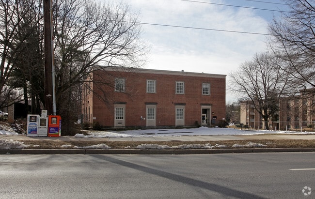
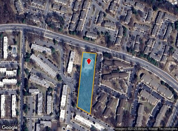
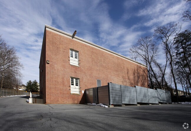
Property Record
Bel Pre Rd, , MD
NEARBY LISTINGS FOR SALE OR LEASE
-
-
View all listings for sale on LoopNet.com
Property Detail
Bel Pre Rd
Washington-Arlington-Alexandria, DC-VA-MD-WV
Clouin Course & Dublin Farm
13-00956400
PLAT 8459 PARCEL A B EL PRE DIAL CENTER
Transportationcommunicationsgeneral
Montgomery
X
Maryland
24031C0355D
2 AC
2024
Kensington/Wheaton
2025
Washington, DC
703213
DEMOGRAPHICS near Bel Pre Rd
1 Mile
3 Mile
5 Mile
2024 Total Population
25,164
123,014
299,467
2029 Population
25,029
121,350
296,075
Pop Growth 2024-2029
(0.54%)
(1.35%)
(1.13%)
Average Age
45
42
41
2024 Total Households
10,246
42,067
108,922
HH Growth 2024-2029
(0.49%)
(1.36%)
(1.16%)
Median Household Inc
$62,968
$94,442
$107,360
Avg Household Size
2.40
2.80
2.60
2024 Avg HH Vehicles
1.00
2.00
2.00
Median Home Value
$273,325
$428,281
$493,040
Median Year Built
1978
1972
1975
Nearby Places
Map Layers
Map Styles
 Street
 Aerial
- Restaurants
- Banks
- Shops
- Fitness
- Groceries
PUBLIC TRANSPORTATION
COMMUTER RAIL
Rockville (Brunswick Line - Maryland Area Regional Commuter Trains (The MARC))
DRIVE
WALK
Distance
Rockville (Brunswick Line - Maryland Area Regional Commuter Trains (The MARC))
11 min
4.5 mi
Kensington (Brunswick Line - Maryland Area Regional Commuter Trains (The MARC))
DRIVE
WALK
Distance
Kensington (Brunswick Line - Maryland Area Regional Commuter Trains (The MARC))
10 min
5.2 mi
AIRPORT
Ronald Reagan Washington Ntl
DRIVE
WALK
Distance
Ronald Reagan Washington Ntl
38 min
19.9 mi
Washington Dulles International
DRIVE
WALK
Distance
Washington Dulles International
52 min
30.7 mi
Baltimore/Washington International Thurgood Marshall
DRIVE
WALK
Distance
Baltimore/Washington International Thurgood Marshall
42 min
31.2 mi
Freight Ports
Port of Baltimore
DRIVE
WALK
Distance
Port of Baltimore
45 min
33.9 mi
Nearby Properties
Address
Land Use
TOTAL SIZE
Lot Size
Zoning
Address
Land Use
TOTAL SIZE
Lot Size
Zoning
1,332,482 SF
3.79 AC
CR2.0
Address
Land Use
TOTAL SIZE
Lot Size
Zoning
515,000 SF
5.23 AC
CR1.5
Address
Land Use
TOTAL SIZE
Lot Size
Zoning
431,630 SF
25.77 AC
R60
Address
Land Use
TOTAL SIZE
Lot Size
Zoning
643,335 SF
29.18 AC
R20
Address
Land Use
TOTAL SIZE
Lot Size
Zoning
515,740 SF
19.97 AC
R20
Address
Land Use
TOTAL SIZE
Lot Size
Zoning
152,330 SF
CR
Address
Land Use
TOTAL SIZE
Lot Size
Zoning
258,000 SF
6.34 AC
PRC
Address
Land Use
TOTAL SIZE
Lot Size
Zoning
164,764 SF
15.42 AC
NR0.7
Address
Land Use
TOTAL SIZE
Lot Size
Zoning
316,973 SF
29.64 AC
R90
Address
Land Use
TOTAL SIZE
Lot Size
Zoning
131,521 SF
13.40 AC
PRC
Address
Land Use
TOTAL SIZE
Lot Size
Zoning
202,300 SF
4.01 AC
MXB
Address
Land Use
TOTAL SIZE
Lot Size
Zoning
294,082 SF
12.18 AC
R20
Address
Land Use
TOTAL SIZE
Lot Size
Zoning
427,500 SF
25.70 AC
R30
Address
Land Use
TOTAL SIZE
Lot Size
Zoning
425,295 SF
15.72 AC
CRT22
Address
Land Use
TOTAL SIZE
Lot Size
Zoning
215,937 SF
2.91 AC
CR2.0
Address
Land Use
TOTAL SIZE
Lot Size
Zoning
321,840 SF
13.95 AC
R20
Address
Land Use
TOTAL SIZE
Lot Size
Zoning
283,516 SF
9.18 AC
R90
Address
Land Use
TOTAL SIZE
Lot Size
Zoning
332,133 SF
28.24 AC
R90
Address
Land Use
TOTAL SIZE
Lot Size
Zoning
202,544 SF
14.56 AC
CRT1.
Address
Land Use
TOTAL SIZE
Lot Size
Zoning
161,369 SF
12.37 AC
RS
Address
Land Use
TOTAL SIZE
Lot Size
Zoning
258,694 SF
19.52 AC
R90
Address
Land Use
TOTAL SIZE
Lot Size
Zoning
262,984 SF
7.58 AC
R20
Address
Land Use
TOTAL SIZE
Lot Size
Zoning
387,943 SF
8.91 AC
R60
Address
Land Use
TOTAL SIZE
Lot Size
Zoning
188,160 SF
7.42 AC
R20
Address
Land Use
TOTAL SIZE
Lot Size
Zoning
193,794 SF
11.77 AC
CRT1.
Address
Land Use
TOTAL SIZE
Lot Size
Zoning
118,204 SF
8.62 AC
NR0.7
Address
Land Use
TOTAL SIZE
Lot Size
Zoning
148,718 SF
17.08 AC
R60
Address
Land Use
TOTAL SIZE
Lot Size
Zoning
85,273 SF
9.39 AC
NR0.7
Address
Land Use
TOTAL SIZE
Lot Size
Zoning
119,567 SF
10.77 AC
R60
Address
Land Use
TOTAL SIZE
Lot Size
Zoning
255,986 SF
9.37 AC
R20
The World's #1 Commercial Real Estate Marketplace
Connect with us
© 2026 CoStar Group
The information above has been obtained from sources believed reliable. While we do not doubt its accuracy we have not verified it and make no guarantee, warranty or representation about it. It is your responsibility to independently confirm its accuracy and completeness. Any projections, opinions, assumptions, or estimates used are for example only and do not represent the current or future performance of the property. The value of this transaction to you depends on tax and other factors which should be evaluated by your tax, financial, and legal advisors. You and your advisors should conduct a careful, independent investigation of the property to determine to your satisfaction the suitability of the property for your needs.