Property Record
Belair Rd, , MD
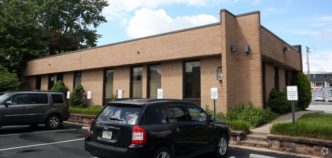

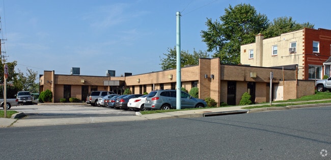
Property Detail
Belair Rd
Baltimore-Columbia-Towson, MD
PT LT 48 RAHLAND
11-1123017320
BALTIMORE
Medicalbuilding
Maryland
B and X Area of moderate flood hazard, usually the area between the limits of the 100-year and 500-year floods.
48
2024
0.26 AC
2025
Baltimore County East
411406
Baltimore
4,548 SF
NEARBY LISTINGS FOR SALE OR LEASE
DEMOGRAPHICS near Belair Rd
1 mile
3 mile
5 mile
2024 Total Population
10,189
58,926
135,641
2029 Population
10,319
59,110
136,149
Pop Growth 2024-2029
+ 1.28%
+ 0.31%
+ 0.37%
Average Age
45
43
41
2024 Total Households
4,182
22,481
53,160
HH Growth 2024-2029
+ 1.24%
+ 0.22%
+ 0.31%
Median Household Inc
$98,159
$110,005
$99,948
Avg Household Size
2.40
2.60
2.50
2024 Avg HH Vehicles
2.00
2.00
2.00
Median Home Value
$383,188
$375,054
$354,093
Median Year Built
1989
1986
1981
Nearby Places
Map Layers
Map Styles
 Street
 Aerial
Transit
 Traffic
 Biking
Places
Listings with unknown addresses are not visible on the map
- Restaurants
- Banks
- Shops
- Fitness
- Groceries
PUBLIC TRANSPORTATION
COMMUTER RAIL
Drive
Walk
Distance
17 min
9.0 mi
AIRPORT
Baltimore/Washington International Thurgood Marshall
Drive
Walk
Distance
Baltimore/Washington International Thurgood Marshall
41 min
26.2 mi
Freight Ports
Port of Baltimore
Drive
Walk
Distance
Port of Baltimore
31 min
19.7 mi
SALE & LEASE HISTORY
LISTING DATE
SALE/LEASE

Jun 29, 2020
For Lease
Jan 05, 2017
For Lease
Nearby Properties
Address
Land Use
TOTAL SIZE
Lot Size
Zoning
Address
Land Use
TOTAL SIZE
Lot Size
Zoning
527,364 SF
18.11 AC
BM
Address
Land Use
TOTAL SIZE
Lot Size
Zoning
584,740 SF
32.61 AC
Address
Land Use
TOTAL SIZE
Lot Size
Zoning
16.08 AC
DR16
Address
Land Use
TOTAL SIZE
Lot Size
Zoning
214,738 SF
5.92 AC
Address
Land Use
TOTAL SIZE
Lot Size
Zoning
190,826 SF
9.89 AC
Address
Land Use
TOTAL SIZE
Lot Size
Zoning
240,121 SF
9.97 AC
Address
Land Use
TOTAL SIZE
Lot Size
Zoning
12.20 AC
DR16
Address
Land Use
TOTAL SIZE
Lot Size
Zoning
225,070 SF
20.65 AC
Address
Land Use
TOTAL SIZE
Lot Size
Zoning
239,798 SF
11.90 AC
Address
Land Use
TOTAL SIZE
Lot Size
Zoning
222,711 SF
39.21 AC
DR55
Address
Land Use
TOTAL SIZE
Lot Size
Zoning
9.54 AC
DR16
Address
Land Use
TOTAL SIZE
Lot Size
Zoning
7.72 AC
DR5.5
Address
Land Use
TOTAL SIZE
Lot Size
Zoning
64,480 SF
20.43 AC
Address
Land Use
TOTAL SIZE
Lot Size
Zoning
12.81 AC
DR16
Address
Land Use
TOTAL SIZE
Lot Size
Zoning
12.09 AC
DR5.5
Address
Land Use
TOTAL SIZE
Lot Size
Zoning
7.85 AC
DR5.5
Address
Land Use
TOTAL SIZE
Lot Size
Zoning
9.79 AC
DR5.5
Address
Land Use
TOTAL SIZE
Lot Size
Zoning
13,708 SF
15.67 AC
BLCCC
Address
Land Use
TOTAL SIZE
Lot Size
Zoning
10,605 SF
12.96 AC
BL
Address
Land Use
TOTAL SIZE
Lot Size
Zoning
100,725 SF
6.30 AC
BL
Address
Land Use
TOTAL SIZE
Lot Size
Zoning
10.88 AC
DR16
Address
Land Use
TOTAL SIZE
Lot Size
Zoning
82,227 SF
7.20 AC
BM
Address
Land Use
TOTAL SIZE
Lot Size
Zoning
7.16 AC
BM
Address
Land Use
TOTAL SIZE
Lot Size
Zoning
16.96 AC
DR5.5
Address
Land Use
TOTAL SIZE
Lot Size
Zoning
24.17 AC
DR5.5
Address
Land Use
TOTAL SIZE
Lot Size
Zoning
115,185 SF
12.88 AC
BM
Address
Land Use
TOTAL SIZE
Lot Size
Zoning
141,550 SF
23.81 AC
ML
Address
Land Use
TOTAL SIZE
Lot Size
Zoning
100,418 SF
3.80 AC
ML
Address
Land Use
TOTAL SIZE
Lot Size
Zoning
165,000 SF
13.10 AC
Address
Land Use
TOTAL SIZE
Lot Size
Zoning
69,744 SF
9.19 AC
BL-CS
The World's #1 Commercial Real Estate Marketplace
Connect with us
© 2026 CoStar Group
The information above has been obtained from sources believed reliable. While we do not doubt its accuracy we have not verified it and make no guarantee, warranty or representation about it. It is your responsibility to independently confirm its accuracy and completeness. Any projections, opinions, assumptions, or estimates used are for example only and do not represent the current or future performance of the property. The value of this transaction to you depends on tax and other factors which should be evaluated by your tax, financial, and legal advisors. You and your advisors should conduct a careful, independent investigation of the property to determine to your satisfaction the suitability of the property for your needs.