Property Record
Belair Rd, Baltimore, MD 21236
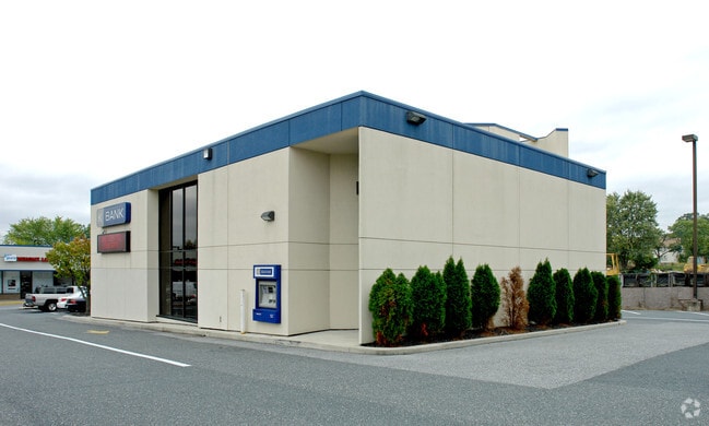

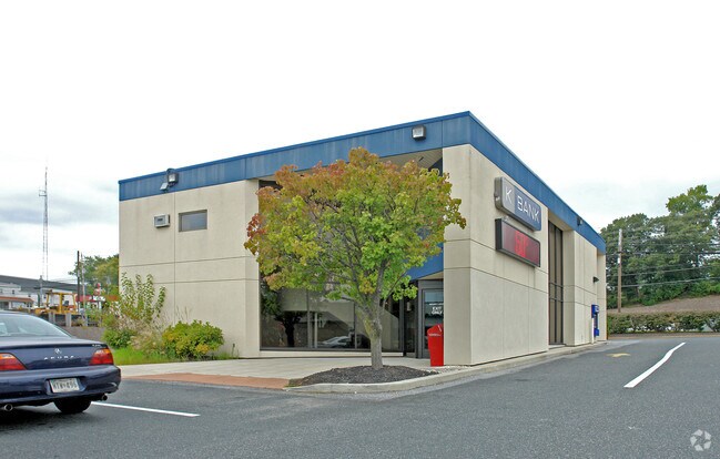
Property Detail
Belair Rd
11-1700007481
2.4400 AC PARCEL 4
Financialbuilding
BALTIMORE
BL
Maryland
B and X Area of moderate flood hazard, usually the area between the limits of the 100-year and 500-year floods.
4
2024
2.44 AC
2025
Baltimore County East
411306
Baltimore
17,285 SF
Baltimore-Columbia-Towson, MD
NEARBY LISTINGS FOR SALE OR LEASE
DEMOGRAPHICS near Belair Rd
1 mile
3 mile
5 mile
2025 Total Population
18,967
102,668
235,677
2030 Population
18,910
102,791
234,527
Pop Growth 2025-2030
(0.30%)
+ 0.12%
(0.49%)
Average Age
43
42
41
2025 Total Households
7,755
41,069
92,560
HH Growth 2025-2030
(0.41%)
+ 0.06%
(0.56%)
Median Household Inc
$90,152
$95,191
$87,089
Avg Household Size
2.40
2.40
2.50
2025 Avg HH Vehicles
2.00
2.00
2.00
Median Home Value
$327,449
$329,371
$298,834
Median Year Built
1985
1980
1970
Nearby Places
Map Layers
Map Styles
 Street
 Aerial
Transit
 Traffic
 Biking
Places
Listings with unknown addresses are not visible on the map
- Restaurants
- Banks
- Shops
- Fitness
- Groceries
PUBLIC TRANSPORTATION
COMMUTER RAIL
Martin Airport Marc Nb (PENN - WASHINGTON - Maryland Transit Administration)
Drive
Walk
Distance
Martin Airport Marc Nb (PENN - WASHINGTON - Maryland Transit Administration)
14 min
7.4 mi
Penn Station (PENN - WASHINGTON - Maryland Area Regional Commuter Trains (The MARC), Penn Line - Maryland Area Regional Commuter Trains (The MARC), Penn Station & Camden Yards - Maryland Area Regional Commuter Trains (The MARC))
Drive
Walk
Distance
Penn Station (PENN - WASHINGTON - Maryland Area Regional Commuter Trains (The MARC), Penn Line - Maryland Area Regional Commuter Trains (The MARC), Penn Station & Camden Yards - Maryland Area Regional Commuter Trains (The MARC))
24 min
9.5 mi
AIRPORT
Baltimore/Washington International Thurgood Marshall
Drive
Walk
Distance
Baltimore/Washington International Thurgood Marshall
37 min
22.9 mi
Freight Ports
Port of Baltimore
Drive
Walk
Distance
Port of Baltimore
24 min
14.2 mi
Nearby Properties
Address
Land Use
TOTAL SIZE
Lot Size
Zoning
Address
Land Use
TOTAL SIZE
Lot Size
Zoning
1,704,075 SF
76.16 AC
Address
Land Use
TOTAL SIZE
Lot Size
Zoning
307,785 SF
30.50 AC
ML
Address
Land Use
TOTAL SIZE
Lot Size
Zoning
31.22 AC
DR16
Address
Land Use
TOTAL SIZE
Lot Size
Zoning
119,200 SF
57.12 AC
Address
Land Use
TOTAL SIZE
Lot Size
Zoning
527,364 SF
18.11 AC
BM
Address
Land Use
TOTAL SIZE
Lot Size
Zoning
46.20 AC
DR105
Address
Land Use
TOTAL SIZE
Lot Size
Zoning
474,640 SF
12.42 AC
Address
Land Use
TOTAL SIZE
Lot Size
Zoning
560,700 SF
25.77 AC
Address
Land Use
TOTAL SIZE
Lot Size
Zoning
85,474 SF
22.22 AC
Address
Land Use
TOTAL SIZE
Lot Size
Zoning
584,740 SF
32.61 AC
Address
Land Use
TOTAL SIZE
Lot Size
Zoning
16.08 AC
DR16
Address
Land Use
TOTAL SIZE
Lot Size
Zoning
15.29 AC
Address
Land Use
TOTAL SIZE
Lot Size
Zoning
19.93 AC
Address
Land Use
TOTAL SIZE
Lot Size
Zoning
101,906 SF
13.54 AC
Address
Land Use
TOTAL SIZE
Lot Size
Zoning
41,184 SF
93.14 AC
EC-1
Address
Land Use
TOTAL SIZE
Lot Size
Zoning
214,738 SF
5.92 AC
Address
Land Use
TOTAL SIZE
Lot Size
Zoning
190,826 SF
9.89 AC
Address
Land Use
TOTAL SIZE
Lot Size
Zoning
240,121 SF
9.97 AC
Address
Land Use
TOTAL SIZE
Lot Size
Zoning
105,384 SF
11.52 AC
Address
Land Use
TOTAL SIZE
Lot Size
Zoning
12.20 AC
DR16
Address
Land Use
TOTAL SIZE
Lot Size
Zoning
225,070 SF
20.65 AC
Address
Land Use
TOTAL SIZE
Lot Size
Zoning
239,798 SF
11.90 AC
Address
Land Use
TOTAL SIZE
Lot Size
Zoning
9.27 AC
DR105
Address
Land Use
TOTAL SIZE
Lot Size
Zoning
222,711 SF
39.21 AC
DR55
Address
Land Use
TOTAL SIZE
Lot Size
Zoning
9.54 AC
DR16
Address
Land Use
TOTAL SIZE
Lot Size
Zoning
7.72 AC
DR5.5
Address
Land Use
TOTAL SIZE
Lot Size
Zoning
64,480 SF
20.43 AC
Address
Land Use
TOTAL SIZE
Lot Size
Zoning
427,720 SF
27.55 AC
ML
Address
Land Use
TOTAL SIZE
Lot Size
Zoning
10.51 AC
DR16
Address
Land Use
TOTAL SIZE
Lot Size
Zoning
12.81 AC
DR16
The World's #1 Commercial Real Estate Marketplace
Connect with us
© 2026 CoStar Group
The information above has been obtained from sources believed reliable. While we do not doubt its accuracy we have not verified it and make no guarantee, warranty or representation about it. It is your responsibility to independently confirm its accuracy and completeness. Any projections, opinions, assumptions, or estimates used are for example only and do not represent the current or future performance of the property. The value of this transaction to you depends on tax and other factors which should be evaluated by your tax, financial, and legal advisors. You and your advisors should conduct a careful, independent investigation of the property to determine to your satisfaction the suitability of the property for your needs.