Property Record
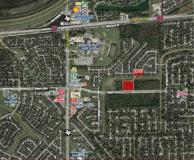
Bellaire Blvd, Houston, TX 77083
Property Detail
Bellaire Blvd
Houston-Pasadena-The Woodlands, TX
0422 T T R R, TRACT 4 (PT), ACRES 1.992
0422-00-000-0320-907
FORT BEND
Commercialacreage
Texas
B and X Area of moderate flood hazard, usually the area between the limits of the 100-year and 500-year floods.
4
2024
1.99 AC
2025
E Fort Bend Co/Sugar Land
454000
Houston
NEARBY LISTINGS FOR SALE OR LEASE
DEMOGRAPHICS near Bellaire Blvd
1 mile
3 mile
5 mile
2025 Total Population
18,810
120,339
340,423
2030 Population
20,767
132,833
374,288
Pop Growth 2025-2030
+ 10.40%
+ 10.38%
+ 9.95%
Average Age
38
37
37
2025 Total Households
5,528
37,023
109,456
HH Growth 2025-2030
+ 10.80%
+ 10.53%
+ 10.03%
Median Household Inc
$76,916
$75,051
$81,114
Avg Household Size
3.30
3.20
3.00
2025 Avg HH Vehicles
2.00
2.00
2.00
Median Home Value
$256,471
$287,695
$322,603
Median Year Built
1989
2000
2001
Nearby Places
Map Layers
Map Styles
 Street
 Aerial
Transit
 Traffic
 Biking
Places
Listings with unknown addresses are not visible on the map
- Restaurants
- Banks
- Shops
- Fitness
- Groceries
PUBLIC TRANSPORTATION
AIRPORT
William P Hobby
Drive
Walk
Distance
William P Hobby
47 min
31.9 mi
George Bush Intcntl/Houston
Drive
Walk
Distance
George Bush Intcntl/Houston
49 min
40.4 mi
Freight Ports
Port of Houston
Drive
Walk
Distance
Port of Houston
44 min
31.2 mi
SALE & LEASE HISTORY
LISTING DATE
SALE/LEASE

Apr 26, 2021
For Sale
Nearby Properties
Address
Land Use
TOTAL SIZE
Lot Size
Zoning
Address
Land Use
TOTAL SIZE
Lot Size
Zoning
1,376,776 SF
113.43 AC
Address
Land Use
TOTAL SIZE
Lot Size
Zoning
900 SF
20.64 AC
MS
Address
Land Use
TOTAL SIZE
Lot Size
Zoning
403,080 SF
19.17 AC
Address
Land Use
TOTAL SIZE
Lot Size
Zoning
14.01 AC
Address
Land Use
TOTAL SIZE
Lot Size
Zoning
8.32 AC
Address
Land Use
TOTAL SIZE
Lot Size
Zoning
12.38 AC
Address
Land Use
TOTAL SIZE
Lot Size
Zoning
363,177 SF
36.37 AC
YOS
Address
Land Use
TOTAL SIZE
Lot Size
Zoning
11.02 AC
Address
Land Use
TOTAL SIZE
Lot Size
Zoning
690,119 SF
23 AC
Address
Land Use
TOTAL SIZE
Lot Size
Zoning
364,571 SF
19.23 AC
Address
Land Use
TOTAL SIZE
Lot Size
Zoning
9.97 AC
MS
Address
Land Use
TOTAL SIZE
Lot Size
Zoning
443,209 SF
25.13 AC
Address
Land Use
TOTAL SIZE
Lot Size
Zoning
332,872 SF
13 AC
Address
Land Use
TOTAL SIZE
Lot Size
Zoning
300,014 SF
14.13 AC
Address
Land Use
TOTAL SIZE
Lot Size
Zoning
459,199 SF
15.74 AC
Address
Land Use
TOTAL SIZE
Lot Size
Zoning
351,177 SF
15.81 AC
Address
Land Use
TOTAL SIZE
Lot Size
Zoning
10.48 AC
Address
Land Use
TOTAL SIZE
Lot Size
Zoning
205,950 SF
8.50 AC
Address
Land Use
TOTAL SIZE
Lot Size
Zoning
158,975 SF
46.38 AC
YQ
Address
Land Use
TOTAL SIZE
Lot Size
Zoning
206,121 SF
23.28 AC
Address
Land Use
TOTAL SIZE
Lot Size
Zoning
311,010 SF
12.36 AC
Address
Land Use
TOTAL SIZE
Lot Size
Zoning
330,612 SF
13.41 AC
Address
Land Use
TOTAL SIZE
Lot Size
Zoning
181,840 SF
4.53 AC
Address
Land Use
TOTAL SIZE
Lot Size
Zoning
153,222 SF
15 AC
M
Address
Land Use
TOTAL SIZE
Lot Size
Zoning
89,021 SF
12 AC
Address
Land Use
TOTAL SIZE
Lot Size
Zoning
173,134 SF
7.60 AC
Address
Land Use
TOTAL SIZE
Lot Size
Zoning
169,058 SF
5.43 AC
Address
Land Use
TOTAL SIZE
Lot Size
Zoning
185,225 SF
22.43 AC
Address
Land Use
TOTAL SIZE
Lot Size
Zoning
Address
Land Use
TOTAL SIZE
Lot Size
Zoning
9.88 AC
YS
The World's #1 Commercial Real Estate Marketplace
Connect with us
© 2026 CoStar Group
The information above has been obtained from sources believed reliable. While we do not doubt its accuracy we have not verified it and make no guarantee, warranty or representation about it. It is your responsibility to independently confirm its accuracy and completeness. Any projections, opinions, assumptions, or estimates used are for example only and do not represent the current or future performance of the property. The value of this transaction to you depends on tax and other factors which should be evaluated by your tax, financial, and legal advisors. You and your advisors should conduct a careful, independent investigation of the property to determine to your satisfaction the suitability of the property for your needs.