Property Record
14959 Jacintoport Blvd, Houston, TX 77015
NEARBY LISTINGS FOR SALE OR LEASE
Property Detail
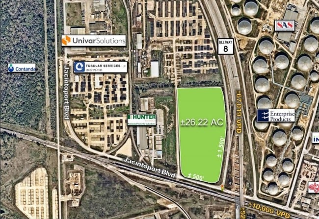
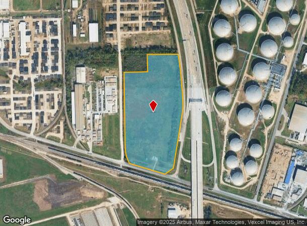
14959 Jacintoport Blvd
0410320010111
Abst 76 R & R Vince
Outdoorrecreationbeachmountaindesert
TR 1KK ABST 76 R & R VINCE
X
Harris
48201C0720M
Texas
2024
24.53 AC
2025
Gulf Freeway/Pasadena
252500
Houston
342,208 SF
Houston-The Woodlands-Sugar Land, TX
DEMOGRAPHICS near 14959 Jacintoport Blvd
1 Mile
3 Mile
5 Mile
2024 Total Population
129
48,470
165,450
2029 Population
132
49,028
167,911
Pop Growth 2024-2029
+ 2.33%
+ 1.15%
+ 1.49%
Average Age
33
33
34
2024 Total Households
39
14,081
51,577
HH Growth 2024-2029
0.00%
+ 1.07%
+ 1.43%
Median Household Inc
$47,083
$54,178
$56,722
Avg Household Size
3.30
3.30
3.10
2024 Avg HH Vehicles
2.00
2.00
2.00
Median Home Value
$126,923
$136,953
$150,933
Median Year Built
1967
1980
1979
Nearby Places
Map Layers
Map Styles
 Street
 Aerial
- Restaurants
- Banks
- Shops
- Fitness
- Groceries
PUBLIC TRANSPORTATION
AIRPORT
William P Hobby
DRIVE
WALK
Distance
William P Hobby
34 min
19.9 mi
George Bush Intcntl/Houston
DRIVE
WALK
Distance
George Bush Intcntl/Houston
29 min
24.1 mi
Freight Ports
Port of Houston
DRIVE
WALK
Distance
Port of Houston
20 min
11.9 mi
SALE & LEASE HISTORY
LISTING DATE
SALE/LEASE

Nov 12, 2019
For Sale
Jul 03, 2019
For Lease
Dec 06, 2018
For Sale
Nearby Properties
Address
Land Use
TOTAL SIZE
Lot Size
Zoning
Address
Land Use
TOTAL SIZE
Lot Size
Zoning
Address
Land Use
TOTAL SIZE
Lot Size
Zoning
16,879,748 SF
228.46 AC
Address
Land Use
TOTAL SIZE
Lot Size
Zoning
188.11 AC
Address
Land Use
TOTAL SIZE
Lot Size
Zoning
5,379,424 SF
145.51 AC
Address
Land Use
TOTAL SIZE
Lot Size
Zoning
10,093,711 SF
30.83 AC
Address
Land Use
TOTAL SIZE
Lot Size
Zoning
8,203,364 SF
183.34 AC
Address
Land Use
TOTAL SIZE
Lot Size
Zoning
9,585,990 SF
122.92 AC
Address
Land Use
TOTAL SIZE
Lot Size
Zoning
2,822,672 SF
33.97 AC
Address
Land Use
TOTAL SIZE
Lot Size
Zoning
167.71 AC
Address
Land Use
TOTAL SIZE
Lot Size
Zoning
19.38 AC
Address
Land Use
TOTAL SIZE
Lot Size
Zoning
102.48 AC
Address
Land Use
TOTAL SIZE
Lot Size
Zoning
153.75 AC
Address
Land Use
TOTAL SIZE
Lot Size
Zoning
486.59 AC
Address
Land Use
TOTAL SIZE
Lot Size
Zoning
2,936,644 SF
59.90 AC
Address
Land Use
TOTAL SIZE
Lot Size
Zoning
1,042,908 SF
28.92 AC
Address
Land Use
TOTAL SIZE
Lot Size
Zoning
680,077 SF
86.92 AC
Address
Land Use
TOTAL SIZE
Lot Size
Zoning
158.48 AC
Address
Land Use
TOTAL SIZE
Lot Size
Zoning
33.93 AC
Address
Land Use
TOTAL SIZE
Lot Size
Zoning
606,550 SF
31.17 AC
Address
Land Use
TOTAL SIZE
Lot Size
Zoning
22.02 AC
Address
Land Use
TOTAL SIZE
Lot Size
Zoning
760,851 SF
41.87 AC
Address
Land Use
TOTAL SIZE
Lot Size
Zoning
188.11 AC
Address
Land Use
TOTAL SIZE
Lot Size
Zoning
248.91 AC
Address
Land Use
TOTAL SIZE
Lot Size
Zoning
56.69 AC
Address
Land Use
TOTAL SIZE
Lot Size
Zoning
7.19 AC
Address
Land Use
TOTAL SIZE
Lot Size
Zoning
59.10 AC
Address
Land Use
TOTAL SIZE
Lot Size
Zoning
2,124,914 SF
243.08 AC
Address
Land Use
TOTAL SIZE
Lot Size
Zoning
30.84 AC
Address
Land Use
TOTAL SIZE
Lot Size
Zoning
1,306,874 SF
6.76 AC
Address
Land Use
TOTAL SIZE
Lot Size
Zoning
730,000 SF
11.57 AC
The World's #1 Commercial Real Estate Marketplace
Connect with us
© 2025 CoStar Group
The information above has been obtained from sources believed reliable. While we do not doubt its accuracy we have not verified it and make no guarantee, warranty or representation about it. It is your responsibility to independently confirm its accuracy and completeness. Any projections, opinions, assumptions, or estimates used are for example only and do not represent the current or future performance of the property. The value of this transaction to you depends on tax and other factors which should be evaluated by your tax, financial, and legal advisors. You and your advisors should conduct a careful, independent investigation of the property to determine to your satisfaction the suitability of the property for your needs.