Property Record
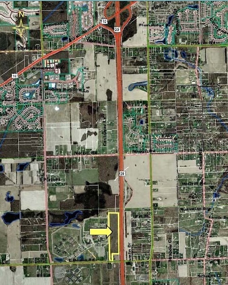
Bemis Rd, Ypsilanti, MI 48197

Property Detail
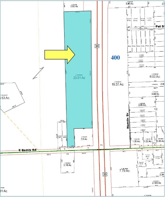
Bemis Rd
12-35-400-002
OLD SID - L 12-035-018-00 PI 35-7A-1 COM AT SE COR OF SEC, TH S 88-35-45 W 1711.50 FT IN S/L OF SEC, TH N 1-30-15 W 383.50 FT
Commercialacreage
WASHTENAW
ME
Michigan
B and X Area of moderate flood hazard, usually the area between the limits of the 100-year and 500-year floods.
23.61 AC
2025
Washtenaw W of 23
2025
Detroit
410600
Ann Arbor, MI
NEARBY LISTINGS FOR SALE OR LEASE
DEMOGRAPHICS near Bemis Rd
1 mile
3 mile
5 mile
2025 Total Population
2,400
16,584
57,923
2030 Population
2,420
16,646
58,216
Pop Growth 2025-2030
+ 0.83%
+ 0.37%
+ 0.51%
Average Age
38
40
40
2025 Total Households
250
5,531
22,181
HH Growth 2025-2030
+ 0.40%
+ 0.36%
+ 0.55%
Median Household Inc
$117,072
$117,727
$95,487
Avg Household Size
2.60
2.60
2.50
2025 Avg HH Vehicles
2.00
2.00
2.00
Median Home Value
$350,819
$356,764
$336,533
Median Year Built
1977
1992
1986
Nearby Places
Map Layers
Map Styles
 Street
 Aerial
Layers
 Traffic
 Biking
Places
Listings with unknown addresses are not visible on the map
- Restaurants
- Banks
- Shops
- Fitness
- Groceries
PUBLIC TRANSPORTATION
AIRPORT
Detroit Metro Wayne County
Drive
Walk
Distance
Detroit Metro Wayne County
32 min
26.3 mi
Freight Ports
Port of Toledo
Drive
Walk
Distance
Port of Toledo
64 min
49.8 mi
SALE & LEASE HISTORY
LISTING DATE
SALE/LEASE

Oct 07, 2019
For Sale
Nearby Properties
Address
Land Use
TOTAL SIZE
Lot Size
Zoning
Address
Land Use
TOTAL SIZE
Lot Size
Zoning
282,382 SF
305.53 AC
RPD
Address
Land Use
TOTAL SIZE
Lot Size
Zoning
112,994 SF
45.12 AC
IH
Address
Land Use
TOTAL SIZE
Lot Size
Zoning
139,500 SF
A-1
Address
Land Use
TOTAL SIZE
Lot Size
Zoning
253,702 SF
30.23 AC
Address
Land Use
TOTAL SIZE
Lot Size
Zoning
18,148 SF
21.62 AC
BI
Address
Land Use
TOTAL SIZE
Lot Size
Zoning
167,294 SF
40.67 AC
Address
Land Use
TOTAL SIZE
Lot Size
Zoning
105,615 SF
26.31 AC
Address
Land Use
TOTAL SIZE
Lot Size
Zoning
191,215 SF
30.23 AC
Address
Land Use
TOTAL SIZE
Lot Size
Zoning
17,228 SF
8.40 AC
Address
Land Use
TOTAL SIZE
Lot Size
Zoning
4,964 SF
5.86 AC
Address
Land Use
TOTAL SIZE
Lot Size
Zoning
67,220 SF
9 AC
Address
Land Use
TOTAL SIZE
Lot Size
Zoning
132,290 SF
30.91 AC
Address
Land Use
TOTAL SIZE
Lot Size
Zoning
48,996 SF
12.19 AC
R-1
Address
Land Use
TOTAL SIZE
Lot Size
Zoning
57.86 AC
Address
Land Use
TOTAL SIZE
Lot Size
Zoning
164.43 AC
RPD
Address
Land Use
TOTAL SIZE
Lot Size
Zoning
181.03 AC
RPD
Address
Land Use
TOTAL SIZE
Lot Size
Zoning
51,843 SF
13.35 AC
Address
Land Use
TOTAL SIZE
Lot Size
Zoning
49,628 SF
2.57 AC
BI
Address
Land Use
TOTAL SIZE
Lot Size
Zoning
32,361 SF
11.40 AC
II
Address
Land Use
TOTAL SIZE
Lot Size
Zoning
26,888 SF
3.19 AC
Address
Land Use
TOTAL SIZE
Lot Size
Zoning
63,712 SF
9.47 AC
II
Address
Land Use
TOTAL SIZE
Lot Size
Zoning
32,400 SF
5.16 AC
RI
Address
Land Use
TOTAL SIZE
Lot Size
Zoning
2,400 SF
23.06 AC
BI
Address
Land Use
TOTAL SIZE
Lot Size
Zoning
7,035 SF
4.58 AC
Address
Land Use
TOTAL SIZE
Lot Size
Zoning
23.72 AC
BI
Address
Land Use
TOTAL SIZE
Lot Size
Zoning
20.63 AC
BI
Address
Land Use
TOTAL SIZE
Lot Size
Zoning
45,555 SF
10.53 AC
Address
Land Use
TOTAL SIZE
Lot Size
Zoning
10,780 SF
1.45 AC
Address
Land Use
TOTAL SIZE
Lot Size
Zoning
31,690 SF
9.62 AC
BI
Address
Land Use
TOTAL SIZE
Lot Size
Zoning
24,140 SF
10.46 AC
BI
The World's #1 Commercial Real Estate Marketplace
Connect with us
© 2026 CoStar Group
The information above has been obtained from sources believed reliable. While we do not doubt its accuracy we have not verified it and make no guarantee, warranty or representation about it. It is your responsibility to independently confirm its accuracy and completeness. Any projections, opinions, assumptions, or estimates used are for example only and do not represent the current or future performance of the property. The value of this transaction to you depends on tax and other factors which should be evaluated by your tax, financial, and legal advisors. You and your advisors should conduct a careful, independent investigation of the property to determine to your satisfaction the suitability of the property for your needs.