Property Record
Bemiss Rd, Valdosta, GA 31605


Save to a Folder
{{folder.Name}}
{{folder.ListingIds.length}} Properties
{{folder.ListingIds.length}} Property
Create a New Folder
Property Detail
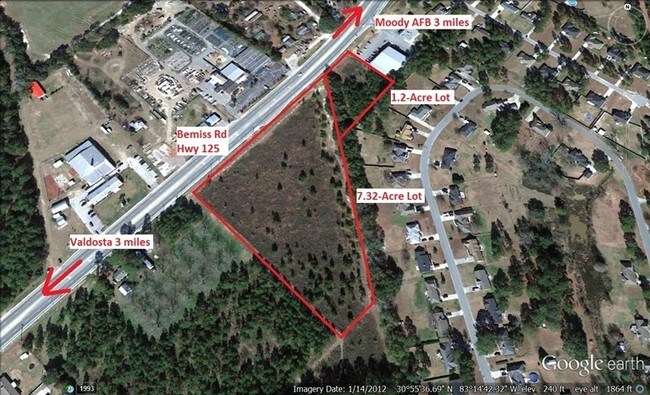
Bemiss Rd
Valdosta, GA
LOT 1 LL 131 LD 11
0145D-006A
LOWNDES
Commercialacreage
Georgia
P-D AMEND
1
B and X Area of moderate flood hazard, usually the area between the limits of the 100-year and 500-year floods.
5.67 AC
2025
Valdosta/Lake Park
2025
Other Market Areas
010102
NEARBY LISTINGS FOR SALE OR LEASE
DEMOGRAPHICS near Bemiss Rd
1 mile
3 mile
5 mile
2025 Total Population
6,446
16,235
44,014
2030 Population
6,589
16,654
45,667
Pop Growth 2025-2030
+ 2.22%
+ 2.58%
+ 3.76%
Average Age
35
35
34
2025 Total Households
2,254
5,841
16,483
HH Growth 2025-2030
+ 2.57%
+ 2.96%
+ 3.83%
Median Household Inc
$87,351
$80,104
$61,266
Avg Household Size
2.80
2.80
2.50
2025 Avg HH Vehicles
2.00
2.00
2.00
Median Home Value
$230,698
$227,882
$225,408
Median Year Built
1998
2001
1997
Nearby Places
Map Layers
Map Styles
 Street
 Aerial
Layers
 Traffic
 Biking
Places
Listings with unknown addresses are not visible on the map
- Restaurants
- Banks
- Shops
- Fitness
- Groceries
PUBLIC TRANSPORTATION
AIRPORT
Valdosta Regional
Drive
Walk
Distance
Valdosta Regional
21 min
11.0 mi
SALE & LEASE HISTORY
LISTING DATE
SALE/LEASE

Sep 24, 2016
For Sale
Nearby Properties
Address
Land Use
TOTAL SIZE
Lot Size
Zoning
Address
Land Use
TOTAL SIZE
Lot Size
Zoning
39,024 SF
18.04 AC
P-D
Address
Land Use
TOTAL SIZE
Lot Size
Zoning
1,824 SF
3.60 AC
P-D
Address
Land Use
TOTAL SIZE
Lot Size
Zoning
25,727 SF
9.12 AC
R-A
Address
Land Use
TOTAL SIZE
Lot Size
Zoning
2,096 SF
6.98 AC
P-D
Address
Land Use
TOTAL SIZE
Lot Size
Zoning
47,233 SF
5.84 AC
C-G
Address
Land Use
TOTAL SIZE
Lot Size
Zoning
40,932 SF
9.77 AC
C-H,PCD
Address
Land Use
TOTAL SIZE
Lot Size
Zoning
15,343 SF
7 AC
C-C
Address
Land Use
TOTAL SIZE
Lot Size
Zoning
48,752 SF
5.57 AC
C-C
Address
Land Use
TOTAL SIZE
Lot Size
Zoning
9,822 SF
2.63 AC
P-D
Address
Land Use
TOTAL SIZE
Lot Size
Zoning
28,688 SF
3.03 AC
P-D
Address
Land Use
TOTAL SIZE
Lot Size
Zoning
66.89 AC
C-H
Address
Land Use
TOTAL SIZE
Lot Size
Zoning
1,848 SF
6.20 AC
MAZ - 2
Address
Land Use
TOTAL SIZE
Lot Size
Zoning
41,952 SF
1.38 AC
P-D
Address
Land Use
TOTAL SIZE
Lot Size
Zoning
41,952 SF
1.38 AC
P-D
Address
Land Use
TOTAL SIZE
Lot Size
Zoning
8,400 SF
3.53 AC
C-H
Address
Land Use
TOTAL SIZE
Lot Size
Zoning
36,006 SF
17.62 AC
R-21
Address
Land Use
TOTAL SIZE
Lot Size
Zoning
29,700 SF
15 AC
R-6
Address
Land Use
TOTAL SIZE
Lot Size
Zoning
23,800 SF
4.06 AC
C-H
Address
Land Use
TOTAL SIZE
Lot Size
Zoning
268.92 AC
MAZ - 1
Address
Land Use
TOTAL SIZE
Lot Size
Zoning
4,600 SF
4.82 AC
C-G
Address
Land Use
TOTAL SIZE
Lot Size
Zoning
8,299 SF
1.02 AC
E-R
Address
Land Use
TOTAL SIZE
Lot Size
Zoning
20,500 SF
2.78 AC
C-H
Address
Land Use
TOTAL SIZE
Lot Size
Zoning
13,240 SF
1.50 AC
C-C
Address
Land Use
TOTAL SIZE
Lot Size
Zoning
2,205 SF
251.93 AC
R-1
Address
Land Use
TOTAL SIZE
Lot Size
Zoning
11,146 SF
7 AC
R-A
Address
Land Use
TOTAL SIZE
Lot Size
Zoning
6,726 SF
1.54 AC
C-H
Address
Land Use
TOTAL SIZE
Lot Size
Zoning
16,872 SF
2 AC
C-H
Address
Land Use
TOTAL SIZE
Lot Size
Zoning
2,782 SF
10 AC
C-C
Address
Land Use
TOTAL SIZE
Lot Size
Zoning
19,488 SF
6 AC
R-A
Address
Land Use
TOTAL SIZE
Lot Size
Zoning
12,000 SF
1.47 AC
C-H
The World's #1 Commercial Real Estate Marketplace
Connect with us
© 2026 CoStar Group
The information above has been obtained from sources believed reliable. While we do not doubt its accuracy we have not verified it and make no guarantee, warranty or representation about it. It is your responsibility to independently confirm its accuracy and completeness. Any projections, opinions, assumptions, or estimates used are for example only and do not represent the current or future performance of the property. The value of this transaction to you depends on tax and other factors which should be evaluated by your tax, financial, and legal advisors. You and your advisors should conduct a careful, independent investigation of the property to determine to your satisfaction the suitability of the property for your needs.