Property Record
Bennett Creek Blvd, Frederick, MD 21704

Save to a Folder
{{folder.Name}}
{{folder.ListingIds.length}} Properties
{{folder.ListingIds.length}} Property
Create a New Folder
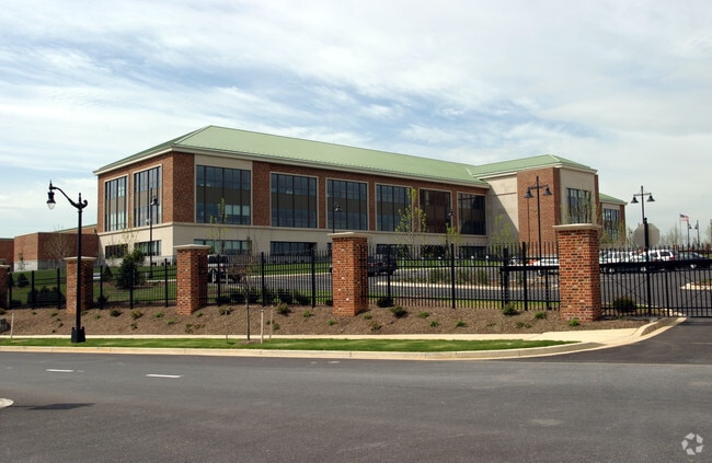
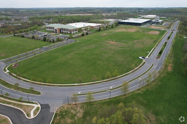
Property Detail
Bennett Creek Blvd
07-246250
LOT 701A 19.05 ACRES URBANA ORI/MXD
Officebuilding
FREDERICK
MXD
Maryland
B and X Area of moderate flood hazard, usually the area between the limits of the 100-year and 500-year floods.
701a
2024
19.05 AC
2025
I-270 Corridor North
752206
Washington, DC
367,800 SF
Washington-Arlington-Alexandria, DC-VA-MD-WV
NEARBY LISTINGS FOR SALE OR LEASE
-
-
View all Frederick listings for sale on LoopNet.com
DEMOGRAPHICS near Bennett Creek Blvd
1 mile
3 mile
5 mile
2025 Total Population
5,757
19,027
34,597
2030 Population
6,342
20,685
37,540
Pop Growth 2025-2030
+ 10.16%
+ 8.71%
+ 8.51%
Average Age
36
37
39
2025 Total Households
2,030
6,037
11,232
HH Growth 2025-2030
+ 10.94%
+ 9.13%
+ 8.73%
Median Household Inc
$168,038
$176,474
$176,189
Avg Household Size
2.70
3.10
3.00
2025 Avg HH Vehicles
2.00
2.00
2.00
Median Home Value
$561,867
$654,549
$669,663
Median Year Built
2010
2007
2004
Nearby Places
Map Layers
Map Styles
 Street
 Aerial
Layers
 Traffic
 Biking
Places
Listings with unknown addresses are not visible on the map
- Restaurants
- Banks
- Shops
- Fitness
- Groceries
PUBLIC TRANSPORTATION
COMMUTER RAIL
Drive
Walk
Distance
12 min
5.8 mi
Drive
Walk
Distance
13 min
8.2 mi
AIRPORT
Hagerstown Regional/Richard A Henson Field
Drive
Walk
Distance
Hagerstown Regional/Richard A Henson Field
50 min
37.0 mi
Ronald Reagan Washington Ntl
Drive
Walk
Distance
Ronald Reagan Washington Ntl
64 min
41.2 mi
Washington Dulles International
Drive
Walk
Distance
Washington Dulles International
69 min
47.6 mi
Freight Ports
Port of Baltimore
Drive
Walk
Distance
Port of Baltimore
66 min
48.2 mi
Nearby Properties
Address
Land Use
TOTAL SIZE
Lot Size
Zoning
Address
Land Use
TOTAL SIZE
Lot Size
Zoning
271,325 SF
20.45 AC
MXD
Address
Land Use
TOTAL SIZE
Lot Size
Zoning
442,813 SF
22.58 AC
MXD
Address
Land Use
TOTAL SIZE
Lot Size
Zoning
142,534 SF
63.30 AC
MXD
Address
Land Use
TOTAL SIZE
Lot Size
Zoning
118,055 SF
9.04 AC
MXD
Address
Land Use
TOTAL SIZE
Lot Size
Zoning
132,134 SF
19.86 AC
R1
Address
Land Use
TOTAL SIZE
Lot Size
Zoning
128,253 SF
10.68 AC
PUD
Address
Land Use
TOTAL SIZE
Lot Size
Zoning
205,000 SF
85.43 AC
A
Address
Land Use
TOTAL SIZE
Lot Size
Zoning
97,811 SF
12 AC
MXD
Address
Land Use
TOTAL SIZE
Lot Size
Zoning
86,336 SF
15.99 AC
PUD
Address
Land Use
TOTAL SIZE
Lot Size
Zoning
60,620 SF
15.99 AC
VC
Address
Land Use
TOTAL SIZE
Lot Size
Zoning
28,916 SF
7.98 AC
MXD
Address
Land Use
TOTAL SIZE
Lot Size
Zoning
28,809 SF
9.25 AC
GC
Address
Land Use
TOTAL SIZE
Lot Size
Zoning
90,480 SF
27.35 AC
LI
Address
Land Use
TOTAL SIZE
Lot Size
Zoning
14,816 SF
4.14 AC
GC
Address
Land Use
TOTAL SIZE
Lot Size
Zoning
18.21 AC
MXD
Address
Land Use
TOTAL SIZE
Lot Size
Zoning
61,760 SF
4.69 AC
LI
Address
Land Use
TOTAL SIZE
Lot Size
Zoning
30,446 SF
4.26 AC
VC
Address
Land Use
TOTAL SIZE
Lot Size
Zoning
30,981 SF
1.68 AC
PUD
Address
Land Use
TOTAL SIZE
Lot Size
Zoning
26,877 SF
129.18 AC
A
Address
Land Use
TOTAL SIZE
Lot Size
Zoning
23,624 SF
2.30 AC
VC
Address
Land Use
TOTAL SIZE
Lot Size
Zoning
35,800 SF
34.57 AC
MXD
Address
Land Use
TOTAL SIZE
Lot Size
Zoning
32,334 SF
28.20 AC
A
Address
Land Use
TOTAL SIZE
Lot Size
Zoning
27,184 SF
3.50 AC
LI
Address
Land Use
TOTAL SIZE
Lot Size
Zoning
23,193 SF
15.73 AC
VC
Address
Land Use
TOTAL SIZE
Lot Size
Zoning
8,820 SF
21.77 AC
ORI
Address
Land Use
TOTAL SIZE
Lot Size
Zoning
13,472 SF
3.75 AC
PUD
Address
Land Use
TOTAL SIZE
Lot Size
Zoning
29,157 SF
12.15 AC
A
Address
Land Use
TOTAL SIZE
Lot Size
Zoning
20,808 SF
5.75 AC
VC
Address
Land Use
TOTAL SIZE
Lot Size
Zoning
29,569 SF
5.16 AC
LI
The World's #1 Commercial Real Estate Marketplace
Connect with us
© 2026 CoStar Group
The information above has been obtained from sources believed reliable. While we do not doubt its accuracy we have not verified it and make no guarantee, warranty or representation about it. It is your responsibility to independently confirm its accuracy and completeness. Any projections, opinions, assumptions, or estimates used are for example only and do not represent the current or future performance of the property. The value of this transaction to you depends on tax and other factors which should be evaluated by your tax, financial, and legal advisors. You and your advisors should conduct a careful, independent investigation of the property to determine to your satisfaction the suitability of the property for your needs.