Property Record
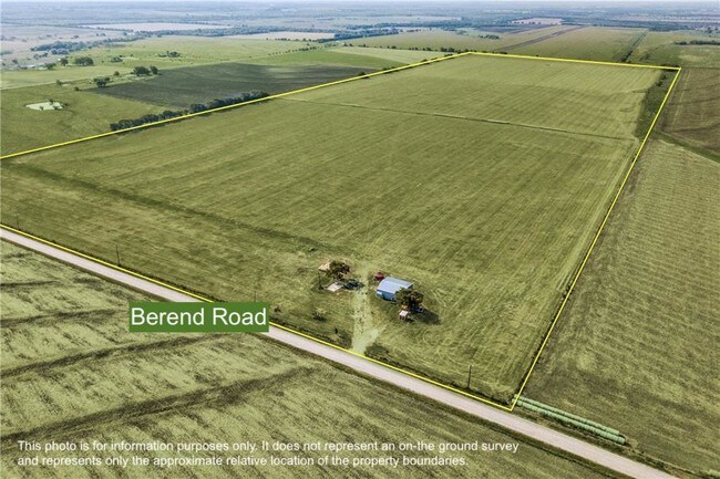
Berend Rd, Pilot Point, TX 76258

Property Detail
Berend Rd
R40793
A0195A BBB & CRR, TR 8, 125.16 ACRES, OLD DCAD TR 3
Agriculturalland
DENTON
B and X Area of moderate flood hazard, usually the area between the limits of the 100-year and 500-year floods.
Texas
2024
125.16 AC
2025
Outlying Denton County
020129
Dallas/Ft Worth
1,600 SF
Dallas-Fort Worth-Arlington, TX
NEARBY LISTINGS FOR SALE OR LEASE
-
-
View all Pilot Point listings for sale on LoopNet.com
DEMOGRAPHICS near Berend Rd
1 mile
3 mile
5 mile
2024 Total Population
151
418
6,351
2029 Population
169
482
7,494
Pop Growth 2024-2029
+ 11.92%
+ 15.31%
+ 18.00%
Average Age
39
39
40
2024 Total Households
56
150
2,282
HH Growth 2024-2029
+ 12.50%
+ 15.33%
+ 18.49%
Median Household Inc
$65,625
$82,353
$82,295
Avg Household Size
2.80
2.80
2.70
2024 Avg HH Vehicles
2.00
2.00
2.00
Median Home Value
$329,545
$360,227
$298,250
Median Year Built
1988
1996
1990
Nearby Places
Map Layers
Map Styles
 Street
 Aerial
Transit
 Traffic
 Biking
Places
Listings with unknown addresses are not visible on the map
- Restaurants
- Banks
- Shops
- Fitness
- Groceries
SALE & LEASE HISTORY
LISTING DATE
SALE/LEASE

Aug 23, 2019
For Sale
Nearby Properties
Address
Land Use
TOTAL SIZE
Lot Size
Zoning
Address
Land Use
TOTAL SIZE
Lot Size
Zoning
210,260 SF
17.39 AC
Address
Land Use
TOTAL SIZE
Lot Size
Zoning
118.80 AC
Address
Land Use
TOTAL SIZE
Lot Size
Zoning
20,725 SF
1.86 AC
Address
Land Use
TOTAL SIZE
Lot Size
Zoning
8,146 SF
4.75 AC
Address
Land Use
TOTAL SIZE
Lot Size
Zoning
6,249 SF
11.93 AC
Address
Land Use
TOTAL SIZE
Lot Size
Zoning
5,484 SF
12.61 AC
Address
Land Use
TOTAL SIZE
Lot Size
Zoning
5,810 SF
13.45 AC
Address
Land Use
TOTAL SIZE
Lot Size
Zoning
3,279 SF
6.62 AC
Address
Land Use
TOTAL SIZE
Lot Size
Zoning
11,940 SF
4.72 AC
Address
Land Use
TOTAL SIZE
Lot Size
Zoning
7,120 SF
3.98 AC
Address
Land Use
TOTAL SIZE
Lot Size
Zoning
3,765 SF
6.53 AC
Address
Land Use
TOTAL SIZE
Lot Size
Zoning
4,428 SF
5.55 AC
Address
Land Use
TOTAL SIZE
Lot Size
Zoning
3,536 SF
6.86 AC
Address
Land Use
TOTAL SIZE
Lot Size
Zoning
13.80 AC
Address
Land Use
TOTAL SIZE
Lot Size
Zoning
768 SF
15.49 AC
Address
Land Use
TOTAL SIZE
Lot Size
Zoning
4,223 SF
8.39 AC
Address
Land Use
TOTAL SIZE
Lot Size
Zoning
3,560 SF
15 AC
Address
Land Use
TOTAL SIZE
Lot Size
Zoning
2,314 SF
5.10 AC
Address
Land Use
TOTAL SIZE
Lot Size
Zoning
15.26 AC
Address
Land Use
TOTAL SIZE
Lot Size
Zoning
3,456 SF
16.94 AC
Address
Land Use
TOTAL SIZE
Lot Size
Zoning
3,329 SF
4.44 AC
Address
Land Use
TOTAL SIZE
Lot Size
Zoning
3,537 SF
16.28 AC
Address
Land Use
TOTAL SIZE
Lot Size
Zoning
2,114 SF
2 AC
Address
Land Use
TOTAL SIZE
Lot Size
Zoning
3,335 SF
9.20 AC
Address
Land Use
TOTAL SIZE
Lot Size
Zoning
Address
Land Use
TOTAL SIZE
Lot Size
Zoning
4,094 SF
11.07 AC
Address
Land Use
TOTAL SIZE
Lot Size
Zoning
2,588 SF
3.19 AC
Address
Land Use
TOTAL SIZE
Lot Size
Zoning
4,643 SF
13.11 AC
Address
Land Use
TOTAL SIZE
Lot Size
Zoning
3,199 SF
128.51 AC
The World's #1 Commercial Real Estate Marketplace
Connect with us
© 2026 CoStar Group
The information above has been obtained from sources believed reliable. While we do not doubt its accuracy we have not verified it and make no guarantee, warranty or representation about it. It is your responsibility to independently confirm its accuracy and completeness. Any projections, opinions, assumptions, or estimates used are for example only and do not represent the current or future performance of the property. The value of this transaction to you depends on tax and other factors which should be evaluated by your tax, financial, and legal advisors. You and your advisors should conduct a careful, independent investigation of the property to determine to your satisfaction the suitability of the property for your needs.