Property Record
Berry Rd, Monroe, NY 10950
Property Detail
Berry Rd
Kiryas Joel-Poughkeepsie-Newburgh, NY
ES BERRY RD
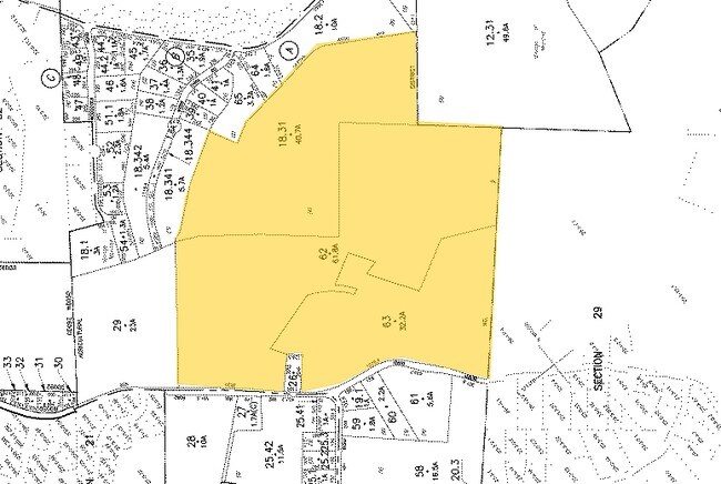
334089-031-000-0001-062.000-0000
ORANGE
Residentialacreage
New York
RR-1.0AC
63.00
AE The base floodplain where base flood elevations are provided. AE Zones are now used on new format FIRMs instead of A1-A30 Zones.
59.94 AC
2024
Monroe
2025
Northern New Jersey
014202
NEARBY LISTINGS FOR SALE OR LEASE
DEMOGRAPHICS near Berry Rd
1 mile
3 mile
5 mile
2025 Total Population
2,271
28,025
75,618
2030 Population
2,318
28,706
77,838
Pop Growth 2025-2030
+ 2.07%
+ 2.43%
+ 2.94%
Average Age
40
37
30
2025 Total Households
722
8,781
19,047
HH Growth 2025-2030
+ 2.22%
+ 2.41%
+ 3.04%
Median Household Inc
$143,088
$117,945
$91,509
Avg Household Size
3.00
3.10
3.80
2025 Avg HH Vehicles
3.00
2.00
2.00
Median Home Value
$646,551
$462,121
$519,263
Median Year Built
1975
1981
1989
Nearby Places
Map Layers
Map Styles
 Street
 Aerial
Layers
 Traffic
 Biking
Places
Listings with unknown addresses are not visible on the map
- Restaurants
- Banks
- Shops
- Fitness
- Groceries
PUBLIC TRANSPORTATION
COMMUTER RAIL
Harriman (Bergen County/Port Jervis Line - NJ Transit Commuter Rail (NJ Transit), Main/Port Jervis Line - NJ Transit Commuter Rail (NJ Transit))
Drive
Walk
Distance
Harriman (Bergen County/Port Jervis Line - NJ Transit Commuter Rail (NJ Transit), Main/Port Jervis Line - NJ Transit Commuter Rail (NJ Transit))
11 min
5.4 mi
AIRPORT
New York Stewart International
Drive
Walk
Distance
New York Stewart International
34 min
17.9 mi
Freight Ports
Port Newark Container Terminal
Drive
Walk
Distance
Port Newark Container Terminal
81 min
56.7 mi
Nearby Properties
Address
Land Use
TOTAL SIZE
Lot Size
Zoning
Address
Land Use
TOTAL SIZE
Lot Size
Zoning
103,290 SF
41.22 AC
RR-1.0AC
Address
Land Use
TOTAL SIZE
Lot Size
Zoning
125,636 SF
19.91 AC
SR-20
Address
Land Use
TOTAL SIZE
Lot Size
Zoning
124,928 SF
12.14 AC
GB
Address
Land Use
TOTAL SIZE
Lot Size
Zoning
70,760 SF
17.20 AC
GB
Address
Land Use
TOTAL SIZE
Lot Size
Zoning
91,472 SF
6.42 AC
SR-10
Address
Land Use
TOTAL SIZE
Lot Size
Zoning
911.30 AC
Address
Land Use
TOTAL SIZE
Lot Size
Zoning
159,857 SF
24.59 AC
LI
Address
Land Use
TOTAL SIZE
Lot Size
Zoning
40,040 SF
13.87 AC
SR-20
Address
Land Use
TOTAL SIZE
Lot Size
Zoning
110,219 SF
10.88 AC
LI
Address
Land Use
TOTAL SIZE
Lot Size
Zoning
172,584 SF
13.40 AC
LI
Address
Land Use
TOTAL SIZE
Lot Size
Zoning
160,774 SF
8.46 AC
LI
Address
Land Use
TOTAL SIZE
Lot Size
Zoning
89,166 SF
0.68 AC
R-M
Address
Land Use
TOTAL SIZE
Lot Size
Zoning
82,232 SF
2 AC
PD
Address
Land Use
TOTAL SIZE
Lot Size
Zoning
173,665 SF
2.40 AC
R-2
Address
Land Use
TOTAL SIZE
Lot Size
Zoning
122,913 SF
12.89 AC
LI
Address
Land Use
TOTAL SIZE
Lot Size
Zoning
111,643 SF
9.70 AC
LI
Address
Land Use
TOTAL SIZE
Lot Size
Zoning
86,366 SF
9.39 AC
GB
Address
Land Use
TOTAL SIZE
Lot Size
Zoning
2.80 AC
PD
Address
Land Use
TOTAL SIZE
Lot Size
Zoning
2.80 AC
PD
Address
Land Use
TOTAL SIZE
Lot Size
Zoning
2.80 AC
PD
Address
Land Use
TOTAL SIZE
Lot Size
Zoning
26,730 SF
4.20 AC
R-50
Address
Land Use
TOTAL SIZE
Lot Size
Zoning
49,332 SF
6.56 AC
GB
Address
Land Use
TOTAL SIZE
Lot Size
Zoning
47,553 SF
99.10 AC
AR3
Address
Land Use
TOTAL SIZE
Lot Size
Zoning
Address
Land Use
TOTAL SIZE
Lot Size
Zoning
42,100 SF
11.10 AC
IB
Address
Land Use
TOTAL SIZE
Lot Size
Zoning
2.70 AC
PD
Address
Land Use
TOTAL SIZE
Lot Size
Zoning
52,988 SF
1.93 AC
GB
Address
Land Use
TOTAL SIZE
Lot Size
Zoning
43,399 SF
15.80 AC
LI
Address
Land Use
TOTAL SIZE
Lot Size
Zoning
105,601 SF
11.36 AC
UR-M
Address
Land Use
TOTAL SIZE
Lot Size
Zoning
16,600 SF
27 AC
The World's #1 Commercial Real Estate Marketplace
Connect with us
© 2026 CoStar Group
The information above has been obtained from sources believed reliable. While we do not doubt its accuracy we have not verified it and make no guarantee, warranty or representation about it. It is your responsibility to independently confirm its accuracy and completeness. Any projections, opinions, assumptions, or estimates used are for example only and do not represent the current or future performance of the property. The value of this transaction to you depends on tax and other factors which should be evaluated by your tax, financial, and legal advisors. You and your advisors should conduct a careful, independent investigation of the property to determine to your satisfaction the suitability of the property for your needs.