Property Record
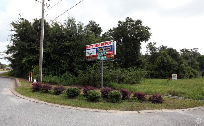
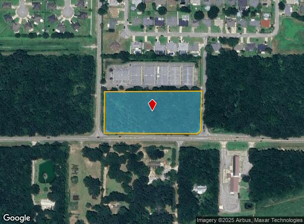
Berryhill Rd, Pace, FL 32571

Property Detail
Berryhill Rd
28-2N-29-0000-00501-0000
*DESCRIPTION UPDATE FOR 2021* PARCEL 2: COM AT SE CORNER OF SECTION 28 TOWNSHP 2 NORTH RANGE 29 WEST THN N89*3553W ALONG S SEC LINE 2059.13 FT THN N0*4439E 102.72 FT TO N R/W OF S-184-A FOR POB THN N89*1808W ALONG R/W 275.80 FT TO CURVE (R=19148.59 C
Commercialnec
SANTA ROSA
HCD
Florida
B and X Area of moderate flood hazard, usually the area between the limits of the 100-year and 500-year floods.
4.34 AC
2024
Avalon Beach/Milton
2025
Pensacola
010301
Pensacola-Ferry Pass-Brent, FL
NEARBY LISTINGS FOR SALE OR LEASE
DEMOGRAPHICS near Berryhill Rd
1 mile
3 mile
5 mile
2025 Total Population
5,165
24,423
49,155
2030 Population
5,527
26,352
53,126
Pop Growth 2025-2030
+ 7.01%
+ 7.90%
+ 8.08%
Average Age
38
40
40
2025 Total Households
1,745
8,606
17,887
HH Growth 2025-2030
+ 6.70%
+ 7.69%
+ 7.87%
Median Household Inc
$109,903
$96,604
$87,812
Avg Household Size
3.00
2.80
2.70
2025 Avg HH Vehicles
2.00
2.00
2.00
Median Home Value
$348,764
$343,538
$330,113
Median Year Built
2005
2001
1998
Nearby Places
Map Layers
Map Styles
 Street
 Aerial
Transit
 Traffic
 Biking
Places
Listings with unknown addresses are not visible on the map
- Restaurants
- Banks
- Shops
- Fitness
- Groceries
PUBLIC TRANSPORTATION
AIRPORT
Pensacola International
Drive
Walk
Distance
Pensacola International
30 min
16.7 mi
Freight Ports
Port of Mobile
Drive
Walk
Distance
Port of Mobile
80 min
65.6 mi
SALE & LEASE HISTORY
LISTING DATE
SALE/LEASE

Sep 24, 2016
For Sale
Mar 16, 2017
For Sale
Nearby Properties
Address
Land Use
TOTAL SIZE
Lot Size
Zoning
Address
Land Use
TOTAL SIZE
Lot Size
Zoning
196,877 SF
20.28 AC
HCD
Address
Land Use
TOTAL SIZE
Lot Size
Zoning
47.05 AC
AG-RR
Address
Land Use
TOTAL SIZE
Lot Size
Zoning
52,875 SF
5.24 AC
HCD
Address
Land Use
TOTAL SIZE
Lot Size
Zoning
51,329 SF
5.65 AC
HCD
Address
Land Use
TOTAL SIZE
Lot Size
Zoning
81,123 SF
8.78 AC
HCD
Address
Land Use
TOTAL SIZE
Lot Size
Zoning
23.33 AC
AG-RR
Address
Land Use
TOTAL SIZE
Lot Size
Zoning
20.76 AC
AG-RR
Address
Land Use
TOTAL SIZE
Lot Size
Zoning
43,644 SF
5.54 AC
HCD
Address
Land Use
TOTAL SIZE
Lot Size
Zoning
94,231 SF
14.72 AC
HCD
Address
Land Use
TOTAL SIZE
Lot Size
Zoning
389.54 AC
AG-RR
Address
Land Use
TOTAL SIZE
Lot Size
Zoning
80,141 SF
11.33 AC
HCD
Address
Land Use
TOTAL SIZE
Lot Size
Zoning
14,802 SF
3.68 AC
HCD
Address
Land Use
TOTAL SIZE
Lot Size
Zoning
602.07 AC
AG-RR
Address
Land Use
TOTAL SIZE
Lot Size
Zoning
25,700 SF
4.34 AC
HCD
Address
Land Use
TOTAL SIZE
Lot Size
Zoning
45,825 SF
3.26 AC
HCD
Address
Land Use
TOTAL SIZE
Lot Size
Zoning
35,878 SF
10 AC
HCD
Address
Land Use
TOTAL SIZE
Lot Size
Zoning
26,638 SF
3.08 AC
HCD
Address
Land Use
TOTAL SIZE
Lot Size
Zoning
27,839 SF
4 AC
AG-RR
Address
Land Use
TOTAL SIZE
Lot Size
Zoning
34,880 SF
2.42 AC
HCD
Address
Land Use
TOTAL SIZE
Lot Size
Zoning
14,765 SF
173.09 AC
R1
Address
Land Use
TOTAL SIZE
Lot Size
Zoning
71.77 AC
R2
Address
Land Use
TOTAL SIZE
Lot Size
Zoning
19,054 SF
25 AC
AG-RR
Address
Land Use
TOTAL SIZE
Lot Size
Zoning
2,324 SF
19.68 AC
HCD
Address
Land Use
TOTAL SIZE
Lot Size
Zoning
16,211 SF
2.05 AC
HCD
Address
Land Use
TOTAL SIZE
Lot Size
Zoning
8,574 SF
1.64 AC
HCD
Address
Land Use
TOTAL SIZE
Lot Size
Zoning
24,567 SF
2.82 AC
HCD
Address
Land Use
TOTAL SIZE
Lot Size
Zoning
11,713 SF
1.58 AC
HCD
Address
Land Use
TOTAL SIZE
Lot Size
Zoning
28,576 SF
3.49 AC
HCD
The World's #1 Commercial Real Estate Marketplace
Connect with us
© 2026 CoStar Group
The information above has been obtained from sources believed reliable. While we do not doubt its accuracy we have not verified it and make no guarantee, warranty or representation about it. It is your responsibility to independently confirm its accuracy and completeness. Any projections, opinions, assumptions, or estimates used are for example only and do not represent the current or future performance of the property. The value of this transaction to you depends on tax and other factors which should be evaluated by your tax, financial, and legal advisors. You and your advisors should conduct a careful, independent investigation of the property to determine to your satisfaction the suitability of the property for your needs.