Property Record
Bill Cheek Rd, Auburn, GA 30011


Property Detail
Bill Cheek Rd
3-003-016B
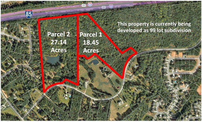
BILL CHEEK RD
Residentialacreage
GWINNETT
RA200
Georgia
A Areas with a 1% annual chance of flooding and a 26% chance of flooding over the life of a 30-year mortgage.
17.95 AC
2025
Duluth/Suwanee/Buford
2025
Atlanta
180106
Atlanta-Sandy Springs-Roswell, GA
NEARBY LISTINGS FOR SALE OR LEASE
DEMOGRAPHICS near Bill Cheek Rd
1 mile
3 mile
5 mile
2025 Total Population
5,113
34,816
93,639
2030 Population
5,426
37,334
100,957
Pop Growth 2025-2030
+ 6.12%
+ 7.23%
+ 7.82%
Average Age
36
39
40
2025 Total Households
1,468
11,109
30,153
HH Growth 2025-2030
+ 6.34%
+ 7.45%
+ 8.09%
Median Household Inc
$143,143
$123,065
$113,601
Avg Household Size
3.40
3.10
3.10
2025 Avg HH Vehicles
2.00
2.00
2.00
Median Home Value
$457,113
$490,985
$446,574
Median Year Built
2006
2005
2004
Nearby Places
Map Layers
Map Styles
 Street
 Aerial
Transit
 Traffic
 Biking
Places
Listings with unknown addresses are not visible on the map
- Restaurants
- Banks
- Shops
- Fitness
- Groceries
SALE & LEASE HISTORY
LISTING DATE
SALE/LEASE

Sep 24, 2016
For Sale
Nearby Properties
Address
Land Use
TOTAL SIZE
Lot Size
Zoning
Address
Land Use
TOTAL SIZE
Lot Size
Zoning
105,000 SF
104.18 AC
POD
Address
Land Use
TOTAL SIZE
Lot Size
Zoning
379,680 SF
76.71 AC
R100
Address
Land Use
TOTAL SIZE
Lot Size
Zoning
372,813 SF
172.70 AC
RA200
Address
Land Use
TOTAL SIZE
Lot Size
Zoning
404,091 SF
58.20 AC
RA200
Address
Land Use
TOTAL SIZE
Lot Size
Zoning
30,720 SF
12.28 AC
G-C
Address
Land Use
TOTAL SIZE
Lot Size
Zoning
381,371 SF
77.27 AC
PUD
Address
Land Use
TOTAL SIZE
Lot Size
Zoning
160,277 SF
53.35 AC
PUD
Address
Land Use
TOTAL SIZE
Lot Size
Zoning
263,400 SF
8.65 AC
PRD
Address
Land Use
TOTAL SIZE
Lot Size
Zoning
114,835 SF
15.29 AC
POD
Address
Land Use
TOTAL SIZE
Lot Size
Zoning
23,126 SF
88.56 AC
RA200
Address
Land Use
TOTAL SIZE
Lot Size
Zoning
84,890 SF
20.02 AC
RA200
Address
Land Use
TOTAL SIZE
Lot Size
Zoning
41,757 SF
19.66 AC
RA200
Address
Land Use
TOTAL SIZE
Lot Size
Zoning
42,053 SF
40.85 AC
PUD
Address
Land Use
TOTAL SIZE
Lot Size
Zoning
5,220 SF
53.11 AC
PUD
Address
Land Use
TOTAL SIZE
Lot Size
Zoning
82,604 SF
13.11 AC
G-C
Address
Land Use
TOTAL SIZE
Lot Size
Zoning
71,951 SF
8.78 AC
PRD
Address
Land Use
TOTAL SIZE
Lot Size
Zoning
1,280 SF
24.21 AC
PCD
Address
Land Use
TOTAL SIZE
Lot Size
Zoning
73,810 SF
34.67 AC
GC
Address
Land Use
TOTAL SIZE
Lot Size
Zoning
42,848 SF
4.55 AC
G-C
Address
Land Use
TOTAL SIZE
Lot Size
Zoning
24,490 SF
8.30 AC
C2
Address
Land Use
TOTAL SIZE
Lot Size
Zoning
76,566 SF
10.33 AC
PUD
Address
Land Use
TOTAL SIZE
Lot Size
Zoning
15,000 SF
7.53 AC
G-C
Address
Land Use
TOTAL SIZE
Lot Size
Zoning
35,318 SF
6.72 AC
G-C
Address
Land Use
TOTAL SIZE
Lot Size
Zoning
33,048 SF
2.50 AC
C1
Address
Land Use
TOTAL SIZE
Lot Size
Zoning
17,900 SF
21.18 AC
RA200
Address
Land Use
TOTAL SIZE
Lot Size
Zoning
8,204 SF
5.25 AC
G-C
Address
Land Use
TOTAL SIZE
Lot Size
Zoning
24,500 SF
10.71 AC
RA200
Address
Land Use
TOTAL SIZE
Lot Size
Zoning
191.82 AC
PUD
Address
Land Use
TOTAL SIZE
Lot Size
Zoning
1,412 SF
43 AC
OI
Address
Land Use
TOTAL SIZE
Lot Size
Zoning
93,158 SF
2.04 AC
PRD
The World's #1 Commercial Real Estate Marketplace
Connect with us
© 2026 CoStar Group
The information above has been obtained from sources believed reliable. While we do not doubt its accuracy we have not verified it and make no guarantee, warranty or representation about it. It is your responsibility to independently confirm its accuracy and completeness. Any projections, opinions, assumptions, or estimates used are for example only and do not represent the current or future performance of the property. The value of this transaction to you depends on tax and other factors which should be evaluated by your tax, financial, and legal advisors. You and your advisors should conduct a careful, independent investigation of the property to determine to your satisfaction the suitability of the property for your needs.