Property Record
Birmingham Dr, Encinitas, CA 92007

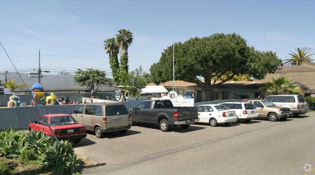

Property Detail
Birmingham Dr
San Diego-Chula Vista-Carlsbad, CA
BLK 49 LOTS 21&22 (EX ST WID) TR 001334
260-361-15
SAN DIEGO
Daycare
California
C-R11
21,22
B and X Area of moderate flood hazard, usually the area between the limits of the 100-year and 500-year floods.
0.72 AC
2024
Cardiff/Encinitas
2025
San Diego
017407
NEARBY LISTINGS FOR SALE OR LEASE
DEMOGRAPHICS near Birmingham Dr
1 mile
3 mile
5 mile
2025 Total Population
10,378
57,993
108,293
2030 Population
10,434
58,562
109,020
Pop Growth 2025-2030
+ 0.54%
+ 0.98%
+ 0.67%
Average Age
42
44
44
2025 Total Households
4,211
23,336
43,267
HH Growth 2025-2030
+ 0.45%
+ 1.04%
+ 0.76%
Median Household Inc
$171,691
$153,218
$168,728
Avg Household Size
2.40
2.40
2.40
2025 Avg HH Vehicles
2.00
2.00
2.00
Median Home Value
$1,121,112
$1,117,946
$1,119,127
Median Year Built
1974
1977
1979
Nearby Places
Map Layers
Map Styles
 Street
 Aerial
Transit
 Traffic
 Biking
Places
Listings with unknown addresses are not visible on the map
- Restaurants
- Banks
- Shops
- Fitness
- Groceries
PUBLIC TRANSPORTATION
COMMUTER RAIL
Encinitas (Coaster - San Diego North County Transit District (Coaster/Sprinter/Breeze))
Drive
Walk
Distance
Encinitas (Coaster - San Diego North County Transit District (Coaster/Sprinter/Breeze))
5 min
2.0 mi
Solana Beach (Coaster - San Diego North County Transit District (Coaster/Sprinter/Breeze))
Drive
Walk
Distance
Solana Beach (Coaster - San Diego North County Transit District (Coaster/Sprinter/Breeze))
5 min
2.6 mi
AIRPORT
San Diego International
Drive
Walk
Distance
San Diego International
30 min
22.7 mi
Freight Ports
Port of San Diego
Drive
Walk
Distance
Port of San Diego
35 min
27.0 mi
Nearby Properties
Address
Land Use
TOTAL SIZE
Lot Size
Zoning
Address
Land Use
TOTAL SIZE
Lot Size
Zoning
13.11 AC
P/SP
Address
Land Use
TOTAL SIZE
Lot Size
Zoning
17.80 AC
GC
Address
Land Use
TOTAL SIZE
Lot Size
Zoning
12.44 AC
P/SP
Address
Land Use
TOTAL SIZE
Lot Size
Zoning
4.46 AC
RR1
Address
Land Use
TOTAL SIZE
Lot Size
Zoning
4.77 AC
ER-MU1
Address
Land Use
TOTAL SIZE
Lot Size
Zoning
91,869 SF
1.72 AC
C
Address
Land Use
TOTAL SIZE
Lot Size
Zoning
8.23 AC
C
Address
Land Use
TOTAL SIZE
Lot Size
Zoning
11 AC
GC
Address
Land Use
TOTAL SIZE
Lot Size
Zoning
16.89 AC
MHRd
Address
Land Use
TOTAL SIZE
Lot Size
Zoning
4.31 AC
OP
Address
Land Use
TOTAL SIZE
Lot Size
Zoning
2.26 AC
LI
Address
Land Use
TOTAL SIZE
Lot Size
Zoning
74,583 SF
5.61 AC
R11
Address
Land Use
TOTAL SIZE
Lot Size
Zoning
7,484 SF
6.77 AC
RR2
Address
Land Use
TOTAL SIZE
Lot Size
Zoning
62,682 SF
7.36 AC
GC
Address
Land Use
TOTAL SIZE
Lot Size
Zoning
66,540 SF
6.35 AC
R11
Address
Land Use
TOTAL SIZE
Lot Size
Zoning
59,065 SF
3.06 AC
C
Address
Land Use
TOTAL SIZE
Lot Size
Zoning
62,357 SF
4.38 AC
R11
Address
Land Use
TOTAL SIZE
Lot Size
Zoning
6.96 AC
R15
Address
Land Use
TOTAL SIZE
Lot Size
Zoning
5.49 AC
R15
Address
Land Use
TOTAL SIZE
Lot Size
Zoning
71,962 SF
5.33 AC
P/SP
Address
Land Use
TOTAL SIZE
Lot Size
Zoning
9.41 AC
R15
Address
Land Use
TOTAL SIZE
Lot Size
Zoning
53,017 SF
2.08 AC
R11
Address
Land Use
TOTAL SIZE
Lot Size
Zoning
10.76 AC
GC
Address
Land Use
TOTAL SIZE
Lot Size
Zoning
97,263 SF
7.73 AC
GC
Address
Land Use
TOTAL SIZE
Lot Size
Zoning
5.80 AC
C
Address
Land Use
TOTAL SIZE
Lot Size
Zoning
71,403 SF
4.22 AC
C
Address
Land Use
TOTAL SIZE
Lot Size
Zoning
32,742 SF
5.91 AC
GC
Address
Land Use
TOTAL SIZE
Lot Size
Zoning
94,704 SF
4.21 AC
R25
Address
Land Use
TOTAL SIZE
Lot Size
Zoning
13.20 AC
ROW
Address
Land Use
TOTAL SIZE
Lot Size
Zoning
7.32 AC
GC
The World's #1 Commercial Real Estate Marketplace
Connect with us
© 2026 CoStar Group
The information above has been obtained from sources believed reliable. While we do not doubt its accuracy we have not verified it and make no guarantee, warranty or representation about it. It is your responsibility to independently confirm its accuracy and completeness. Any projections, opinions, assumptions, or estimates used are for example only and do not represent the current or future performance of the property. The value of this transaction to you depends on tax and other factors which should be evaluated by your tax, financial, and legal advisors. You and your advisors should conduct a careful, independent investigation of the property to determine to your satisfaction the suitability of the property for your needs.