Property Record
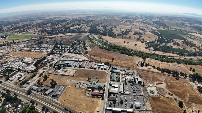
Ramada Dr, Templeton, CA 93465
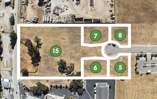
Property Detail
Ramada Dr
San Luis Obispo-Paso Robles, CA
TR 2536 LT 7
040-152-005
SAN LUIS OBISPO
Commercialacreage
California
CR
7
B and X Area of moderate flood hazard, usually the area between the limits of the 100-year and 500-year floods.
0.35 AC
2024
North 101 Corridor
2025
San Luis Obispo/Paso Robles
013100
NEARBY LISTINGS FOR SALE OR LEASE
DEMOGRAPHICS near Ramada Dr
1 mile
3 mile
5 mile
2025 Total Population
1,621
14,405
42,982
2030 Population
1,585
14,210
42,517
Pop Growth 2025-2030
(2.22%)
(1.35%)
(1.08%)
Average Age
47
41
41
2025 Total Households
677
5,290
15,879
HH Growth 2025-2030
(2.51%)
(1.63%)
(1.32%)
Median Household Inc
$92,884
$106,428
$99,150
Avg Household Size
2.40
2.60
2.60
2025 Avg HH Vehicles
2.00
2.00
2.00
Median Home Value
$508,929
$785,046
$753,623
Median Year Built
1990
1990
1987
Nearby Places
Map Layers
Map Styles
 Street
 Aerial
Layers
 Traffic
 Biking
Places
Listings with unknown addresses are not visible on the map
- Restaurants
- Banks
- Shops
- Fitness
- Groceries
PUBLIC TRANSPORTATION
COMMUTER RAIL
Paso Robles Amtrak Station (Coast Starlight - Amtrak)
Drive
Walk
Distance
Paso Robles Amtrak Station (Coast Starlight - Amtrak)
8 min
4.1 mi
AIRPORT
San Luis County Regional
Drive
Walk
Distance
San Luis County Regional
42 min
30.5 mi
Freight Ports
The Port of Hueneme
Drive
Walk
Distance
The Port of Hueneme
199 min
157.6 mi
SALE & LEASE HISTORY
LISTING DATE
SALE/LEASE

Aug 21, 2025
For Sale
Nearby Properties
Address
Land Use
TOTAL SIZE
Lot Size
Zoning
Address
Land Use
TOTAL SIZE
Lot Size
Zoning
23,092 SF
1.38 AC
Address
Land Use
TOTAL SIZE
Lot Size
Zoning
16 AC
PF
Address
Land Use
TOTAL SIZE
Lot Size
Zoning
138.68 AC
AG
Address
Land Use
TOTAL SIZE
Lot Size
Zoning
72,406 SF
4.87 AC
OP
Address
Land Use
TOTAL SIZE
Lot Size
Zoning
330,848 SF
30.24 AC
R315
Address
Land Use
TOTAL SIZE
Lot Size
Zoning
11,224 SF
4.21 AC
RC
Address
Land Use
TOTAL SIZE
Lot Size
Zoning
92,102 SF
2.79 AC
R4
Address
Land Use
TOTAL SIZE
Lot Size
Zoning
221,386 SF
10.45 AC
M
Address
Land Use
TOTAL SIZE
Lot Size
Zoning
25,298 SF
1.84 AC
RSF
Address
Land Use
TOTAL SIZE
Lot Size
Zoning
49,520 SF
1.57 AC
C2
Address
Land Use
TOTAL SIZE
Lot Size
Zoning
3.26 AC
OP
Address
Land Use
TOTAL SIZE
Lot Size
Zoning
1,448 SF
3.17 AC
C2
Address
Land Use
TOTAL SIZE
Lot Size
Zoning
12.56 AC
CR
Address
Land Use
TOTAL SIZE
Lot Size
Zoning
46,269 SF
2.30 AC
C2
Address
Land Use
TOTAL SIZE
Lot Size
Zoning
89,400 SF
7.97 AC
RC
Address
Land Use
TOTAL SIZE
Lot Size
Zoning
26,256 SF
1.19 AC
OP
Address
Land Use
TOTAL SIZE
Lot Size
Zoning
4.60 AC
CP
Address
Land Use
TOTAL SIZE
Lot Size
Zoning
44,636 SF
2.81 AC
TC2
Address
Land Use
TOTAL SIZE
Lot Size
Zoning
64,748 SF
5.41 AC
RMF
Address
Land Use
TOTAL SIZE
Lot Size
Zoning
26,866 SF
2.01 AC
OP
Address
Land Use
TOTAL SIZE
Lot Size
Zoning
46,942 SF
2.82 AC
IND
Address
Land Use
TOTAL SIZE
Lot Size
Zoning
8.75 AC
Address
Land Use
TOTAL SIZE
Lot Size
Zoning
4.45 AC
OP
Address
Land Use
TOTAL SIZE
Lot Size
Zoning
5.90 AC
R2
Address
Land Use
TOTAL SIZE
Lot Size
Zoning
228.80 AC
AG
Address
Land Use
TOTAL SIZE
Lot Size
Zoning
2,080 SF
2.76 AC
OP
Address
Land Use
TOTAL SIZE
Lot Size
Zoning
21,230 SF
2.36 AC
CR
Address
Land Use
TOTAL SIZE
Lot Size
Zoning
41,800 SF
3 AC
IND
Address
Land Use
TOTAL SIZE
Lot Size
Zoning
18,765 SF
1.30 AC
OP
Address
Land Use
TOTAL SIZE
Lot Size
Zoning
5.40 AC
RMF
The World's #1 Commercial Real Estate Marketplace
Connect with us
© 2026 CoStar Group
The information above has been obtained from sources believed reliable. While we do not doubt its accuracy we have not verified it and make no guarantee, warranty or representation about it. It is your responsibility to independently confirm its accuracy and completeness. Any projections, opinions, assumptions, or estimates used are for example only and do not represent the current or future performance of the property. The value of this transaction to you depends on tax and other factors which should be evaluated by your tax, financial, and legal advisors. You and your advisors should conduct a careful, independent investigation of the property to determine to your satisfaction the suitability of the property for your needs.