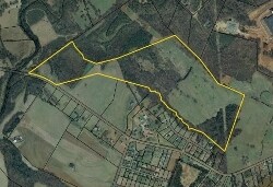
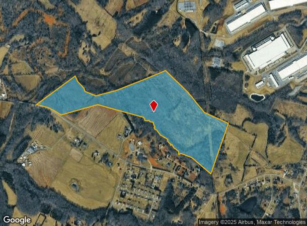
Property Record
Blackburn Bridge Rd, Lincolnton, NC 28092
NEARBY LISTINGS FOR SALE OR LEASE
Property Detail
Blackburn Bridge Rd
3627013592940000
BLACKBURN BRIDGE RD
Vacantlandnec
Catawba
AE
North Carolina
3710362700J
99.45 AC
2024
Catawba County
2025
Charlotte
070201
Hickory-Lenoir-Morganton, NC
DEMOGRAPHICS near Blackburn Bridge Rd
1 Mile
3 Mile
5 Mile
2024 Total Population
421
3,663
18,258
2029 Population
440
3,919
19,574
Pop Growth 2024-2029
+ 4.51%
+ 6.99%
+ 7.21%
Average Age
42
42
41
2024 Total Households
161
1,420
6,944
HH Growth 2024-2029
+ 4.35%
+ 6.97%
+ 7.24%
Median Household Inc
$72,154
$74,839
$69,498
Avg Household Size
2.60
2.50
2.60
2024 Avg HH Vehicles
3.00
2.00
2.00
Median Home Value
$244,079
$223,932
$191,411
Median Year Built
1991
1989
1987
Nearby Places
Map Layers
Map Styles
 Street
 Aerial
- Restaurants
- Banks
- Shops
- Fitness
- Groceries
SALE & LEASE HISTORY
LISTING DATE
SALE/LEASE

Sep 24, 2016
For Sale
Nearby Properties
Address
Land Use
TOTAL SIZE
Lot Size
Zoning
Address
Land Use
TOTAL SIZE
Lot Size
Zoning
504,574 SF
127.29 AC
321-ED(I)
Address
Land Use
TOTAL SIZE
Lot Size
Zoning
175,827 SF
54.47 AC
321-ED(I)
Address
Land Use
TOTAL SIZE
Lot Size
Zoning
62.82 AC
R-20
Address
Land Use
TOTAL SIZE
Lot Size
Zoning
216,491 SF
19.91 AC
321-ED(I)
Address
Land Use
TOTAL SIZE
Lot Size
Zoning
112 SF
710.19 AC
321-ED(I)
Address
Land Use
TOTAL SIZE
Lot Size
Zoning
70,328 SF
57.78 AC
321-ED(I)
Address
Land Use
TOTAL SIZE
Lot Size
Zoning
69,764 SF
20.01 AC
321-ED(I)
Address
Land Use
TOTAL SIZE
Lot Size
Zoning
137,440 SF
15.12 AC
M-1
Address
Land Use
TOTAL SIZE
Lot Size
Zoning
17.54 AC
R-20
Address
Land Use
TOTAL SIZE
Lot Size
Zoning
6,677 SF
2.66 AC
C-2
Address
Land Use
TOTAL SIZE
Lot Size
Zoning
116,640 SF
13.70 AC
M-1
Address
Land Use
TOTAL SIZE
Lot Size
Zoning
1,312 SF
114.81 AC
321-ED(I)
Address
Land Use
TOTAL SIZE
Lot Size
Zoning
15.16 AC
R-20
Address
Land Use
TOTAL SIZE
Lot Size
Zoning
58,107 SF
17.72 AC
321-ED(I)
Address
Land Use
TOTAL SIZE
Lot Size
Zoning
296.02 AC
M-1
Address
Land Use
TOTAL SIZE
Lot Size
Zoning
48,100 SF
4.33 AC
HC
Address
Land Use
TOTAL SIZE
Lot Size
Zoning
50.19 AC
R-40
Address
Land Use
TOTAL SIZE
Lot Size
Zoning
1,722 SF
53.55 AC
R-20
Address
Land Use
TOTAL SIZE
Lot Size
Zoning
10,640 SF
1.68 AC
321-ED(MX)
Address
Land Use
TOTAL SIZE
Lot Size
Zoning
4,824 SF
1.92 AC
R-R
Address
Land Use
TOTAL SIZE
Lot Size
Zoning
7,820 SF
20.86 AC
R-SF
Address
Land Use
TOTAL SIZE
Lot Size
Zoning
1,588 SF
306.74 AC
R-40
Address
Land Use
TOTAL SIZE
Lot Size
Zoning
3,316 SF
2.02 AC
R-40
Address
Land Use
TOTAL SIZE
Lot Size
Zoning
2,112 SF
4.30 AC
R-SF
Address
Land Use
TOTAL SIZE
Lot Size
Zoning
18,308 SF
39.96 AC
M-1
Address
Land Use
TOTAL SIZE
Lot Size
Zoning
4,045 SF
4.97 AC
321-ED(MX)
Address
Land Use
TOTAL SIZE
Lot Size
Zoning
266.22 AC
R-SF & R-R
Address
Land Use
TOTAL SIZE
Lot Size
Zoning
11.35 AC
321-ED(MX)
Address
Land Use
TOTAL SIZE
Lot Size
Zoning
4,493 SF
2.53 AC
321-ED(I)
The World's #1 Commercial Real Estate Marketplace
Connect with us
© 2026 CoStar Group
The information above has been obtained from sources believed reliable. While we do not doubt its accuracy we have not verified it and make no guarantee, warranty or representation about it. It is your responsibility to independently confirm its accuracy and completeness. Any projections, opinions, assumptions, or estimates used are for example only and do not represent the current or future performance of the property. The value of this transaction to you depends on tax and other factors which should be evaluated by your tax, financial, and legal advisors. You and your advisors should conduct a careful, independent investigation of the property to determine to your satisfaction the suitability of the property for your needs.