Property Record
Blake Dr, Dalton, GA 30720
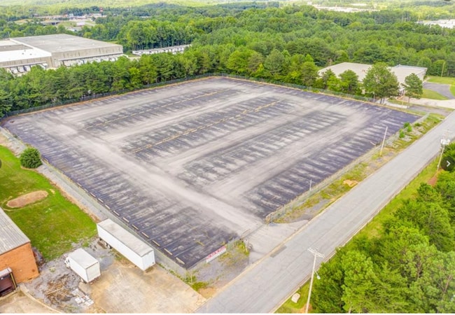

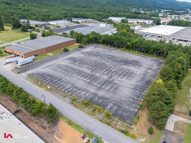
This Property Is For Sale
Current Lease Availabilities
Property Detail
Blake Dr
Dalton, GA
L4 CARPET CAPITAL PARK
13-103-09-020
WHITFIELD
Commercialacreage
Georgia
B and X Area of moderate flood hazard, usually the area between the limits of the 100-year and 500-year floods.
103
2025
3.94 AC
2025
Georgia Northwest
000900
Other Market Areas
NEARBY LISTINGS FOR SALE OR LEASE
DEMOGRAPHICS near Blake Dr
1 mile
3 mile
5 mile
2025 Total Population
498
3,899
17,262
2030 Population
516
4,019
17,758
Pop Growth 2025-2030
+ 3.61%
+ 3.08%
+ 2.87%
Average Age
40
40
39
2025 Total Households
182
1,409
5,952
HH Growth 2025-2030
+ 3.85%
+ 3.19%
+ 2.92%
Median Household Inc
$40,741
$41,824
$44,608
Avg Household Size
2.80
2.80
2.90
2025 Avg HH Vehicles
2.00
2.00
2.00
Median Home Value
$194,614
$210,000
$198,115
Median Year Built
1994
1990
1985
Nearby Places
Map Layers
Map Styles
 Street
 Aerial
Transit
 Traffic
 Biking
Places
Listings with unknown addresses are not visible on the map
- Restaurants
- Banks
- Shops
- Fitness
- Groceries
PUBLIC TRANSPORTATION
AIRPORT
Lovell Field
Drive
Walk
Distance
Lovell Field
44 min
33.3 mi
Freight Ports
Georgia Ports - Savannah
Drive
Walk
Distance
Georgia Ports - Savannah
370 min
330.4 mi
Nearby Properties
Address
Land Use
TOTAL SIZE
Lot Size
Zoning
Address
Land Use
TOTAL SIZE
Lot Size
Zoning
601,800 SF
33.86 AC
M-2
Address
Land Use
TOTAL SIZE
Lot Size
Zoning
513,638 SF
61.78 AC
M2
Address
Land Use
TOTAL SIZE
Lot Size
Zoning
266,000 SF
12.54 AC
M2
Address
Land Use
TOTAL SIZE
Lot Size
Zoning
443,997 SF
10.20 AC
M2
Address
Land Use
TOTAL SIZE
Lot Size
Zoning
308,480 SF
87.86 AC
M-2
Address
Land Use
TOTAL SIZE
Lot Size
Zoning
232,960 SF
11.63 AC
M-2
Address
Land Use
TOTAL SIZE
Lot Size
Zoning
200,000 SF
15.18 AC
M-2
Address
Land Use
TOTAL SIZE
Lot Size
Zoning
189,280 SF
8.18 AC
M-2
Address
Land Use
TOTAL SIZE
Lot Size
Zoning
69,590 SF
29.96 AC
Address
Land Use
TOTAL SIZE
Lot Size
Zoning
341,549 SF
25.46 AC
Address
Land Use
TOTAL SIZE
Lot Size
Zoning
827,500 SF
162.17 AC
M2
Address
Land Use
TOTAL SIZE
Lot Size
Zoning
183,550 SF
53.09 AC
M2
Address
Land Use
TOTAL SIZE
Lot Size
Zoning
250,000 SF
12.50 AC
M2
Address
Land Use
TOTAL SIZE
Lot Size
Zoning
255,350 SF
18.64 AC
Address
Land Use
TOTAL SIZE
Lot Size
Zoning
130,290 SF
23.82 AC
Address
Land Use
TOTAL SIZE
Lot Size
Zoning
100,170 SF
7.83 AC
M-2
Address
Land Use
TOTAL SIZE
Lot Size
Zoning
281,625 SF
19.58 AC
M2
Address
Land Use
TOTAL SIZE
Lot Size
Zoning
344,550 SF
24.39 AC
M2
Address
Land Use
TOTAL SIZE
Lot Size
Zoning
277,385 SF
10.22 AC
Address
Land Use
TOTAL SIZE
Lot Size
Zoning
227,111 SF
16.09 AC
Address
Land Use
TOTAL SIZE
Lot Size
Zoning
58,500 SF
48.69 AC
M-2
Address
Land Use
TOTAL SIZE
Lot Size
Zoning
180,109 SF
10.36 AC
Address
Land Use
TOTAL SIZE
Lot Size
Zoning
104.47 AC
C-2
Address
Land Use
TOTAL SIZE
Lot Size
Zoning
107,908 SF
45.69 AC
M2
Address
Land Use
TOTAL SIZE
Lot Size
Zoning
97,732 SF
17.05 AC
Address
Land Use
TOTAL SIZE
Lot Size
Zoning
103,125 SF
5.68 AC
M-2
Address
Land Use
TOTAL SIZE
Lot Size
Zoning
92,338 SF
18.50 AC
M2
Address
Land Use
TOTAL SIZE
Lot Size
Zoning
182,295 SF
23.53 AC
Address
Land Use
TOTAL SIZE
Lot Size
Zoning
124,682 SF
8.57 AC
C2
Address
Land Use
TOTAL SIZE
Lot Size
Zoning
141,520 SF
8 AC
M-2
The World's #1 Commercial Real Estate Marketplace
Connect with us
© 2026 CoStar Group
The information above has been obtained from sources believed reliable. While we do not doubt its accuracy we have not verified it and make no guarantee, warranty or representation about it. It is your responsibility to independently confirm its accuracy and completeness. Any projections, opinions, assumptions, or estimates used are for example only and do not represent the current or future performance of the property. The value of this transaction to you depends on tax and other factors which should be evaluated by your tax, financial, and legal advisors. You and your advisors should conduct a careful, independent investigation of the property to determine to your satisfaction the suitability of the property for your needs.