Property Record
Blivin St, Spring Grove, IL 60081
NEARBY LISTINGS FOR SALE OR LEASE
-
-
View all Spring Grove listings for sale on LoopNet.com
Property Detail
Blivin St
Chicago-Naperville-Elgin, IL-IN
Main Blivin Hatchasse Oak Grove Shea Rab
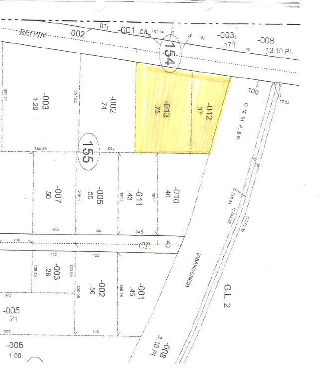
05-30-155-013
DOC 2014R0026789 PT LYING SLY OF RR & E OF BLIVIN ST PT GOV LT 2 NW1/4 MEMO: BLIVIN ST DEDICATED PER UNRECORDED ORDINANCE DATED 1937 - 80FT ROW
Vacantlandnec
McHenry
X
Illinois
17111C0103J
2
2024
0.75 AC
2024
Far Northwest
870105
Chicago
DEMOGRAPHICS near Blivin St
1 Mile
3 Mile
5 Mile
2024 Total Population
1,443
14,424
37,050
2029 Population
1,461
14,527
37,394
Pop Growth 2024-2029
+ 1.25%
+ 0.71%
+ 0.93%
Average Age
43
44
44
2024 Total Households
520
5,798
15,148
HH Growth 2024-2029
+ 1.15%
+ 0.74%
+ 0.90%
Median Household Inc
$127,833
$92,138
$83,523
Avg Household Size
2.80
2.40
2.40
2024 Avg HH Vehicles
2.00
2.00
2.00
Median Home Value
$335,246
$269,886
$266,258
Median Year Built
1996
1989
1978
Nearby Places
Map Layers
Map Styles
 Street
 Aerial
- Restaurants
- Banks
- Shops
- Fitness
- Groceries
PUBLIC TRANSPORTATION
COMMUTER RAIL
Fox Lake Station (Milwaukee District North Line - Northeast Illinois Regional Commuter Railroad (Metra))
DRIVE
WALK
Distance
Fox Lake Station (Milwaukee District North Line - Northeast Illinois Regional Commuter Railroad (Metra))
6 min
4.5 mi
Ingleside Station (Milwaukee District North Line - Northeast Illinois Regional Commuter Railroad (Metra))
DRIVE
WALK
Distance
Ingleside Station (Milwaukee District North Line - Northeast Illinois Regional Commuter Railroad (Metra))
11 min
6.5 mi
AIRPORT
Chicago O'Hare International
DRIVE
WALK
Distance
Chicago O'Hare International
80 min
47.0 mi
Freight Ports
Port Milwaukee
DRIVE
WALK
Distance
Port Milwaukee
74 min
57.4 mi
Nearby Properties
Address
Land Use
TOTAL SIZE
Lot Size
Zoning
Address
Land Use
TOTAL SIZE
Lot Size
Zoning
327,323 SF
31.01 AC
Address
Land Use
TOTAL SIZE
Lot Size
Zoning
63,970 SF
7 AC
Address
Land Use
TOTAL SIZE
Lot Size
Zoning
363,291 SF
43 AC
Address
Land Use
TOTAL SIZE
Lot Size
Zoning
1.48 AC
Address
Land Use
TOTAL SIZE
Lot Size
Zoning
7,600 SF
0.50 AC
Address
Land Use
TOTAL SIZE
Lot Size
Zoning
71,988 SF
4.74 AC
Address
Land Use
TOTAL SIZE
Lot Size
Zoning
46,576 SF
2.68 AC
Address
Land Use
TOTAL SIZE
Lot Size
Zoning
Address
Land Use
TOTAL SIZE
Lot Size
Zoning
95,760 SF
10.46 AC
Address
Land Use
TOTAL SIZE
Lot Size
Zoning
29,768 SF
2.50 AC
Address
Land Use
TOTAL SIZE
Lot Size
Zoning
47,606 SF
3.34 AC
Address
Land Use
TOTAL SIZE
Lot Size
Zoning
1,513 SF
2.27 AC
Address
Land Use
TOTAL SIZE
Lot Size
Zoning
36,096 SF
2.64 AC
Address
Land Use
TOTAL SIZE
Lot Size
Zoning
47,250 SF
2.70 AC
Address
Land Use
TOTAL SIZE
Lot Size
Zoning
13,765 SF
0.65 AC
Address
Land Use
TOTAL SIZE
Lot Size
Zoning
3,940 SF
0.37 AC
Address
Land Use
TOTAL SIZE
Lot Size
Zoning
10,786 SF
2 AC
Address
Land Use
TOTAL SIZE
Lot Size
Zoning
18,000 SF
2.07 AC
Address
Land Use
TOTAL SIZE
Lot Size
Zoning
33,500 SF
1.84 AC
Address
Land Use
TOTAL SIZE
Lot Size
Zoning
13,061 SF
0.91 AC
Address
Land Use
TOTAL SIZE
Lot Size
Zoning
4,245 SF
9.57 AC
Address
Land Use
TOTAL SIZE
Lot Size
Zoning
32,034 SF
1.84 AC
Address
Land Use
TOTAL SIZE
Lot Size
Zoning
Address
Land Use
TOTAL SIZE
Lot Size
Zoning
27,920 SF
1 AC
Address
Land Use
TOTAL SIZE
Lot Size
Zoning
16,240 SF
2.24 AC
Address
Land Use
TOTAL SIZE
Lot Size
Zoning
28,162 SF
1.84 AC
Address
Land Use
TOTAL SIZE
Lot Size
Zoning
52,000 SF
3.13 AC
Address
Land Use
TOTAL SIZE
Lot Size
Zoning
51,513 SF
4.10 AC
Address
Land Use
TOTAL SIZE
Lot Size
Zoning
35,575 SF
3.34 AC
Address
Land Use
TOTAL SIZE
Lot Size
Zoning
4,506 SF
0.95 AC
The World's #1 Commercial Real Estate Marketplace
Connect with us
© 2026 CoStar Group
The information above has been obtained from sources believed reliable. While we do not doubt its accuracy we have not verified it and make no guarantee, warranty or representation about it. It is your responsibility to independently confirm its accuracy and completeness. Any projections, opinions, assumptions, or estimates used are for example only and do not represent the current or future performance of the property. The value of this transaction to you depends on tax and other factors which should be evaluated by your tax, financial, and legal advisors. You and your advisors should conduct a careful, independent investigation of the property to determine to your satisfaction the suitability of the property for your needs.