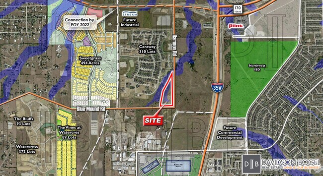
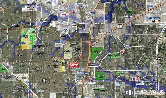
Property Record
Blue Mound Rd E, Haslet, TX 76052

Property Detail
Blue Mound Rd E
Dallas-Fort Worth-Arlington, TX
HOPKINS, ELDRIDGE SURVEY ABSTRACT 646 TRACT 1L
42243121
TARRANT
Residentialacreage
Texas
AE The base floodplain where base flood elevations are provided. AE Zones are now used on new format FIRMs instead of A1-A30 Zones.
9.09 AC
2025
Alliance
2025
Dallas/Ft Worth
114111
NEARBY LISTINGS FOR SALE OR LEASE
DEMOGRAPHICS near Blue Mound Rd E
1 mile
3 mile
5 mile
2025 Total Population
3,942
66,017
193,857
2030 Population
4,176
69,942
206,915
Pop Growth 2025-2030
+ 5.94%
+ 5.95%
+ 6.74%
Average Age
37
35
35
2025 Total Households
1,490
22,129
62,855
HH Growth 2025-2030
+ 5.50%
+ 6.29%
+ 6.93%
Median Household Inc
$119,918
$113,319
$119,737
Avg Household Size
2.60
3.00
3.00
2025 Avg HH Vehicles
2.00
2.00
2.00
Median Home Value
$438,497
$396,141
$390,347
Median Year Built
2010
2008
2008
Nearby Places
Map Layers
Map Styles
 Street
 Aerial
Layers
 Traffic
 Biking
Places
Listings with unknown addresses are not visible on the map
- Restaurants
- Banks
- Shops
- Fitness
- Groceries
PUBLIC TRANSPORTATION
AIRPORT
Dallas-Fort Worth International
Drive
Walk
Distance
Dallas-Fort Worth International
30 min
22.6 mi
Dallas Love Field
Drive
Walk
Distance
Dallas Love Field
49 min
36.3 mi
SALE & LEASE HISTORY
LISTING DATE
SALE/LEASE

Oct 03, 2022
For Sale
Nearby Properties
Address
Land Use
TOTAL SIZE
Lot Size
Zoning
Address
Land Use
TOTAL SIZE
Lot Size
Zoning
348,270 SF
39.34 AC
Address
Land Use
TOTAL SIZE
Lot Size
Zoning
252,365 SF
20.53 AC
Address
Land Use
TOTAL SIZE
Lot Size
Zoning
681,942 SF
29.37 AC
Address
Land Use
TOTAL SIZE
Lot Size
Zoning
1,251,250 SF
70.14 AC
Address
Land Use
TOTAL SIZE
Lot Size
Zoning
311,224 SF
8.22 AC
Address
Land Use
TOTAL SIZE
Lot Size
Zoning
471,408 SF
17.56 AC
Address
Land Use
TOTAL SIZE
Lot Size
Zoning
1,150,000 SF
117.10 AC
Address
Land Use
TOTAL SIZE
Lot Size
Zoning
1,141,133 SF
67.79 AC
Address
Land Use
TOTAL SIZE
Lot Size
Zoning
362,688 SF
34.18 AC
Address
Land Use
TOTAL SIZE
Lot Size
Zoning
882,565 SF
56.65 AC
Address
Land Use
TOTAL SIZE
Lot Size
Zoning
340,366 SF
53 AC
Address
Land Use
TOTAL SIZE
Lot Size
Zoning
259,825 SF
14.95 AC
Address
Land Use
TOTAL SIZE
Lot Size
Zoning
270,000 SF
42.20 AC
Address
Land Use
TOTAL SIZE
Lot Size
Zoning
314,241 SF
13.98 AC
Address
Land Use
TOTAL SIZE
Lot Size
Zoning
377,934 SF
16.02 AC
Address
Land Use
TOTAL SIZE
Lot Size
Zoning
175,000 SF
14.48 AC
Address
Land Use
TOTAL SIZE
Lot Size
Zoning
308,713 SF
17.58 AC
Address
Land Use
TOTAL SIZE
Lot Size
Zoning
807,229 SF
46.10 AC
Address
Land Use
TOTAL SIZE
Lot Size
Zoning
295,161 SF
257.32 AC
Address
Land Use
TOTAL SIZE
Lot Size
Zoning
293,939 SF
16.63 AC
Address
Land Use
TOTAL SIZE
Lot Size
Zoning
279,612 SF
18.46 AC
Address
Land Use
TOTAL SIZE
Lot Size
Zoning
332,287 SF
11.72 AC
Address
Land Use
TOTAL SIZE
Lot Size
Zoning
727,900 SF
40.15 AC
Address
Land Use
TOTAL SIZE
Lot Size
Zoning
412,258 SF
12.62 AC
Address
Land Use
TOTAL SIZE
Lot Size
Zoning
707,940 SF
35.33 AC
Address
Land Use
TOTAL SIZE
Lot Size
Zoning
268,573 SF
11.09 AC
Address
Land Use
TOTAL SIZE
Lot Size
Zoning
677,700 SF
42.17 AC
Address
Land Use
TOTAL SIZE
Lot Size
Zoning
267,831 SF
17.40 AC
Address
Land Use
TOTAL SIZE
Lot Size
Zoning
222,672 SF
8.73 AC
Address
Land Use
TOTAL SIZE
Lot Size
Zoning
634,042 SF
35.88 AC
The World's #1 Commercial Real Estate Marketplace
Connect with us
© 2026 CoStar Group
The information above has been obtained from sources believed reliable. While we do not doubt its accuracy we have not verified it and make no guarantee, warranty or representation about it. It is your responsibility to independently confirm its accuracy and completeness. Any projections, opinions, assumptions, or estimates used are for example only and do not represent the current or future performance of the property. The value of this transaction to you depends on tax and other factors which should be evaluated by your tax, financial, and legal advisors. You and your advisors should conduct a careful, independent investigation of the property to determine to your satisfaction the suitability of the property for your needs.