Property Record
Blue Ridge Rd, Black Mountain, NC 28711
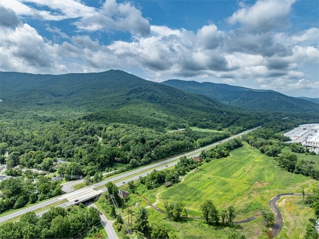
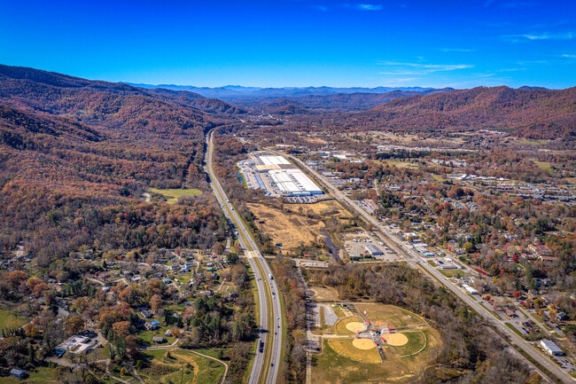
This Property Is For Sale
Property Detail
Blue Ridge Rd
Asheville, NC
LOT: LOT 3 PLAT: 0190-0043
0609-62-2560-00000
BUNCOMBE
Commercialacreage
North Carolina
LI-8
3
AE The base floodplain where base flood elevations are provided. AE Zones are now used on new format FIRMs instead of A1-A30 Zones.
20.40 AC
2024
Buncombe County
2025
Asheville
003002
NEARBY LISTINGS FOR SALE OR LEASE
DEMOGRAPHICS near Blue Ridge Rd
1 mile
3 mile
5 mile
2025 Total Population
3,509
16,735
25,596
2030 Population
3,681
17,478
26,662
Pop Growth 2025-2030
+ 4.90%
+ 4.44%
+ 4.16%
Average Age
49
46
45
2025 Total Households
1,448
7,093
10,585
HH Growth 2025-2030
+ 4.90%
+ 4.26%
+ 4.02%
Median Household Inc
$76,950
$74,472
$72,916
Avg Household Size
2.10
2.20
2.20
2025 Avg HH Vehicles
2.00
2.00
2.00
Median Home Value
$436,551
$414,064
$398,230
Median Year Built
1991
1988
1987
Nearby Places
Map Layers
Map Styles
 Street
 Aerial
Layers
 Traffic
 Biking
Places
Listings with unknown addresses are not visible on the map
- Restaurants
- Banks
- Shops
- Fitness
- Groceries
PUBLIC TRANSPORTATION
AIRPORT
Asheville Regional
Drive
Walk
Distance
Asheville Regional
30 min
20.6 mi
Freight Ports
North Charleston Terminal
Drive
Walk
Distance
North Charleston Terminal
302 min
264.3 mi
Nearby Properties
Address
Land Use
TOTAL SIZE
Lot Size
Zoning
Address
Land Use
TOTAL SIZE
Lot Size
Zoning
300,000 SF
51.82 AC
PS
Address
Land Use
TOTAL SIZE
Lot Size
Zoning
810,074 SF
46.41 AC
LI-8
Address
Land Use
TOTAL SIZE
Lot Size
Zoning
192,232 SF
119.64 AC
OI-6
Address
Land Use
TOTAL SIZE
Lot Size
Zoning
405,624 SF
75.73 AC
OI-6
Address
Land Use
TOTAL SIZE
Lot Size
Zoning
208,084 SF
156.33 AC
PS
Address
Land Use
TOTAL SIZE
Lot Size
Zoning
771,179 SF
73.04 AC
LI-8
Address
Land Use
TOTAL SIZE
Lot Size
Zoning
31,469 SF
1,153.53 AC
CR
Address
Land Use
TOTAL SIZE
Lot Size
Zoning
72,628 SF
8.65 AC
NMU-8
Address
Land Use
TOTAL SIZE
Lot Size
Zoning
14,692 SF
11 AC
PS
Address
Land Use
TOTAL SIZE
Lot Size
Zoning
32,988 SF
89.19 AC
ICD
Address
Land Use
TOTAL SIZE
Lot Size
Zoning
56,352 SF
48.90 AC
PS
Address
Land Use
TOTAL SIZE
Lot Size
Zoning
37,471 SF
7.56 AC
OI-6
Address
Land Use
TOTAL SIZE
Lot Size
Zoning
96,312 SF
10.79 AC
HB-8
Address
Land Use
TOTAL SIZE
Lot Size
Zoning
28,512 SF
4.22 AC
HB-8
Address
Land Use
TOTAL SIZE
Lot Size
Zoning
18,016 SF
2.61 AC
HB-8
Address
Land Use
TOTAL SIZE
Lot Size
Zoning
42,215 SF
112.91 AC
R-LD
Address
Land Use
TOTAL SIZE
Lot Size
Zoning
165,852 SF
14.02 AC
HI-0
Address
Land Use
TOTAL SIZE
Lot Size
Zoning
27,762 SF
4.45 AC
NMU-8
Address
Land Use
TOTAL SIZE
Lot Size
Zoning
14,172 SF
3.17 AC
HB-8
Address
Land Use
TOTAL SIZE
Lot Size
Zoning
31,196 SF
43.77 AC
PS
Address
Land Use
TOTAL SIZE
Lot Size
Zoning
22,704 SF
4.85 AC
CR
Address
Land Use
TOTAL SIZE
Lot Size
Zoning
16,092 SF
1.94 AC
TND
Address
Land Use
TOTAL SIZE
Lot Size
Zoning
40,644 SF
5.60 AC
HB-8
Address
Land Use
TOTAL SIZE
Lot Size
Zoning
12,368 SF
2.12 AC
HB-8
Address
Land Use
TOTAL SIZE
Lot Size
Zoning
41,869 SF
476.48 AC
CR
Address
Land Use
TOTAL SIZE
Lot Size
Zoning
47,890 SF
7.10 AC
HI-0
Address
Land Use
TOTAL SIZE
Lot Size
Zoning
25,245 SF
2.84 AC
NMU-8
Address
Land Use
TOTAL SIZE
Lot Size
Zoning
12,202 SF
1.29 AC
HB-8
Address
Land Use
TOTAL SIZE
Lot Size
Zoning
43,219 SF
10.74 AC
HB-8
Address
Land Use
TOTAL SIZE
Lot Size
Zoning
17,912 SF
2.08 AC
CB
The World's #1 Commercial Real Estate Marketplace
Connect with us
© 2026 CoStar Group
The information above has been obtained from sources believed reliable. While we do not doubt its accuracy we have not verified it and make no guarantee, warranty or representation about it. It is your responsibility to independently confirm its accuracy and completeness. Any projections, opinions, assumptions, or estimates used are for example only and do not represent the current or future performance of the property. The value of this transaction to you depends on tax and other factors which should be evaluated by your tax, financial, and legal advisors. You and your advisors should conduct a careful, independent investigation of the property to determine to your satisfaction the suitability of the property for your needs.