Property Record
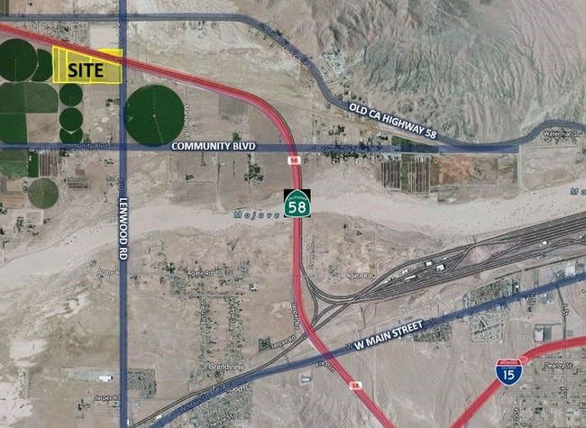
Blue Star Memorial Hwy, Hinkley, CA 92347
NEARBY LISTINGS FOR SALE OR LEASE
-
-
View all Hinkley listings for sale on LoopNet.com
Property Detail
Blue Star Memorial Hwy
0497-192-02
SE 1/4 NE 1/4 SEC 31 TP 10N R 2W EX RR AND EX E 30 FT CO RD AND EX HWY
Vacantlandnec
San Bernardino
D
California
06071C3915J
20.34 AC
2024
Mojave River Valley
2025
Inland Empire (California)
011900
Riverside-San Bernardino-Ontario, CA
DEMOGRAPHICS near Blue Star Memorial Hwy
1 Mile
3 Mile
5 Mile
2024 Total Population
173
3,513
9,415
2029 Population
186
3,644
9,809
Pop Growth 2024-2029
+ 7.51%
+ 3.73%
+ 4.18%
Average Age
42
36
37
2024 Total Households
63
1,203
3,218
HH Growth 2024-2029
+ 7.94%
+ 3.66%
+ 4.16%
Median Household Inc
$33,269
$55,794
$56,812
Avg Household Size
2.60
2.80
2.90
2024 Avg HH Vehicles
2.00
2.00
2.00
Median Home Value
$72,727
$95,860
$98,283
Median Year Built
1974
1972
1972
Nearby Places
Map Layers
Map Styles
 Street
 Aerial
- Restaurants
- Banks
- Shops
- Fitness
- Groceries
PUBLIC TRANSPORTATION
COMMUTER RAIL
Barstow (Southwest Chief - Amtrak)
DRIVE
WALK
Distance
Barstow (Southwest Chief - Amtrak)
13 min
8.3 mi
Freight Ports
Port of Long Beach
DRIVE
WALK
Distance
Port of Long Beach
150 min
129.6 mi
SALE & LEASE HISTORY
LISTING DATE
SALE/LEASE

Jul 29, 2017
For Sale
Nearby Properties
Address
Land Use
TOTAL SIZE
Lot Size
Zoning
Address
Land Use
TOTAL SIZE
Lot Size
Zoning
87,534 SF
19.40 AC
Address
Land Use
TOTAL SIZE
Lot Size
Zoning
7,808 SF
117.11 AC
RL10AP
Address
Land Use
TOTAL SIZE
Lot Size
Zoning
804 SF
55.30 AC
RL5
Address
Land Use
TOTAL SIZE
Lot Size
Zoning
9,100 SF
1.25 AC
CR
Address
Land Use
TOTAL SIZE
Lot Size
Zoning
77.51 AC
Address
Land Use
TOTAL SIZE
Lot Size
Zoning
3,162 SF
113 AC
RL5
Address
Land Use
TOTAL SIZE
Lot Size
Zoning
28,818 SF
2.47 AC
CR
Address
Land Use
TOTAL SIZE
Lot Size
Zoning
27,466 SF
2.07 AC
CR
Address
Land Use
TOTAL SIZE
Lot Size
Zoning
9,600 SF
5.53 AC
Address
Land Use
TOTAL SIZE
Lot Size
Zoning
6,046 SF
65.84 AC
RL10AP
Address
Land Use
TOTAL SIZE
Lot Size
Zoning
68.12 AC
RL
Address
Land Use
TOTAL SIZE
Lot Size
Zoning
114.36 AC
RL5
Address
Land Use
TOTAL SIZE
Lot Size
Zoning
3,379 SF
38.42 AC
RL5
Address
Land Use
TOTAL SIZE
Lot Size
Zoning
6,000 SF
4.04 AC
Address
Land Use
TOTAL SIZE
Lot Size
Zoning
2,037 SF
0.75 AC
CR
Address
Land Use
TOTAL SIZE
Lot Size
Zoning
4,820 SF
36.67 AC
IR
Address
Land Use
TOTAL SIZE
Lot Size
Zoning
40 AC
RL5
Address
Land Use
TOTAL SIZE
Lot Size
Zoning
2,400 SF
34.24 AC
IR
Address
Land Use
TOTAL SIZE
Lot Size
Zoning
20,480 SF
4.41 AC
Address
Land Use
TOTAL SIZE
Lot Size
Zoning
19.70 AC
AG
Address
Land Use
TOTAL SIZE
Lot Size
Zoning
319.60 AC
RL
Address
Land Use
TOTAL SIZE
Lot Size
Zoning
39.09 AC
RL
Address
Land Use
TOTAL SIZE
Lot Size
Zoning
37.91 AC
RL
Address
Land Use
TOTAL SIZE
Lot Size
Zoning
5.01 AC
Address
Land Use
TOTAL SIZE
Lot Size
Zoning
408 SF
6.72 AC
IR
Address
Land Use
TOTAL SIZE
Lot Size
Zoning
1,441 SF
39.40 AC
RL5
Address
Land Use
TOTAL SIZE
Lot Size
Zoning
3,698 SF
0.12 AC
CR
Address
Land Use
TOTAL SIZE
Lot Size
Zoning
42.59 AC
RL5
The World's #1 Commercial Real Estate Marketplace
Connect with us
© 2026 CoStar Group
The information above has been obtained from sources believed reliable. While we do not doubt its accuracy we have not verified it and make no guarantee, warranty or representation about it. It is your responsibility to independently confirm its accuracy and completeness. Any projections, opinions, assumptions, or estimates used are for example only and do not represent the current or future performance of the property. The value of this transaction to you depends on tax and other factors which should be evaluated by your tax, financial, and legal advisors. You and your advisors should conduct a careful, independent investigation of the property to determine to your satisfaction the suitability of the property for your needs.