Property Record
Blueridge Dr, Skyforest, CA 92385
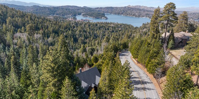
Property Detail
Blueridge Dr
Riverside-San Bernardino-Ontario, CA
W 1/2 SW 1/4 SW 1/4 SEC 23 TP 2N R 3W EX COM ON W L1 SD SEC 464.5 FT N OF SW 1/4 COR SD SEC TH N O DEG 18 M1N E 185 FT TH S 89 DEG 42 M1N E 7O FT TH S O DEG 18 M1N W 185 FT TH N 89 DEG 42 M1N W 7O FT TO POB AND EX PTN COM AT NE COR LOT 3 BLK 1 ARROWH
0331-251-07
SAN BERNARDINO
Vacantlandnec
California
LARS14M
3
D Areas with possible but undetermined flood hazards.
19.80 AC
2025
San Bernardino
2025
Inland Empire (California)
011101
NEARBY LISTINGS FOR SALE OR LEASE
-
-
View all Skyforest listings for sale on LoopNet.com
DEMOGRAPHICS near Blueridge Dr
1 mile
3 mile
5 mile
2024 Total Population
289
8,239
27,845
2029 Population
273
7,852
27,061
Pop Growth 2024-2029
(5.54%)
(4.70%)
(2.82%)
Average Age
41
44
42
2024 Total Households
107
3,334
10,371
HH Growth 2024-2029
(5.61%)
(4.80%)
(3.24%)
Median Household Inc
$80,555
$90,568
$98,064
Avg Household Size
2.70
2.40
2.60
2024 Avg HH Vehicles
2.00
2.00
2.00
Median Home Value
$399,999
$566,553
$539,115
Median Year Built
1962
1973
1970
Nearby Places
Map Layers
Map Styles
 Street
 Aerial
Transit
 Traffic
 Biking
Places
Listings with unknown addresses are not visible on the map
- Restaurants
- Banks
- Shops
- Fitness
- Groceries
PUBLIC TRANSPORTATION
AIRPORT
Ontario International
Drive
Walk
Distance
Ontario International
63 min
42.5 mi
Freight Ports
Port of Long Beach
Drive
Walk
Distance
Port of Long Beach
120 min
90.5 mi
SALE & LEASE HISTORY
LISTING DATE
SALE/LEASE

Mar 16, 2018
For Sale
Aug 13, 2024
For Sale
Nearby Properties
Address
Land Use
TOTAL SIZE
Lot Size
Zoning
Address
Land Use
TOTAL SIZE
Lot Size
Zoning
185,773 SF
15.42 AC
LACG
Address
Land Use
TOTAL SIZE
Lot Size
Zoning
160,928 SF
8.77 AC
LACG
Address
Land Use
TOTAL SIZE
Lot Size
Zoning
326,834 SF
38.56 AC
HTRC
Address
Land Use
TOTAL SIZE
Lot Size
Zoning
56,199 SF
540.40 AC
Address
Land Use
TOTAL SIZE
Lot Size
Zoning
78,044 SF
3.18 AC
LACS
Address
Land Use
TOTAL SIZE
Lot Size
Zoning
32,675 SF
91.96 AC
LARC
Address
Land Use
TOTAL SIZE
Lot Size
Zoning
34,726 SF
1.02 AC
LACG
Address
Land Use
TOTAL SIZE
Lot Size
Zoning
32,648 SF
1.44 AC
LACGSCP
Address
Land Use
TOTAL SIZE
Lot Size
Zoning
Address
Land Use
TOTAL SIZE
Lot Size
Zoning
172.99 AC
Address
Land Use
TOTAL SIZE
Lot Size
Zoning
24,570 SF
2.24 AC
LACG
Address
Land Use
TOTAL SIZE
Lot Size
Zoning
11,772 SF
0.22 AC
LACG
Address
Land Use
TOTAL SIZE
Lot Size
Zoning
Address
Land Use
TOTAL SIZE
Lot Size
Zoning
22,887 SF
19.30 AC
LARS14M
Address
Land Use
TOTAL SIZE
Lot Size
Zoning
56.70 AC
LARS14M
Address
Land Use
TOTAL SIZE
Lot Size
Zoning
22,542 SF
7.03 AC
LARS14M
Address
Land Use
TOTAL SIZE
Lot Size
Zoning
20,868 SF
68.79 AC
LASDRES
Address
Land Use
TOTAL SIZE
Lot Size
Zoning
25,759 SF
0.98 AC
LACGSCP
Address
Land Use
TOTAL SIZE
Lot Size
Zoning
3,570 SF
0.86 AC
LACS
Address
Land Use
TOTAL SIZE
Lot Size
Zoning
31,164 SF
0.82 AC
LACGSCP
Address
Land Use
TOTAL SIZE
Lot Size
Zoning
15,462 SF
0.52 AC
LACGSCP
Address
Land Use
TOTAL SIZE
Lot Size
Zoning
Address
Land Use
TOTAL SIZE
Lot Size
Zoning
20,228 SF
2.55 AC
LARS14M
Address
Land Use
TOTAL SIZE
Lot Size
Zoning
61,908 SF
0.19 AC
LACG
Address
Land Use
TOTAL SIZE
Lot Size
Zoning
2,650 SF
1.33 AC
LACG
Address
Land Use
TOTAL SIZE
Lot Size
Zoning
3.45 AC
LACGSCP
Address
Land Use
TOTAL SIZE
Lot Size
Zoning
105,000 SF
39.29 AC
LASDRES
Address
Land Use
TOTAL SIZE
Lot Size
Zoning
2,784 SF
0.70 AC
LACN
Address
Land Use
TOTAL SIZE
Lot Size
Zoning
8,501 SF
2.09 AC
LARM
Address
Land Use
TOTAL SIZE
Lot Size
Zoning
15,505 SF
5.25 AC
LARS14M
The World's #1 Commercial Real Estate Marketplace
Connect with us
© 2026 CoStar Group
The information above has been obtained from sources believed reliable. While we do not doubt its accuracy we have not verified it and make no guarantee, warranty or representation about it. It is your responsibility to independently confirm its accuracy and completeness. Any projections, opinions, assumptions, or estimates used are for example only and do not represent the current or future performance of the property. The value of this transaction to you depends on tax and other factors which should be evaluated by your tax, financial, and legal advisors. You and your advisors should conduct a careful, independent investigation of the property to determine to your satisfaction the suitability of the property for your needs.