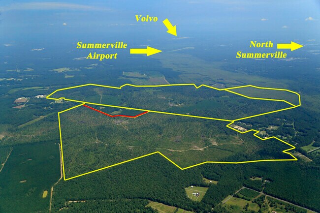
Property Record
Bobs Lake Rd, , SC
Property Detail
Bobs Lake Rd
142-00-00-015
TRACT A
Vacantlandnec
DORCHESTER
AR_DC
South Carolina
AE The base floodplain where base flood elevations are provided. AE Zones are now used on new format FIRMs instead of A1-A30 Zones.
140.92 AC
2025
Dorchester County
2025
Charleston/N Charleston
010400
Charleston-North Charleston, SC
NEARBY LISTINGS FOR SALE OR LEASE
-
-
View all listings for sale on LoopNet.com
DEMOGRAPHICS near Bobs Lake Rd
1 mile
3 mile
5 mile
2025 Total Population
217
8,377
36,953
2030 Population
240
9,236
40,852
Pop Growth 2025-2030
+ 10.60%
+ 10.25%
+ 10.55%
Average Age
41
40
39
2025 Total Households
77
2,989
13,107
HH Growth 2025-2030
+ 10.39%
+ 10.51%
+ 10.73%
Median Household Inc
$82,291
$89,758
$88,809
Avg Household Size
2.80
2.80
2.80
2025 Avg HH Vehicles
2.00
2.00
2.00
Median Home Value
$354,166
$384,310
$353,943
Median Year Built
1998
2008
2006
Nearby Places
Map Layers
Map Styles
 Street
 Aerial
Layers
 Traffic
 Biking
Places
Listings with unknown addresses are not visible on the map
- Restaurants
- Banks
- Shops
- Fitness
- Groceries
PUBLIC TRANSPORTATION
AIRPORT
Charleston AFB/International
Drive
Walk
Distance
Charleston AFB/International
31 min
18.2 mi
Freight Ports
North Charleston Terminal
Drive
Walk
Distance
North Charleston Terminal
39 min
23.1 mi
SALE & LEASE HISTORY
LISTING DATE
SALE/LEASE

Apr 02, 2020
For Sale
Nearby Properties
Address
Land Use
TOTAL SIZE
Lot Size
Zoning
Address
Land Use
TOTAL SIZE
Lot Size
Zoning
25,894 SF
19.05 AC
CG_DC
Address
Land Use
TOTAL SIZE
Lot Size
Zoning
59,600 SF
13.50 AC
I_DC
Address
Land Use
TOTAL SIZE
Lot Size
Zoning
536.07 AC
AR_DC
Address
Land Use
TOTAL SIZE
Lot Size
Zoning
308.23 AC
I_DC
Address
Land Use
TOTAL SIZE
Lot Size
Zoning
62.17 AC
PD_DC
Address
Land Use
TOTAL SIZE
Lot Size
Zoning
486.45 AC
AR_DC
Address
Land Use
TOTAL SIZE
Lot Size
Zoning
97.16 AC
MUC_DC
Address
Land Use
TOTAL SIZE
Lot Size
Zoning
118.24 AC
AR_DC
Address
Land Use
TOTAL SIZE
Lot Size
Zoning
836.14 AC
AR_DC
Address
Land Use
TOTAL SIZE
Lot Size
Zoning
838.54 AC
AR_DC
Address
Land Use
TOTAL SIZE
Lot Size
Zoning
27,514 SF
7.98 AC
PD_DC
Address
Land Use
TOTAL SIZE
Lot Size
Zoning
125.05 AC
EE
Address
Land Use
TOTAL SIZE
Lot Size
Zoning
79.40 AC
TRM_DC
Address
Land Use
TOTAL SIZE
Lot Size
Zoning
100 AC
TRM_DC
Address
Land Use
TOTAL SIZE
Lot Size
Zoning
62.98 AC
PD_DC
Address
Land Use
TOTAL SIZE
Lot Size
Zoning
12.40 AC
R-2_DC
Address
Land Use
TOTAL SIZE
Lot Size
Zoning
1,010.26 AC
MUC_DC
Address
Land Use
TOTAL SIZE
Lot Size
Zoning
54.51 AC
MUC_DC
Address
Land Use
TOTAL SIZE
Lot Size
Zoning
7,210 SF
73.50 AC
MUC_DC
Address
Land Use
TOTAL SIZE
Lot Size
Zoning
11.01 AC
SR_DC
Address
Land Use
TOTAL SIZE
Lot Size
Zoning
2.06 AC
R-1(M)_DC
Address
Land Use
TOTAL SIZE
Lot Size
Zoning
588 SF
33.65 AC
TRM_DC
Address
Land Use
TOTAL SIZE
Lot Size
Zoning
362.30 AC
MUC_DC
Address
Land Use
TOTAL SIZE
Lot Size
Zoning
50.10 AC
AR_DC
Address
Land Use
TOTAL SIZE
Lot Size
Zoning
115.77 AC
CG_DC
Address
Land Use
TOTAL SIZE
Lot Size
Zoning
365 AC
MUC_DC
Address
Land Use
TOTAL SIZE
Lot Size
Zoning
40.53 AC
PUD_SV
Address
Land Use
TOTAL SIZE
Lot Size
Zoning
4,922 SF
3.43 AC
CG_DC
Address
Land Use
TOTAL SIZE
Lot Size
Zoning
4,080 SF
0.95 AC
CG_DC
Address
Land Use
TOTAL SIZE
Lot Size
Zoning
5,000 SF
11.62 AC
CG_DC
The World's #1 Commercial Real Estate Marketplace
Connect with us
© 2026 CoStar Group
The information above has been obtained from sources believed reliable. While we do not doubt its accuracy we have not verified it and make no guarantee, warranty or representation about it. It is your responsibility to independently confirm its accuracy and completeness. Any projections, opinions, assumptions, or estimates used are for example only and do not represent the current or future performance of the property. The value of this transaction to you depends on tax and other factors which should be evaluated by your tax, financial, and legal advisors. You and your advisors should conduct a careful, independent investigation of the property to determine to your satisfaction the suitability of the property for your needs.