Property Record
Bolinger Rd, Belgrade, MT 59714

Save to a Folder
{{folder.Name}}
{{folder.ListingIds.length}} Properties
{{folder.ListingIds.length}} Property
Create a New Folder
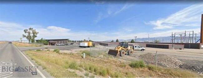
Property Detail
Bolinger Rd
Bozeman, MT
S35, T01 N, R04 E, ACRES 40, TRACT W2SW4
06-1010-35-3-05-01-0000
GALLATIN
Commercialnec
Montana
B and X Area of moderate flood hazard, usually the area between the limits of the 100-year and 500-year floods.
40 AC
2025
Bozeman/Yellowstone Country
2025
Other Market Areas
000104
NEARBY LISTINGS FOR SALE OR LEASE
DEMOGRAPHICS near Bolinger Rd
1 mile
3 mile
5 mile
2025 Total Population
7,984
21,428
24,555
2030 Population
8,458
22,294
25,486
Pop Growth 2025-2030
+ 5.94%
+ 4.04%
+ 3.79%
Average Age
36
37
37
2025 Total Households
3,081
8,059
9,249
HH Growth 2025-2030
+ 6.36%
+ 4.49%
+ 4.21%
Median Household Inc
$93,379
$95,932
$96,380
Avg Household Size
2.60
2.60
2.60
2025 Avg HH Vehicles
2.00
2.00
2.00
Median Home Value
$704,955
$652,984
$668,427
Median Year Built
2004
2003
2003
Nearby Places
Map Layers
Map Styles
 Street
 Aerial
Layers
 Traffic
 Biking
Places
Listings with unknown addresses are not visible on the map
- Restaurants
- Banks
- Shops
- Fitness
- Groceries
PUBLIC TRANSPORTATION
AIRPORT
Bozeman Yellowstone International
Drive
Walk
Distance
Bozeman Yellowstone International
9 min
3.1 mi
Freight Ports
Port of Everett
Drive
Walk
Distance
Port of Everett
735 min
689.5 mi
SALE & LEASE HISTORY
LISTING DATE
SALE/LEASE

Sep 14, 2020
For Sale
Nearby Properties
Address
Land Use
TOTAL SIZE
Lot Size
Zoning
Address
Land Use
TOTAL SIZE
Lot Size
Zoning
192,600 SF
21.65 AC
Address
Land Use
TOTAL SIZE
Lot Size
Zoning
80,640 SF
9.91 AC
Address
Land Use
TOTAL SIZE
Lot Size
Zoning
26,880 SF
4.68 AC
Address
Land Use
TOTAL SIZE
Lot Size
Zoning
33,547 SF
3.66 AC
Address
Land Use
TOTAL SIZE
Lot Size
Zoning
56,596 SF
3.08 AC
Address
Land Use
TOTAL SIZE
Lot Size
Zoning
63,462 SF
2.83 AC
Address
Land Use
TOTAL SIZE
Lot Size
Zoning
88,200 SF
21.36 AC
Address
Land Use
TOTAL SIZE
Lot Size
Zoning
20,160 SF
5 AC
Address
Land Use
TOTAL SIZE
Lot Size
Zoning
16,340 SF
20.02 AC
6
Address
Land Use
TOTAL SIZE
Lot Size
Zoning
106,700 SF
Address
Land Use
TOTAL SIZE
Lot Size
Zoning
62,417 SF
9.82 AC
Address
Land Use
TOTAL SIZE
Lot Size
Zoning
24,554 SF
Address
Land Use
TOTAL SIZE
Lot Size
Zoning
60,805 SF
Address
Land Use
TOTAL SIZE
Lot Size
Zoning
3,000 SF
15.60 AC
1
Address
Land Use
TOTAL SIZE
Lot Size
Zoning
91,640 SF
Address
Land Use
TOTAL SIZE
Lot Size
Zoning
3,600 SF
21.91 AC
Address
Land Use
TOTAL SIZE
Lot Size
Zoning
28,579 SF
8.31 AC
Address
Land Use
TOTAL SIZE
Lot Size
Zoning
20,160 SF
6.22 AC
Address
Land Use
TOTAL SIZE
Lot Size
Zoning
17,543 SF
17.23 AC
Address
Land Use
TOTAL SIZE
Lot Size
Zoning
78,361 SF
2.70 AC
Address
Land Use
TOTAL SIZE
Lot Size
Zoning
21,551 SF
1.58 AC
Address
Land Use
TOTAL SIZE
Lot Size
Zoning
8,000 SF
11.74 AC
Address
Land Use
TOTAL SIZE
Lot Size
Zoning
24,172 SF
2.29 AC
6
Address
Land Use
TOTAL SIZE
Lot Size
Zoning
42,480 SF
7.15 AC
Address
Land Use
TOTAL SIZE
Lot Size
Zoning
48,987 SF
30.90 AC
8
Address
Land Use
TOTAL SIZE
Lot Size
Zoning
47,044 SF
2.23 AC
Address
Land Use
TOTAL SIZE
Lot Size
Zoning
49,152 SF
Address
Land Use
TOTAL SIZE
Lot Size
Zoning
10,080 SF
6.40 AC
Address
Land Use
TOTAL SIZE
Lot Size
Zoning
27,004 SF
The World's #1 Commercial Real Estate Marketplace
Connect with us
© 2026 CoStar Group
The information above has been obtained from sources believed reliable. While we do not doubt its accuracy we have not verified it and make no guarantee, warranty or representation about it. It is your responsibility to independently confirm its accuracy and completeness. Any projections, opinions, assumptions, or estimates used are for example only and do not represent the current or future performance of the property. The value of this transaction to you depends on tax and other factors which should be evaluated by your tax, financial, and legal advisors. You and your advisors should conduct a careful, independent investigation of the property to determine to your satisfaction the suitability of the property for your needs.