Property Record
Bolstad Rd, Columbia, MO 65202

Save to a Folder
{{folder.Name}}
{{folder.ListingIds.length}} Properties
{{folder.ListingIds.length}} Property
Create a New Folder
Property Detail
Bolstad Rd
Columbia, MO
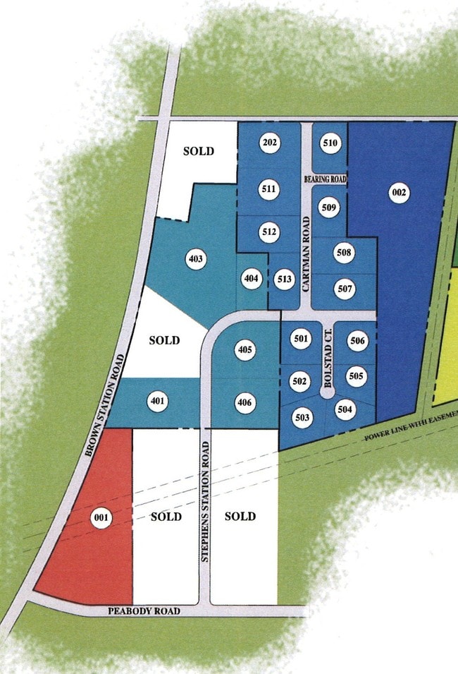
EWING INDUSTRIAL PARK PLAT 5 LOT 502
12-502-00-03-002-00-01
BOONE
Commercialnec
Missouri
MC
502
B and X Area of moderate flood hazard, usually the area between the limits of the 100-year and 500-year floods.
1.22 AC
2025
Columbia/Jefferson City
2025
Other Market Areas
001508
NEARBY LISTINGS FOR SALE OR LEASE
-
-
View all Columbia listings for sale on LoopNet.com
DEMOGRAPHICS near Bolstad Rd
1 mile
3 mile
5 mile
2025 Total Population
927
10,051
42,959
2030 Population
972
10,523
44,773
Pop Growth 2025-2030
+ 4.85%
+ 4.70%
+ 4.22%
Average Age
38
38
37
2025 Total Households
367
3,962
17,470
HH Growth 2025-2030
+ 4.90%
+ 4.80%
+ 4.34%
Median Household Inc
$83,019
$76,529
$72,439
Avg Household Size
2.40
2.40
2.40
2025 Avg HH Vehicles
2.00
2.00
2.00
Median Home Value
$255,696
$216,896
$208,288
Median Year Built
1993
1994
1995
Nearby Places
Map Layers
Map Styles
 Street
 Aerial
Layers
 Traffic
 Biking
Places
Listings with unknown addresses are not visible on the map
- Restaurants
- Banks
- Shops
- Fitness
- Groceries
PUBLIC TRANSPORTATION
AIRPORT
Columbia Regional
Drive
Walk
Distance
Columbia Regional
25 min
17.6 mi
Nearby Properties
Address
Land Use
TOTAL SIZE
Lot Size
Zoning
Address
Land Use
TOTAL SIZE
Lot Size
Zoning
12.55 AC
A1
Address
Land Use
TOTAL SIZE
Lot Size
Zoning
321,295 SF
79.83 AC
Address
Land Use
TOTAL SIZE
Lot Size
Zoning
134,760 SF
103.42 AC
Address
Land Use
TOTAL SIZE
Lot Size
Zoning
101,072 SF
Address
Land Use
TOTAL SIZE
Lot Size
Zoning
259,538 SF
26.78 AC
M1
Address
Land Use
TOTAL SIZE
Lot Size
Zoning
151,550 SF
53.69 AC
MC
Address
Land Use
TOTAL SIZE
Lot Size
Zoning
83,100 SF
14.96 AC
CP
Address
Land Use
TOTAL SIZE
Lot Size
Zoning
167,255 SF
14.14 AC
Address
Land Use
TOTAL SIZE
Lot Size
Zoning
5,200 SF
11 AC
M1
Address
Land Use
TOTAL SIZE
Lot Size
Zoning
60,000 SF
6.91 AC
Address
Land Use
TOTAL SIZE
Lot Size
Zoning
172,056 SF
31.81 AC
MC
Address
Land Use
TOTAL SIZE
Lot Size
Zoning
58,200 SF
14.68 AC
MC
Address
Land Use
TOTAL SIZE
Lot Size
Zoning
21,120 SF
7.71 AC
Address
Land Use
TOTAL SIZE
Lot Size
Zoning
80,256 SF
10.10 AC
M1
Address
Land Use
TOTAL SIZE
Lot Size
Zoning
20,740 SF
2.75 AC
MC
Address
Land Use
TOTAL SIZE
Lot Size
Zoning
45,144 SF
19.47 AC
M1
Address
Land Use
TOTAL SIZE
Lot Size
Zoning
17,066 SF
12 AC
M1
Address
Land Use
TOTAL SIZE
Lot Size
Zoning
23,945 SF
7.51 AC
MLP
Address
Land Use
TOTAL SIZE
Lot Size
Zoning
31,000 SF
8.90 AC
M1
Address
Land Use
TOTAL SIZE
Lot Size
Zoning
51,615 SF
6.25 AC
Address
Land Use
TOTAL SIZE
Lot Size
Zoning
31,925 SF
3.29 AC
Address
Land Use
TOTAL SIZE
Lot Size
Zoning
45,000 SF
4.08 AC
M1
Address
Land Use
TOTAL SIZE
Lot Size
Zoning
22,500 SF
2.39 AC
M1
Address
Land Use
TOTAL SIZE
Lot Size
Zoning
17,870 SF
8.66 AC
M1
Address
Land Use
TOTAL SIZE
Lot Size
Zoning
4,980 SF
1.04 AC
R3
Address
Land Use
TOTAL SIZE
Lot Size
Zoning
18,200 SF
3.65 AC
Address
Land Use
TOTAL SIZE
Lot Size
Zoning
16,200 SF
7.18 AC
M1
Address
Land Use
TOTAL SIZE
Lot Size
Zoning
26,825 SF
13.20 AC
CGP
Address
Land Use
TOTAL SIZE
Lot Size
Zoning
19,038 SF
3.04 AC
Address
Land Use
TOTAL SIZE
Lot Size
Zoning
14,640 SF
3.19 AC
The World's #1 Commercial Real Estate Marketplace
Connect with us
© 2026 CoStar Group
The information above has been obtained from sources believed reliable. While we do not doubt its accuracy we have not verified it and make no guarantee, warranty or representation about it. It is your responsibility to independently confirm its accuracy and completeness. Any projections, opinions, assumptions, or estimates used are for example only and do not represent the current or future performance of the property. The value of this transaction to you depends on tax and other factors which should be evaluated by your tax, financial, and legal advisors. You and your advisors should conduct a careful, independent investigation of the property to determine to your satisfaction the suitability of the property for your needs.