Property Record
73 Bonbrook Mill Rd, Rocky Mount, VA 24151


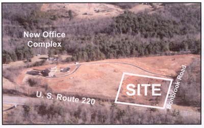

Property Detail
73 Bonbrook Mill Rd
0440015801
RT 635
Officebuilding
FRANKLIN
B2
Virginia
B and X Area of moderate flood hazard, usually the area between the limits of the 100-year and 500-year floods.
2.42 AC
2025
North Franklin County
2025
Roanoke
020400
Roanoke, VA
8,640 SF
NEARBY LISTINGS FOR SALE OR LEASE
-
-
View all Rocky Mount listings for sale on LoopNet.com
DEMOGRAPHICS near 73 Bonbrook Mill Rd
1 mile
3 mile
5 mile
2025 Total Population
743
4,087
12,328
2030 Population
731
4,026
12,177
Pop Growth 2025-2030
(1.62%)
(1.49%)
(1.22%)
Average Age
42
42
42
2025 Total Households
309
1,705
5,151
HH Growth 2025-2030
(1.94%)
(1.70%)
(1.48%)
Median Household Inc
$81,111
$74,125
$63,632
Avg Household Size
2.40
2.40
2.30
2025 Avg HH Vehicles
2.00
2.00
2.00
Median Home Value
$234,127
$228,488
$210,619
Median Year Built
1982
1982
1979
Nearby Places
Map Layers
Map Styles
 Street
 Aerial
Layers
 Traffic
 Biking
Places
Listings with unknown addresses are not visible on the map
- Restaurants
- Banks
- Shops
- Fitness
- Groceries
PUBLIC TRANSPORTATION
AIRPORT
Roanoke/Blacksburg Regional (Woodrum Field)
Drive
Walk
Distance
Roanoke/Blacksburg Regional (Woodrum Field)
35 min
25.5 mi
Freight Ports
Virginia Port Authority - Richmond
Drive
Walk
Distance
Virginia Port Authority - Richmond
231 min
166.6 mi
Nearby Properties
Address
Land Use
TOTAL SIZE
Lot Size
Zoning
Address
Land Use
TOTAL SIZE
Lot Size
Zoning
48,658 SF
7.91 AC
B2
Address
Land Use
TOTAL SIZE
Lot Size
Zoning
730,076 SF
55.36 AC
SM
Address
Land Use
TOTAL SIZE
Lot Size
Zoning
1,507 SF
285.58 AC
REP
Address
Land Use
TOTAL SIZE
Lot Size
Zoning
61,498 SF
12.67 AC
R1
Address
Land Use
TOTAL SIZE
Lot Size
Zoning
117,720 SF
7.62 AC
SM
Address
Land Use
TOTAL SIZE
Lot Size
Zoning
44,994 SF
15 AC
POS
Address
Land Use
TOTAL SIZE
Lot Size
Zoning
21,012 SF
8.60 AC
REP
Address
Land Use
TOTAL SIZE
Lot Size
Zoning
6,760 SF
2.75 AC
SM
Address
Land Use
TOTAL SIZE
Lot Size
Zoning
14.54 AC
A1
Address
Land Use
TOTAL SIZE
Lot Size
Zoning
22,638 SF
2.41 AC
PCD
Address
Land Use
TOTAL SIZE
Lot Size
Zoning
59,000 SF
13.73 AC
B2
Address
Land Use
TOTAL SIZE
Lot Size
Zoning
19,124 SF
2.87 AC
C1
Address
Land Use
TOTAL SIZE
Lot Size
Zoning
2,036 SF
90.40 AC
REP
Address
Land Use
TOTAL SIZE
Lot Size
Zoning
31,204 SF
2.76 AC
SM
Address
Land Use
TOTAL SIZE
Lot Size
Zoning
1,718 SF
105.31 AC
REP
Address
Land Use
TOTAL SIZE
Lot Size
Zoning
51,280 SF
5.64 AC
B2
Address
Land Use
TOTAL SIZE
Lot Size
Zoning
10,669 SF
13.38 AC
SM
Address
Land Use
TOTAL SIZE
Lot Size
Zoning
36,290 SF
3.04 AC
GB
Address
Land Use
TOTAL SIZE
Lot Size
Zoning
16,304 SF
8 AC
B2
Address
Land Use
TOTAL SIZE
Lot Size
Zoning
40,275 SF
1.90 AC
B2
Address
Land Use
TOTAL SIZE
Lot Size
Zoning
50,400 SF
8.89 AC
REP
Address
Land Use
TOTAL SIZE
Lot Size
Zoning
16,200 SF
3.45 AC
Address
Land Use
TOTAL SIZE
Lot Size
Zoning
38,920 SF
2.30 AC
B2
Address
Land Use
TOTAL SIZE
Lot Size
Zoning
15,856 SF
16.48 AC
B2
Address
Land Use
TOTAL SIZE
Lot Size
Zoning
12,469 SF
1.80 AC
PCD
Address
Land Use
TOTAL SIZE
Lot Size
Zoning
7,032 SF
4.08 AC
R3
Address
Land Use
TOTAL SIZE
Lot Size
Zoning
9,220 SF
2.43 AC
B2
Address
Land Use
TOTAL SIZE
Lot Size
Zoning
21,600 SF
3.79 AC
GB
Address
Land Use
TOTAL SIZE
Lot Size
Zoning
9,504 SF
2.89 AC
R3
Address
Land Use
TOTAL SIZE
Lot Size
Zoning
22,050 SF
5.90 AC
A1
The World's #1 Commercial Real Estate Marketplace
Connect with us
© 2026 CoStar Group
The information above has been obtained from sources believed reliable. While we do not doubt its accuracy we have not verified it and make no guarantee, warranty or representation about it. It is your responsibility to independently confirm its accuracy and completeness. Any projections, opinions, assumptions, or estimates used are for example only and do not represent the current or future performance of the property. The value of this transaction to you depends on tax and other factors which should be evaluated by your tax, financial, and legal advisors. You and your advisors should conduct a careful, independent investigation of the property to determine to your satisfaction the suitability of the property for your needs.