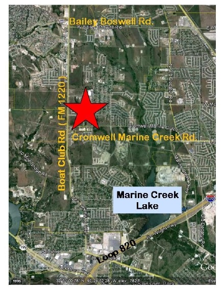
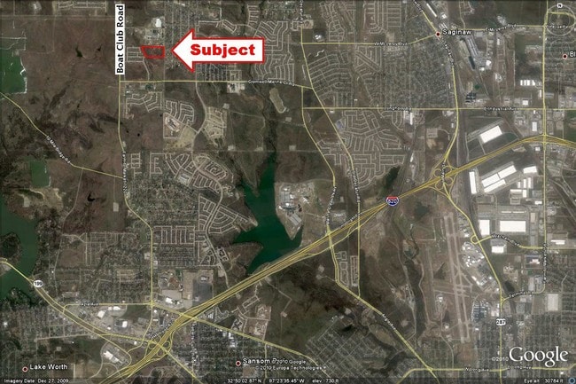
Property Record
5953 Bowman Roberts Rd, Fort Worth, TX 76179

Property Detail
5953 Bowman Roberts Rd
Dallas-Fort Worth-Arlington, TX
SAINT THOMAS THE APOSTLE ADDITION BLOCK 1 LOT 1 LESS EXEMPTION WITH AG
42132817
TARRANT
Commercialnec
Texas
B and X Area of moderate flood hazard, usually the area between the limits of the 100-year and 500-year floods.
1
0
16.13 AC
2025
Northwest Ft Worth
114011
Dallas/Ft Worth
33,133 SF
NEARBY LISTINGS FOR SALE OR LEASE
DEMOGRAPHICS near 5953 Bowman Roberts Rd
1 mile
3 mile
5 mile
2025 Total Population
12,811
76,510
152,871
2030 Population
13,693
81,395
163,636
Pop Growth 2025-2030
+ 6.88%
+ 6.38%
+ 7.04%
Average Age
34
36
36
2025 Total Households
3,889
25,128
49,798
HH Growth 2025-2030
+ 7.07%
+ 6.47%
+ 7.08%
Median Household Inc
$122,011
$102,293
$91,665
Avg Household Size
3.20
3.00
3.00
2025 Avg HH Vehicles
2.00
2.00
2.00
Median Home Value
$325,773
$324,646
$326,357
Median Year Built
2009
2004
2003
Nearby Places
Map Layers
Map Styles
 Street
 Aerial
Layers
 Traffic
 Biking
Places
Listings with unknown addresses are not visible on the map
- Restaurants
- Banks
- Shops
- Fitness
- Groceries
PUBLIC TRANSPORTATION
AIRPORT
Dallas-Fort Worth International
Drive
Walk
Distance
Dallas-Fort Worth International
42 min
28.7 mi
Freight Ports
Port of Shreveport
Drive
Walk
Distance
Port of Shreveport
263 min
236.6 mi
Nearby Properties
Address
Land Use
TOTAL SIZE
Lot Size
Zoning
Address
Land Use
TOTAL SIZE
Lot Size
Zoning
431,028 SF
126.62 AC
Address
Land Use
TOTAL SIZE
Lot Size
Zoning
307,139 SF
14.02 AC
Address
Land Use
TOTAL SIZE
Lot Size
Zoning
342,456 SF
15.56 AC
Address
Land Use
TOTAL SIZE
Lot Size
Zoning
531,597 SF
31.71 AC
Address
Land Use
TOTAL SIZE
Lot Size
Zoning
290,034 SF
11.04 AC
Address
Land Use
TOTAL SIZE
Lot Size
Zoning
456,866 SF
94.57 AC
Address
Land Use
TOTAL SIZE
Lot Size
Zoning
293,830 SF
14.90 AC
Address
Land Use
TOTAL SIZE
Lot Size
Zoning
341,646 SF
17.63 AC
Address
Land Use
TOTAL SIZE
Lot Size
Zoning
225,140 SF
11.68 AC
Address
Land Use
TOTAL SIZE
Lot Size
Zoning
254,610 SF
15.92 AC
Address
Land Use
TOTAL SIZE
Lot Size
Zoning
207,044 SF
11.48 AC
Address
Land Use
TOTAL SIZE
Lot Size
Zoning
319,219 SF
13.43 AC
Address
Land Use
TOTAL SIZE
Lot Size
Zoning
284,422 SF
119.90 AC
Address
Land Use
TOTAL SIZE
Lot Size
Zoning
219,007 SF
10.91 AC
Address
Land Use
TOTAL SIZE
Lot Size
Zoning
127,261 SF
83.50 AC
Address
Land Use
TOTAL SIZE
Lot Size
Zoning
184,765 SF
18.92 AC
Address
Land Use
TOTAL SIZE
Lot Size
Zoning
210,576 SF
10 AC
Address
Land Use
TOTAL SIZE
Lot Size
Zoning
184,919 SF
9.81 AC
Address
Land Use
TOTAL SIZE
Lot Size
Zoning
126,885 SF
10.55 AC
Address
Land Use
TOTAL SIZE
Lot Size
Zoning
94,566 SF
11.90 AC
Address
Land Use
TOTAL SIZE
Lot Size
Zoning
132,210 SF
26.77 AC
Address
Land Use
TOTAL SIZE
Lot Size
Zoning
60,000 SF
9.92 AC
Address
Land Use
TOTAL SIZE
Lot Size
Zoning
153,000 SF
27.52 AC
Address
Land Use
TOTAL SIZE
Lot Size
Zoning
89,111 SF
26.79 AC
Address
Land Use
TOTAL SIZE
Lot Size
Zoning
258,600 SF
18.78 AC
Address
Land Use
TOTAL SIZE
Lot Size
Zoning
264,125 SF
16.25 AC
Address
Land Use
TOTAL SIZE
Lot Size
Zoning
237,301 SF
8 AC
Address
Land Use
TOTAL SIZE
Lot Size
Zoning
182,063 SF
10.73 AC
Address
Land Use
TOTAL SIZE
Lot Size
Zoning
105,255 SF
8.10 AC
Address
Land Use
TOTAL SIZE
Lot Size
Zoning
72,872 SF
14.39 AC
The World's #1 Commercial Real Estate Marketplace
Connect with us
© 2026 CoStar Group
The information above has been obtained from sources believed reliable. While we do not doubt its accuracy we have not verified it and make no guarantee, warranty or representation about it. It is your responsibility to independently confirm its accuracy and completeness. Any projections, opinions, assumptions, or estimates used are for example only and do not represent the current or future performance of the property. The value of this transaction to you depends on tax and other factors which should be evaluated by your tax, financial, and legal advisors. You and your advisors should conduct a careful, independent investigation of the property to determine to your satisfaction the suitability of the property for your needs.