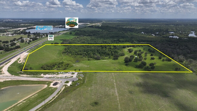
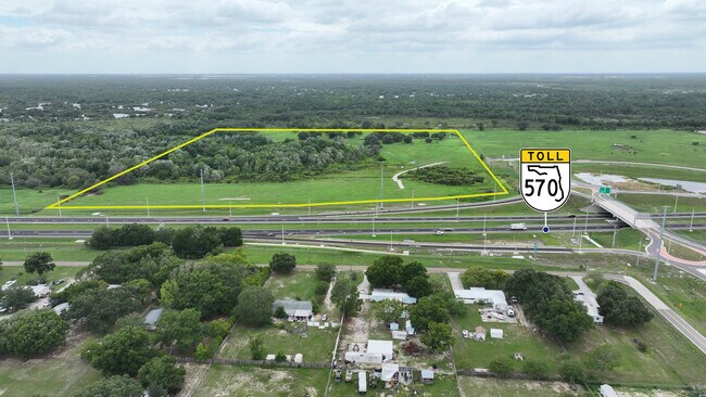
Property Record
Braddock Rd, Auburndale, FL 33823
Property Detail
Braddock Rd
25-27-29-000000-044010
SE1/4 OF SW1/4 LESS N 25 FT FOR RD & LESS R/W FOR SR 570 AS REC IN OR 3844 PG 698 & LESS ADDL R/W FOR SR 570 AS REC IN OR 10800 PG 1629
Pasture
POLK
RC
Florida
A Areas with a 1% annual chance of flooding and a 26% chance of flooding over the life of a 30-year mortgage.
17.02 AC
2024
Polk County
2025
Tampa/St Petersburg
013102
Lakeland-Winter Haven, FL
NEARBY LISTINGS FOR SALE OR LEASE
-
-
View all Auburndale listings for sale on LoopNet.com
DEMOGRAPHICS near Braddock Rd
1 mile
3 mile
5 mile
2025 Total Population
464
17,895
55,894
2030 Population
533
20,534
64,420
Pop Growth 2025-2030
+ 14.87%
+ 14.75%
+ 15.25%
Average Age
41
41
42
2025 Total Households
163
6,743
21,181
HH Growth 2025-2030
+ 14.72%
+ 15.01%
+ 15.54%
Median Household Inc
$97,684
$81,038
$71,415
Avg Household Size
2.80
2.60
2.60
2025 Avg HH Vehicles
2.00
2.00
2.00
Median Home Value
$360,638
$325,887
$300,468
Median Year Built
1998
1995
1993
Nearby Places
Map Layers
Map Styles
 Street
 Aerial
Transit
 Traffic
 Biking
Places
Listings with unknown addresses are not visible on the map
- Restaurants
- Banks
- Shops
- Fitness
- Groceries
SALE & LEASE HISTORY
LISTING DATE
SALE/LEASE

Sep 21, 2023
For Sale
Nearby Properties
Address
Land Use
TOTAL SIZE
Lot Size
Zoning
Address
Land Use
TOTAL SIZE
Lot Size
Zoning
831,600 SF
51.22 AC
Address
Land Use
TOTAL SIZE
Lot Size
Zoning
811,392 SF
47.70 AC
Address
Land Use
TOTAL SIZE
Lot Size
Zoning
463,500 SF
27.88 AC
Address
Land Use
TOTAL SIZE
Lot Size
Zoning
275,220 SF
94.53 AC
Address
Land Use
TOTAL SIZE
Lot Size
Zoning
160,755 SF
9.94 AC
Address
Land Use
TOTAL SIZE
Lot Size
Zoning
50,128 SF
4.96 AC
Address
Land Use
TOTAL SIZE
Lot Size
Zoning
75.70 AC
RC
Address
Land Use
TOTAL SIZE
Lot Size
Zoning
90,220 SF
26.99 AC
Address
Land Use
TOTAL SIZE
Lot Size
Zoning
30,568 SF
60.79 AC
RC
Address
Land Use
TOTAL SIZE
Lot Size
Zoning
77,279 SF
12.12 AC
Address
Land Use
TOTAL SIZE
Lot Size
Zoning
54,204 SF
9.09 AC
Address
Land Use
TOTAL SIZE
Lot Size
Zoning
20,038 SF
7.92 AC
Address
Land Use
TOTAL SIZE
Lot Size
Zoning
12,988 SF
16.11 AC
Address
Land Use
TOTAL SIZE
Lot Size
Zoning
12,464 SF
83.69 AC
RC
Address
Land Use
TOTAL SIZE
Lot Size
Zoning
22,296 SF
9.90 AC
R1
Address
Land Use
TOTAL SIZE
Lot Size
Zoning
15,625 SF
3.35 AC
R1
Address
Land Use
TOTAL SIZE
Lot Size
Zoning
3,804 SF
4.26 AC
RC
Address
Land Use
TOTAL SIZE
Lot Size
Zoning
12,940 SF
0.76 AC
Address
Land Use
TOTAL SIZE
Lot Size
Zoning
15.88 AC
R3
Address
Land Use
TOTAL SIZE
Lot Size
Zoning
5,986 SF
19.97 AC
RC
Address
Land Use
TOTAL SIZE
Lot Size
Zoning
159.60 AC
Address
Land Use
TOTAL SIZE
Lot Size
Zoning
5,465 SF
568.30 AC
RC
Address
Land Use
TOTAL SIZE
Lot Size
Zoning
9,476 SF
1.10 AC
R2
Address
Land Use
TOTAL SIZE
Lot Size
Zoning
158.83 AC
Address
Land Use
TOTAL SIZE
Lot Size
Zoning
37,861 SF
4.23 AC
LI
Address
Land Use
TOTAL SIZE
Lot Size
Zoning
897,300 SF
4.28 AC
R3
Address
Land Use
TOTAL SIZE
Lot Size
Zoning
9,142 SF
1.50 AC
Address
Land Use
TOTAL SIZE
Lot Size
Zoning
35.50 AC
Address
Land Use
TOTAL SIZE
Lot Size
Zoning
22,096 SF
1.17 AC
XX
Address
Land Use
TOTAL SIZE
Lot Size
Zoning
6.86 AC
The World's #1 Commercial Real Estate Marketplace
Connect with us
© 2026 CoStar Group
The information above has been obtained from sources believed reliable. While we do not doubt its accuracy we have not verified it and make no guarantee, warranty or representation about it. It is your responsibility to independently confirm its accuracy and completeness. Any projections, opinions, assumptions, or estimates used are for example only and do not represent the current or future performance of the property. The value of this transaction to you depends on tax and other factors which should be evaluated by your tax, financial, and legal advisors. You and your advisors should conduct a careful, independent investigation of the property to determine to your satisfaction the suitability of the property for your needs.