Property Record
Bradley Rd, Colorado Springs, CO 80925


Save to a Folder
{{folder.Name}}
{{folder.ListingIds.length}} Properties
{{folder.ListingIds.length}} Property
Create a New Folder
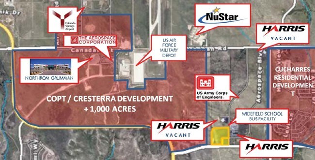
Property Detail
Bradley Rd
Colorado Springs, CO
LOT 5 COLORADO CENTRE FOREIGN TRADE ZONE & BUSINESS PARK FIL NO 1
55091-01-002
EL PASO
Commercialacreage
Colorado
CC
5
B and X Area of moderate flood hazard, usually the area between the limits of the 100-year and 500-year floods.
4.83 AC
0
Southeast
2026
Colorado Springs
004518
NEARBY LISTINGS FOR SALE OR LEASE
-
-
-
NEC & SEC Marksheffel Rd & Fontaine Blvd
Colorado Springs, CO 80925
Rent Upon Request
0.75 - 4.68 AC Lot
Land
-
-
-
-
View all Colorado Springs listings for sale on LoopNet.com
DEMOGRAPHICS near Bradley Rd
1 mile
3 mile
5 mile
2025 Total Population
2,874
28,848
91,331
2030 Population
3,129
29,899
93,474
Pop Growth 2025-2030
+ 8.87%
+ 3.64%
+ 2.35%
Average Age
33
34
34
2025 Total Households
895
9,152
30,026
HH Growth 2025-2030
+ 9.05%
+ 3.80%
+ 2.47%
Median Household Inc
$121,114
$103,611
$89,898
Avg Household Size
3.20
3.10
3.00
2025 Avg HH Vehicles
2.00
2.00
2.00
Median Home Value
$494,146
$451,620
$401,127
Median Year Built
2010
2009
1995
Nearby Places
Map Layers
Map Styles
 Street
 Aerial
Layers
 Traffic
 Biking
Places
Listings with unknown addresses are not visible on the map
- Restaurants
- Banks
- Shops
- Fitness
- Groceries
PUBLIC TRANSPORTATION
AIRPORT
City of Colorado Springs Municipal
Drive
Walk
Distance
City of Colorado Springs Municipal
14 min
7.4 mi
Freight Ports
Tulsa Port Of Catoosa
Drive
Walk
Distance
Tulsa Port Of Catoosa
737 min
696.6 mi
Nearby Properties
Address
Land Use
TOTAL SIZE
Lot Size
Zoning
Address
Land Use
TOTAL SIZE
Lot Size
Zoning
3,486,127 SF
69.25 AC
APD APZ1 A
Address
Land Use
TOTAL SIZE
Lot Size
Zoning
241,806 SF
937.06 AC
A-5 CAD-O
Address
Land Use
TOTAL SIZE
Lot Size
Zoning
89,487 SF
Address
Land Use
TOTAL SIZE
Lot Size
Zoning
37,865 SF
9.44 AC
PDZ AO SS
Address
Land Use
TOTAL SIZE
Lot Size
Zoning
78,815 SF
Address
Land Use
TOTAL SIZE
Lot Size
Zoning
278,331 SF
324.19 AC
Address
Land Use
TOTAL SIZE
Lot Size
Zoning
20.82 AC
APD APZ1 A
Address
Land Use
TOTAL SIZE
Lot Size
Zoning
130,569 SF
3.23 AC
Address
Land Use
TOTAL SIZE
Lot Size
Zoning
43,914 SF
9.36 AC
A-5 CAD-O
Address
Land Use
TOTAL SIZE
Lot Size
Zoning
168.20 AC
APD APZ1 A
Address
Land Use
TOTAL SIZE
Lot Size
Zoning
278,331 SF
6.39 AC
Address
Land Use
TOTAL SIZE
Lot Size
Zoning
84,750 SF
7.68 AC
Address
Land Use
TOTAL SIZE
Lot Size
Zoning
12.69 AC
APD RPZ AO
Address
Land Use
TOTAL SIZE
Lot Size
Zoning
278,331 SF
108.87 AC
APD AO APZ
Address
Land Use
TOTAL SIZE
Lot Size
Zoning
77,486 SF
6.39 AC
I-2 CAD-O
Address
Land Use
TOTAL SIZE
Lot Size
Zoning
66,780 SF
18.74 AC
APD APZ2 A
Address
Land Use
TOTAL SIZE
Lot Size
Zoning
471.26 AC
APD APZ2 A
Address
Land Use
TOTAL SIZE
Lot Size
Zoning
46,756 SF
5.02 AC
I-2 CAD-O
Address
Land Use
TOTAL SIZE
Lot Size
Zoning
5,651 SF
5 AC
NC
Address
Land Use
TOTAL SIZE
Lot Size
Zoning
14.21 AC
APD APZ2 A
Address
Land Use
TOTAL SIZE
Lot Size
Zoning
12,150 SF
1.21 AC
CS CAD-O
Address
Land Use
TOTAL SIZE
Lot Size
Zoning
12.99 AC
BP/CR AO
Address
Land Use
TOTAL SIZE
Lot Size
Zoning
646.94 AC
A-5 CAD-O
Address
Land Use
TOTAL SIZE
Lot Size
Zoning
8,142 SF
7.73 AC
RS-5000 CA
Address
Land Use
TOTAL SIZE
Lot Size
Zoning
106.88 AC
APD AO
Address
Land Use
TOTAL SIZE
Lot Size
Zoning
278 SF
46.82 AC
APD APZ1 A
Address
Land Use
TOTAL SIZE
Lot Size
Zoning
90,545 SF
5.02 AC
PUD CAD-O
Address
Land Use
TOTAL SIZE
Lot Size
Zoning
320 AC
A-5 CAD-O
Address
Land Use
TOTAL SIZE
Lot Size
Zoning
23,285 SF
4.53 AC
A-5 CAD-O
Address
Land Use
TOTAL SIZE
Lot Size
Zoning
42,984 SF
10 AC
I-2 CAD-O
The World's #1 Commercial Real Estate Marketplace
Connect with us
© 2026 CoStar Group
The information above has been obtained from sources believed reliable. While we do not doubt its accuracy we have not verified it and make no guarantee, warranty or representation about it. It is your responsibility to independently confirm its accuracy and completeness. Any projections, opinions, assumptions, or estimates used are for example only and do not represent the current or future performance of the property. The value of this transaction to you depends on tax and other factors which should be evaluated by your tax, financial, and legal advisors. You and your advisors should conduct a careful, independent investigation of the property to determine to your satisfaction the suitability of the property for your needs.