Property Record
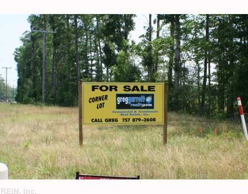
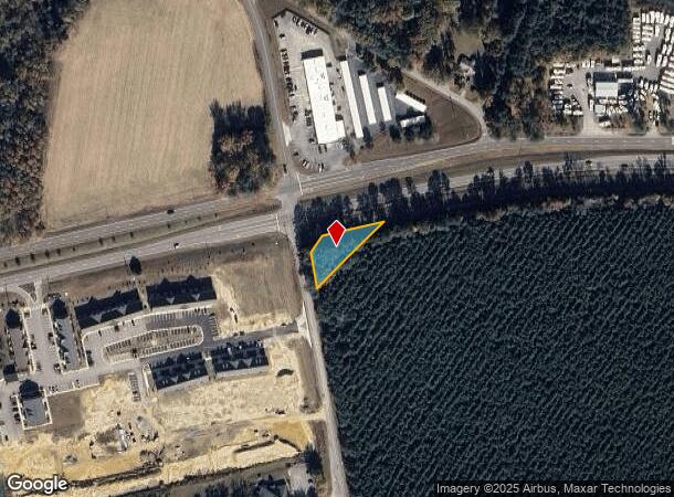
Brewers Neck Blvd, Carrollton, VA 23314
NEARBY LISTINGS FOR SALE OR LEASE
Property Detail
Brewers Neck Blvd
33-01-166B
ON RASCOE NECK
Residentialacreage
Isle of Wight
X
Virginia
51093C0158E
0.34 AC
2025
Isle Of Wight
2025
Hampton Roads
280108
Virginia Beach-Norfolk-Newport News, VA-NC
DEMOGRAPHICS near Brewers Neck Blvd
1 Mile
3 Mile
5 Mile
2024 Total Population
542
13,412
25,501
2029 Population
589
14,666
27,909
Pop Growth 2024-2029
+ 8.67%
+ 9.35%
+ 9.44%
Average Age
43
41
43
2024 Total Households
221
5,139
9,894
HH Growth 2024-2029
+ 8.60%
+ 9.18%
+ 9.38%
Median Household Inc
$120,564
$104,620
$107,845
Avg Household Size
2.40
2.60
2.50
2024 Avg HH Vehicles
2.00
2.00
2.00
Median Home Value
$353,676
$373,910
$371,126
Median Year Built
1995
1998
1993
Nearby Places
Map Layers
Map Styles
 Street
 Aerial
- Restaurants
- Banks
- Shops
- Fitness
- Groceries
PUBLIC TRANSPORTATION
COMMUTER RAIL
Newport News (Northeast Regional - Amtrak)
DRIVE
WALK
Distance
Newport News (Northeast Regional - Amtrak)
13 min
8.9 mi
AIRPORT
Newport News/Williamsburg International
DRIVE
WALK
Distance
Newport News/Williamsburg International
31 min
18.1 mi
Norfolk International
DRIVE
WALK
Distance
Norfolk International
43 min
25.8 mi
Freight Ports
Virginia Port Authority - Newport News
DRIVE
WALK
Distance
Virginia Port Authority - Newport News
19 min
11.4 mi
Nearby Properties
Address
Land Use
TOTAL SIZE
Lot Size
Zoning
Address
Land Use
TOTAL SIZE
Lot Size
Zoning
79.87 AC
RAC
Address
Land Use
TOTAL SIZE
Lot Size
Zoning
27,718 SF
18.75 AC
Address
Land Use
TOTAL SIZE
Lot Size
Zoning
9,600 SF
17.35 AC
PDR
Address
Land Use
TOTAL SIZE
Lot Size
Zoning
3,998 SF
15.79 AC
01
Address
Land Use
TOTAL SIZE
Lot Size
Zoning
13,368 SF
19.96 AC
PDR
Address
Land Use
TOTAL SIZE
Lot Size
Zoning
51,086 SF
43.12 AC
01
Address
Land Use
TOTAL SIZE
Lot Size
Zoning
99,606 SF
34.89 AC
RAC
Address
Land Use
TOTAL SIZE
Lot Size
Zoning
77,001 SF
13.97 AC
01
Address
Land Use
TOTAL SIZE
Lot Size
Zoning
52,944 SF
9.67 AC
TOWN
Address
Land Use
TOTAL SIZE
Lot Size
Zoning
35.19 AC
01
Address
Land Use
TOTAL SIZE
Lot Size
Zoning
26,471 SF
29.55 AC
01
Address
Land Use
TOTAL SIZE
Lot Size
Zoning
57,513 SF
11.37 AC
Address
Land Use
TOTAL SIZE
Lot Size
Zoning
58,368 SF
2.51 AC
TOWN
Address
Land Use
TOTAL SIZE
Lot Size
Zoning
22,750 SF
19.51 AC
RAC
Address
Land Use
TOTAL SIZE
Lot Size
Zoning
99.89 AC
01
Address
Land Use
TOTAL SIZE
Lot Size
Zoning
13,512 SF
8.07 AC
TOWN
Address
Land Use
TOTAL SIZE
Lot Size
Zoning
1,018 SF
8.03 AC
GC
Address
Land Use
TOTAL SIZE
Lot Size
Zoning
15,600 SF
5.09 AC
TOWN
Address
Land Use
TOTAL SIZE
Lot Size
Zoning
4,900 SF
1.17 AC
Address
Land Use
TOTAL SIZE
Lot Size
Zoning
3,236 SF
55.59 AC
01
Address
Land Use
TOTAL SIZE
Lot Size
Zoning
25,200 SF
4.71 AC
01
Address
Land Use
TOTAL SIZE
Lot Size
Zoning
45,170 SF
3.05 AC
TOWN
Address
Land Use
TOTAL SIZE
Lot Size
Zoning
11,187 SF
2.74 AC
01
Address
Land Use
TOTAL SIZE
Lot Size
Zoning
19,120 SF
3.65 AC
TOWN
Address
Land Use
TOTAL SIZE
Lot Size
Zoning
2,541 SF
10.93 AC
07
Address
Land Use
TOTAL SIZE
Lot Size
Zoning
7,127 SF
22.64 AC
TOWN
Address
Land Use
TOTAL SIZE
Lot Size
Zoning
13,460 SF
3.47 AC
TOWN
Address
Land Use
TOTAL SIZE
Lot Size
Zoning
14,790 SF
3.28 AC
TOWN
Address
Land Use
TOTAL SIZE
Lot Size
Zoning
4,744 SF
5.11 AC
Address
Land Use
TOTAL SIZE
Lot Size
Zoning
110 AC
RAC
The World's #1 Commercial Real Estate Marketplace
Connect with us
© 2025 CoStar Group
The information above has been obtained from sources believed reliable. While we do not doubt its accuracy we have not verified it and make no guarantee, warranty or representation about it. It is your responsibility to independently confirm its accuracy and completeness. Any projections, opinions, assumptions, or estimates used are for example only and do not represent the current or future performance of the property. The value of this transaction to you depends on tax and other factors which should be evaluated by your tax, financial, and legal advisors. You and your advisors should conduct a careful, independent investigation of the property to determine to your satisfaction the suitability of the property for your needs.