Property Record
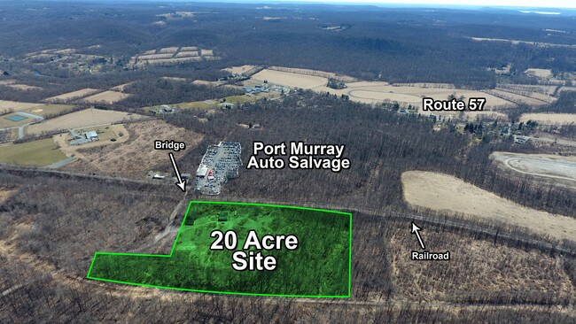
Brickyard Rd, Mansfield, NJ 08022


Property Detail
Brickyard Rd
16-00702-0000-00004
WARREN
Industrialgeneral
New Jersey
B and X Area of moderate flood hazard, usually the area between the limits of the 100-year and 500-year floods.
4
2024
20.87 AC
2025
Warren County
701401
Northern New Jersey
3,536 SF
Allentown-Bethlehem-Easton, PA-NJ
NEARBY LISTINGS FOR SALE OR LEASE
-
-
View all Mansfield listings for sale on LoopNet.com
DEMOGRAPHICS near Brickyard Rd
1 mile
3 mile
5 mile
2025 Total Population
627
6,259
26,924
2030 Population
659
6,443
27,477
Pop Growth 2025-2030
+ 5.10%
+ 2.94%
+ 2.05%
Average Age
45
44
44
2025 Total Households
237
2,332
10,283
HH Growth 2025-2030
+ 4.64%
+ 2.96%
+ 1.97%
Median Household Inc
$92,321
$105,433
$112,837
Avg Household Size
2.70
2.60
2.60
2025 Avg HH Vehicles
2.00
2.00
2.00
Median Home Value
$328,750
$376,997
$375,608
Median Year Built
1965
1970
1971
Nearby Places
Map Layers
Map Styles
 Street
 Aerial
Layers
 Traffic
 Biking
Places
Listings with unknown addresses are not visible on the map
- Restaurants
- Banks
- Shops
- Fitness
- Groceries
PUBLIC TRANSPORTATION
COMMUTER RAIL
Hackettstown (Montclair-Boonton Line - NJ Transit Commuter Rail (NJ Transit), Morris & Essex Morristown Line - NJ Transit Commuter Rail (NJ Transit))
Drive
Walk
Distance
Hackettstown (Montclair-Boonton Line - NJ Transit Commuter Rail (NJ Transit), Morris & Essex Morristown Line - NJ Transit Commuter Rail (NJ Transit))
16 min
7.5 mi
AIRPORT
Lehigh Valley International
Drive
Walk
Distance
Lehigh Valley International
56 min
32.6 mi
Freight Ports
New York Container Terminal
Drive
Walk
Distance
New York Container Terminal
81 min
59.5 mi
SALE & LEASE HISTORY
LISTING DATE
SALE/LEASE

Apr 11, 2019
For Sale
Nearby Properties
Address
Land Use
TOTAL SIZE
Lot Size
Zoning
Address
Land Use
TOTAL SIZE
Lot Size
Zoning
226,375 SF
50.41 AC
Address
Land Use
TOTAL SIZE
Lot Size
Zoning
73,058 SF
19.68 AC
Address
Land Use
TOTAL SIZE
Lot Size
Zoning
26,281 SF
105 AC
RC
Address
Land Use
TOTAL SIZE
Lot Size
Zoning
877.15 AC
Address
Land Use
TOTAL SIZE
Lot Size
Zoning
66.80 AC
RC
Address
Land Use
TOTAL SIZE
Lot Size
Zoning
12,448 SF
2 AC
RC
Address
Land Use
TOTAL SIZE
Lot Size
Zoning
38,415 SF
4 AC
Address
Land Use
TOTAL SIZE
Lot Size
Zoning
4,370 SF
35.50 AC
Address
Land Use
TOTAL SIZE
Lot Size
Zoning
5,064 SF
129.92 AC
Address
Land Use
TOTAL SIZE
Lot Size
Zoning
6,630 SF
9.80 AC
GC
Address
Land Use
TOTAL SIZE
Lot Size
Zoning
387 SF
13.13 AC
R-20
Address
Land Use
TOTAL SIZE
Lot Size
Zoning
Address
Land Use
TOTAL SIZE
Lot Size
Zoning
3,740 SF
3.63 AC
B1
Address
Land Use
TOTAL SIZE
Lot Size
Zoning
7,767 SF
5.02 AC
GC
Address
Land Use
TOTAL SIZE
Lot Size
Zoning
12.66 AC
Address
Land Use
TOTAL SIZE
Lot Size
Zoning
4,000 SF
4.48 AC
GC
Address
Land Use
TOTAL SIZE
Lot Size
Zoning
Address
Land Use
TOTAL SIZE
Lot Size
Zoning
5 AC
GC
Address
Land Use
TOTAL SIZE
Lot Size
Zoning
10,695 SF
9.99 AC
Address
Land Use
TOTAL SIZE
Lot Size
Zoning
10,752 SF
16.77 AC
Address
Land Use
TOTAL SIZE
Lot Size
Zoning
5,787 SF
2.50 AC
RC
Address
Land Use
TOTAL SIZE
Lot Size
Zoning
3,500 SF
3.24 AC
GC
Address
Land Use
TOTAL SIZE
Lot Size
Zoning
9,256 SF
3.21 AC
R3
Address
Land Use
TOTAL SIZE
Lot Size
Zoning
50.23 AC
Address
Land Use
TOTAL SIZE
Lot Size
Zoning
416.52 AC
RC
Address
Land Use
TOTAL SIZE
Lot Size
Zoning
7,996 SF
2 AC
Address
Land Use
TOTAL SIZE
Lot Size
Zoning
17,903 SF
1.54 AC
CC
Address
Land Use
TOTAL SIZE
Lot Size
Zoning
8,368 SF
1.52 AC
GC
Address
Land Use
TOTAL SIZE
Lot Size
Zoning
4,362 SF
5.30 AC
R1.5
Address
Land Use
TOTAL SIZE
Lot Size
Zoning
6,400 SF
41.27 AC
The World's #1 Commercial Real Estate Marketplace
Connect with us
© 2026 CoStar Group
The information above has been obtained from sources believed reliable. While we do not doubt its accuracy we have not verified it and make no guarantee, warranty or representation about it. It is your responsibility to independently confirm its accuracy and completeness. Any projections, opinions, assumptions, or estimates used are for example only and do not represent the current or future performance of the property. The value of this transaction to you depends on tax and other factors which should be evaluated by your tax, financial, and legal advisors. You and your advisors should conduct a careful, independent investigation of the property to determine to your satisfaction the suitability of the property for your needs.