Property Record
Bridgetown Rd, Cincinnati, OH 45248
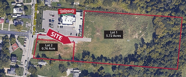

This Property Is For Sale
Current Lease Availabilities
Property Detail
Bridgetown Rd
Cincinnati, OH-KY-IN
ES BRIDGETOWN RD 0.7556 AC S3 T1 FR2
570-0040-0533
HAMILTON
Commercialacreage
Ohio
B and X Area of moderate flood hazard, usually the area between the limits of the 100-year and 500-year floods.
5.72 AC
2025
Forest Park/West
2025
Cincinnati/Dayton
021101
NEARBY LISTINGS FOR SALE OR LEASE
-
-
-
-
No Photo
-
-
-
-
View all Cincinnati listings for sale on LoopNet.com
DEMOGRAPHICS near Bridgetown Rd
1 mile
3 mile
5 mile
2025 Total Population
3,136
32,506
93,950
2030 Population
3,141
32,478
94,344
Pop Growth 2025-2030
+ 0.16%
(0.09%)
+ 0.42%
Average Age
44
42
41
2025 Total Households
1,136
12,277
36,597
HH Growth 2025-2030
+ 0.09%
(0.10%)
+ 0.27%
Median Household Inc
$106,915
$94,490
$85,276
Avg Household Size
2.70
2.60
2.50
2025 Avg HH Vehicles
2.00
2.00
2.00
Median Home Value
$305,346
$299,200
$265,129
Median Year Built
1984
1981
1974
Nearby Places
Map Layers
Map Styles
 Street
 Aerial
Transit
 Traffic
 Biking
Places
Listings with unknown addresses are not visible on the map
- Restaurants
- Banks
- Shops
- Fitness
- Groceries
PUBLIC TRANSPORTATION
AIRPORT
Cincinnati/Northern Kentucky International
Drive
Walk
Distance
Cincinnati/Northern Kentucky International
46 min
27.0 mi
Nearby Properties
Address
Land Use
TOTAL SIZE
Lot Size
Zoning
Address
Land Use
TOTAL SIZE
Lot Size
Zoning
42.35 AC
Address
Land Use
TOTAL SIZE
Lot Size
Zoning
5.38 AC
OO
Address
Land Use
TOTAL SIZE
Lot Size
Zoning
9.52 AC
B
Address
Land Use
TOTAL SIZE
Lot Size
Zoning
12.23 AC
Address
Land Use
TOTAL SIZE
Lot Size
Zoning
474 SF
9.59 AC
A
Address
Land Use
TOTAL SIZE
Lot Size
Zoning
5,640 SF
595 AC
Address
Land Use
TOTAL SIZE
Lot Size
Zoning
1,671 SF
21.48 AC
CCUP
Address
Land Use
TOTAL SIZE
Lot Size
Zoning
Address
Land Use
TOTAL SIZE
Lot Size
Zoning
4.68 AC
E
Address
Land Use
TOTAL SIZE
Lot Size
Zoning
29,084 SF
30.10 AC
DD
Address
Land Use
TOTAL SIZE
Lot Size
Zoning
360 SF
7.79 AC
F
Address
Land Use
TOTAL SIZE
Lot Size
Zoning
18.30 AC
EE
Address
Land Use
TOTAL SIZE
Lot Size
Zoning
8,580 SF
19.31 AC
DD
Address
Land Use
TOTAL SIZE
Lot Size
Zoning
Address
Land Use
TOTAL SIZE
Lot Size
Zoning
87.11 AC
RFC
Address
Land Use
TOTAL SIZE
Lot Size
Zoning
8.69 AC
EE
Address
Land Use
TOTAL SIZE
Lot Size
Zoning
31.99 AC
B
Address
Land Use
TOTAL SIZE
Lot Size
Zoning
58,082 SF
16.25 AC
B
Address
Land Use
TOTAL SIZE
Lot Size
Zoning
2.76 AC
EE
Address
Land Use
TOTAL SIZE
Lot Size
Zoning
Address
Land Use
TOTAL SIZE
Lot Size
Zoning
37,169 SF
12.82 AC
A
Address
Land Use
TOTAL SIZE
Lot Size
Zoning
4,439 SF
1,059.01 AC
AA
Address
Land Use
TOTAL SIZE
Lot Size
Zoning
14.99 AC
Address
Land Use
TOTAL SIZE
Lot Size
Zoning
17.44 AC
AA
Address
Land Use
TOTAL SIZE
Lot Size
Zoning
2,700 SF
5.30 AC
A
Address
Land Use
TOTAL SIZE
Lot Size
Zoning
Address
Land Use
TOTAL SIZE
Lot Size
Zoning
69.35 AC
Address
Land Use
TOTAL SIZE
Lot Size
Zoning
49,284 SF
8.94 AC
A
Address
Land Use
TOTAL SIZE
Lot Size
Zoning
4.59 AC
EE
Address
Land Use
TOTAL SIZE
Lot Size
Zoning
1,208 SF
5.37 AC
EE
The World's #1 Commercial Real Estate Marketplace
Connect with us
© 2026 CoStar Group
The information above has been obtained from sources believed reliable. While we do not doubt its accuracy we have not verified it and make no guarantee, warranty or representation about it. It is your responsibility to independently confirm its accuracy and completeness. Any projections, opinions, assumptions, or estimates used are for example only and do not represent the current or future performance of the property. The value of this transaction to you depends on tax and other factors which should be evaluated by your tax, financial, and legal advisors. You and your advisors should conduct a careful, independent investigation of the property to determine to your satisfaction the suitability of the property for your needs.