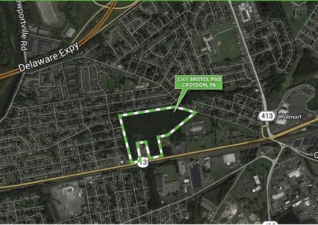
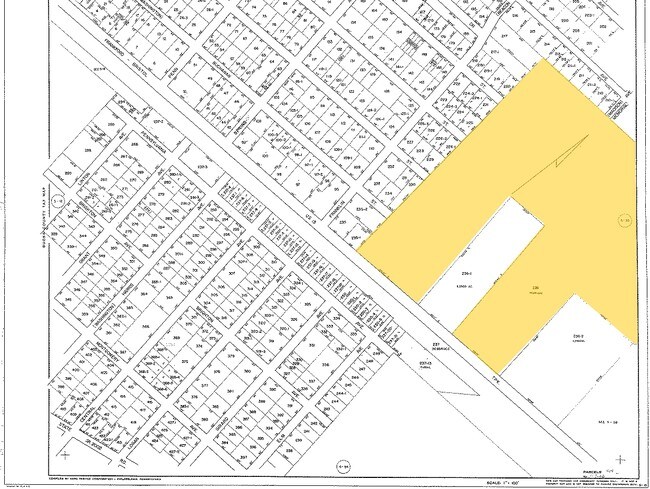
Property Record
Bristol Pike, Croydon, PA 19021

Property Detail
Bristol Pike
05-013-236
49.3943AC NS US 13 212FT E OF FRANKLIN ST 830 ON US13
Commercialnec
BUCKS
M2
Pennsylvania
AE The base floodplain where base flood elevations are provided. AE Zones are now used on new format FIRMs instead of A1-A30 Zones.
49.39 AC
2024
Lower Bucks County
2025
Philadelphia
100302
Philadelphia-Camden-Wilmington, PA-NJ-DE-MD
NEARBY LISTINGS FOR SALE OR LEASE
DEMOGRAPHICS near Bristol Pike
1 mile
3 mile
5 mile
2024 Total Population
10,669
79,839
238,094
2029 Population
10,677
80,487
240,198
Pop Growth 2024-2029
+ 0.07%
+ 0.81%
+ 0.88%
Average Age
42
41
42
2024 Total Households
4,095
30,696
89,822
HH Growth 2024-2029
0.00%
+ 0.79%
+ 0.90%
Median Household Inc
$65,354
$77,787
$85,124
Avg Household Size
2.50
2.50
2.60
2024 Avg HH Vehicles
2.00
2.00
2.00
Median Home Value
$279,493
$307,745
$320,752
Median Year Built
1958
1963
1965
Nearby Places
Map Layers
Map Styles
 Street
 Aerial
Transit
 Traffic
 Biking
Places
Listings with unknown addresses are not visible on the map
- Restaurants
- Banks
- Shops
- Fitness
- Groceries
PUBLIC TRANSPORTATION
COMMUTER RAIL
Croydon (R7 - Southeastern Pennsylvania Transportation Authority Regional Rail (SEPTA Regional Rail))
Drive
Walk
Distance
Croydon (R7 - Southeastern Pennsylvania Transportation Authority Regional Rail (SEPTA Regional Rail))
3 min
1.2 mi
Bristol (R7 - Southeastern Pennsylvania Transportation Authority Regional Rail (SEPTA Regional Rail))
Drive
Walk
Distance
Bristol (R7 - Southeastern Pennsylvania Transportation Authority Regional Rail (SEPTA Regional Rail))
6 min
2.4 mi
AIRPORT
Trenton Mercer
Drive
Walk
Distance
Trenton Mercer
29 min
17.2 mi
Philadelphia International
Drive
Walk
Distance
Philadelphia International
46 min
29.2 mi
Freight Ports
Port of Philadelphia
Drive
Walk
Distance
Port of Philadelphia
26 min
15.5 mi
Nearby Properties
Address
Land Use
TOTAL SIZE
Lot Size
Zoning
Address
Land Use
TOTAL SIZE
Lot Size
Zoning
22,688 SF
32.55 AC
BLI1
Address
Land Use
TOTAL SIZE
Lot Size
Zoning
16.23 AC
R-3
Address
Land Use
TOTAL SIZE
Lot Size
Zoning
253,500 SF
24.28 AC
BLI1
Address
Land Use
TOTAL SIZE
Lot Size
Zoning
11 AC
TRN
Address
Land Use
TOTAL SIZE
Lot Size
Zoning
4,313 SF
1.25 AC
HC-2
Address
Land Use
TOTAL SIZE
Lot Size
Zoning
15.09 AC
I-1
Address
Land Use
TOTAL SIZE
Lot Size
Zoning
29 AC
I-2
Address
Land Use
TOTAL SIZE
Lot Size
Zoning
10.73 AC
BLI1
Address
Land Use
TOTAL SIZE
Lot Size
Zoning
8.60 AC
R-1
Address
Land Use
TOTAL SIZE
Lot Size
Zoning
2.43 AC
W-1
Address
Land Use
TOTAL SIZE
Lot Size
Zoning
242 AC
OS-1
Address
Land Use
TOTAL SIZE
Lot Size
Zoning
9.15 AC
B2
Address
Land Use
TOTAL SIZE
Lot Size
Zoning
19,518 SF
10.81 AC
I-1
Address
Land Use
TOTAL SIZE
Lot Size
Zoning
38,590 SF
1.82 AC
TRN
Address
Land Use
TOTAL SIZE
Lot Size
Zoning
43,445 SF
5.96 AC
Address
Land Use
TOTAL SIZE
Lot Size
Zoning
1.67 AC
TRN
Address
Land Use
TOTAL SIZE
Lot Size
Zoning
Address
Land Use
TOTAL SIZE
Lot Size
Zoning
29,054 SF
12.95 AC
B2
Address
Land Use
TOTAL SIZE
Lot Size
Zoning
3,456 SF
4.88 AC
TRN
Address
Land Use
TOTAL SIZE
Lot Size
Zoning
7,190 SF
5.68 AC
BLI1
Address
Land Use
TOTAL SIZE
Lot Size
Zoning
27,580 SF
2.25 AC
R-2
Address
Land Use
TOTAL SIZE
Lot Size
Zoning
21,642 SF
55.15 AC
I-2
Address
Land Use
TOTAL SIZE
Lot Size
Zoning
11,280 SF
26.16 AC
R3
Address
Land Use
TOTAL SIZE
Lot Size
Zoning
Address
Land Use
TOTAL SIZE
Lot Size
Zoning
66.09 AC
I-2
Address
Land Use
TOTAL SIZE
Lot Size
Zoning
26.40 AC
I-1
Address
Land Use
TOTAL SIZE
Lot Size
Zoning
24,320 SF
3.45 AC
HC-1
Address
Land Use
TOTAL SIZE
Lot Size
Zoning
31,140 SF
5.05 AC
BLI1
Address
Land Use
TOTAL SIZE
Lot Size
Zoning
34,920 SF
38 AC
CD
Address
Land Use
TOTAL SIZE
Lot Size
Zoning
31,497 SF
21.50 AC
1-2
The World's #1 Commercial Real Estate Marketplace
Connect with us
© 2026 CoStar Group
The information above has been obtained from sources believed reliable. While we do not doubt its accuracy we have not verified it and make no guarantee, warranty or representation about it. It is your responsibility to independently confirm its accuracy and completeness. Any projections, opinions, assumptions, or estimates used are for example only and do not represent the current or future performance of the property. The value of this transaction to you depends on tax and other factors which should be evaluated by your tax, financial, and legal advisors. You and your advisors should conduct a careful, independent investigation of the property to determine to your satisfaction the suitability of the property for your needs.