Property Record
Broeker Ln, New Albany, IN 47150
NEARBY LISTINGS FOR SALE OR LEASE
-
-
View all New Albany listings for sale on LoopNet.com
Property Detail
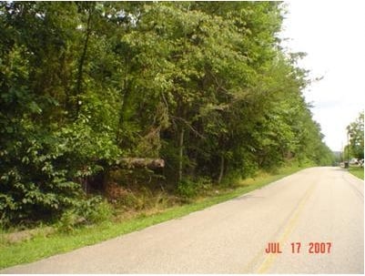
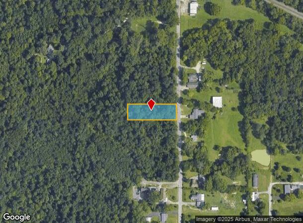
Broeker Ln
Louisville-Jefferson County, KY-IN
Unrecorded Sub
22-05-00-400-247.000-008
SW 1/4 SW 1/4 4-3-6 .63 AC.
Residentialacreage
Floyd
X
Indiana
18019C0275E
0.63 AC
2024
Outlying Floyd County
2024
Louisville
070902
DEMOGRAPHICS near Broeker Ln
1 Mile
3 Mile
5 Mile
2024 Total Population
1,495
37,428
112,272
2029 Population
1,508
37,739
113,813
Pop Growth 2024-2029
+ 0.87%
+ 0.83%
+ 1.37%
Average Age
46
40
39
2024 Total Households
617
15,832
46,032
HH Growth 2024-2029
+ 0.81%
+ 0.80%
+ 1.33%
Median Household Inc
$70,723
$39,481
$41,984
Avg Household Size
2.30
2.30
2.30
2024 Avg HH Vehicles
2.00
1.00
1.00
Median Home Value
$206,488
$125,590
$129,059
Median Year Built
1963
1948
1952
Nearby Places
Map Layers
Map Styles
 Street
 Aerial
- Restaurants
- Banks
- Shops
- Fitness
- Groceries
PUBLIC TRANSPORTATION
AIRPORT
Louisville Muhammad Ali International
DRIVE
WALK
Distance
Louisville Muhammad Ali International
28 min
14.7 mi
SALE & LEASE HISTORY
LISTING DATE
SALE/LEASE

Sep 24, 2016
For Sale
May 23, 2017
For Sale
Mar 22, 2021
For Sale
Nearby Properties
Address
Land Use
TOTAL SIZE
Lot Size
Zoning
Address
Land Use
TOTAL SIZE
Lot Size
Zoning
12,270 SF
13.50 AC
Address
Land Use
TOTAL SIZE
Lot Size
Zoning
143,700 SF
0.29 AC
Address
Land Use
TOTAL SIZE
Lot Size
Zoning
34,308 SF
4.59 AC
Address
Land Use
TOTAL SIZE
Lot Size
Zoning
72,332 SF
2.48 AC
Address
Land Use
TOTAL SIZE
Lot Size
Zoning
83,084 SF
14.65 AC
Address
Land Use
TOTAL SIZE
Lot Size
Zoning
67,600 SF
6.76 AC
EZ1-ENTERP
Address
Land Use
TOTAL SIZE
Lot Size
Zoning
272 SF
210.55 AC
Address
Land Use
TOTAL SIZE
Lot Size
Zoning
35,044 SF
3.39 AC
Address
Land Use
TOTAL SIZE
Lot Size
Zoning
39,851 SF
19.68 AC
Address
Land Use
TOTAL SIZE
Lot Size
Zoning
118,371 SF
11.83 AC
Address
Land Use
TOTAL SIZE
Lot Size
Zoning
75,310 SF
0.83 AC
Address
Land Use
TOTAL SIZE
Lot Size
Zoning
65,748 SF
4.34 AC
Address
Land Use
TOTAL SIZE
Lot Size
Zoning
59,998 SF
7.28 AC
Address
Land Use
TOTAL SIZE
Lot Size
Zoning
26,532 SF
1.20 AC
Address
Land Use
TOTAL SIZE
Lot Size
Zoning
29,354 SF
2.98 AC
R5-RESIDEN
Address
Land Use
TOTAL SIZE
Lot Size
Zoning
75,898 SF
2.16 AC
Address
Land Use
TOTAL SIZE
Lot Size
Zoning
1,758 SF
10.41 AC
Address
Land Use
TOTAL SIZE
Lot Size
Zoning
48,490 SF
0.28 AC
Address
Land Use
TOTAL SIZE
Lot Size
Zoning
43,567 SF
2.12 AC
Address
Land Use
TOTAL SIZE
Lot Size
Zoning
3,330 SF
7.63 AC
EZ1-ENTERP
Address
Land Use
TOTAL SIZE
Lot Size
Zoning
21,780 SF
11.44 AC
Address
Land Use
TOTAL SIZE
Lot Size
Zoning
12,000 SF
4.32 AC
R5A-RESIDE
Address
Land Use
TOTAL SIZE
Lot Size
Zoning
42,039 SF
0.12 AC
Address
Land Use
TOTAL SIZE
Lot Size
Zoning
9,124 SF
2.08 AC
Address
Land Use
TOTAL SIZE
Lot Size
Zoning
26,780 SF
0.72 AC
Address
Land Use
TOTAL SIZE
Lot Size
Zoning
103,078 SF
7.60 AC
Address
Land Use
TOTAL SIZE
Lot Size
Zoning
29,470 SF
3.31 AC
Address
Land Use
TOTAL SIZE
Lot Size
Zoning
61.07 AC
R1-RESIDEN
Address
Land Use
TOTAL SIZE
Lot Size
Zoning
36 SF
41.27 AC
EZ1-ENTERP
Address
Land Use
TOTAL SIZE
Lot Size
Zoning
8.03 AC
R5A-RESIDE
The World's #1 Commercial Real Estate Marketplace
Connect with us
© 2025 CoStar Group
The information above has been obtained from sources believed reliable. While we do not doubt its accuracy we have not verified it and make no guarantee, warranty or representation about it. It is your responsibility to independently confirm its accuracy and completeness. Any projections, opinions, assumptions, or estimates used are for example only and do not represent the current or future performance of the property. The value of this transaction to you depends on tax and other factors which should be evaluated by your tax, financial, and legal advisors. You and your advisors should conduct a careful, independent investigation of the property to determine to your satisfaction the suitability of the property for your needs.