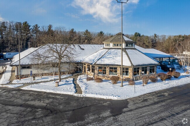
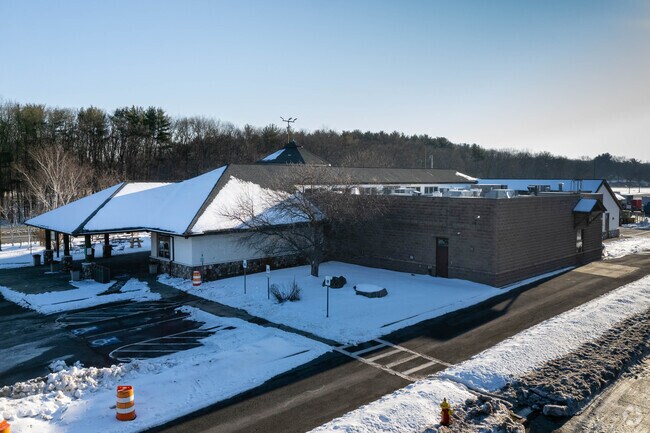
Property Record
Brookview Dr, Schenectady, NY 12303

Property Detail
Brookview Dr
013089-028-000-0005-001-000-0000
THRUWAY SERVICE AREA
Roadsstreetsbridges
ALBANY
F
New York
B and X Area of moderate flood hazard, usually the area between the limits of the 100-year and 500-year floods.
1.000
0
284.30 AC
2025
W Outer Albany County
032901
Albany/Schenectady/Troy
6,889 SF
Albany-Schenectady-Troy, NY
NEARBY LISTINGS FOR SALE OR LEASE
DEMOGRAPHICS near Brookview Dr
1 mile
3 mile
5 mile
2025 Total Population
2,873
38,293
141,533
2030 Population
2,905
38,960
143,605
Pop Growth 2025-2030
+ 1.11%
+ 1.74%
+ 1.46%
Average Age
43
43
41
2025 Total Households
1,066
16,111
56,833
HH Growth 2025-2030
+ 1.22%
+ 1.79%
+ 1.58%
Median Household Inc
$122,196
$93,603
$78,617
Avg Household Size
2.70
2.30
2.40
2025 Avg HH Vehicles
2.00
2.00
2.00
Median Home Value
$376,605
$272,804
$261,090
Median Year Built
1984
1970
1958
Nearby Places
Map Layers
Map Styles
 Street
 Aerial
Layers
 Traffic
 Biking
Places
Listings with unknown addresses are not visible on the map
- Restaurants
- Banks
- Shops
- Fitness
- Groceries
PUBLIC TRANSPORTATION
AIRPORT
Albany International
Drive
Walk
Distance
Albany International
19 min
12.0 mi
Freight Ports
Albany, NY Port
Drive
Walk
Distance
Albany, NY Port
18 min
13.3 mi
Nearby Properties
Address
Land Use
TOTAL SIZE
Lot Size
Zoning
Address
Land Use
TOTAL SIZE
Lot Size
Zoning
11,700 SF
43.80 AC
R2
Address
Land Use
TOTAL SIZE
Lot Size
Zoning
102,862 SF
32.45 AC
CS
Address
Land Use
TOTAL SIZE
Lot Size
Zoning
382,858 SF
70.33 AC
R-1
Address
Land Use
TOTAL SIZE
Lot Size
Zoning
98.20 AC
LC
Address
Land Use
TOTAL SIZE
Lot Size
Zoning
9,000 SF
10.32 AC
GB
Address
Land Use
TOTAL SIZE
Lot Size
Zoning
4,680 SF
11.39 AC
CH
Address
Land Use
TOTAL SIZE
Lot Size
Zoning
19,968 SF
12 AC
MR
Address
Land Use
TOTAL SIZE
Lot Size
Zoning
78,326 SF
27.47 AC
R40
Address
Land Use
TOTAL SIZE
Lot Size
Zoning
45 AC
LC
Address
Land Use
TOTAL SIZE
Lot Size
Zoning
Address
Land Use
TOTAL SIZE
Lot Size
Zoning
86,049 SF
17.10 AC
RO30
Address
Land Use
TOTAL SIZE
Lot Size
Zoning
135,155 SF
6.43 AC
03 - MULTI
Address
Land Use
TOTAL SIZE
Lot Size
Zoning
79,041 SF
13.20 AC
CN
Address
Land Use
TOTAL SIZE
Lot Size
Zoning
120,373 SF
9.68 AC
CS
Address
Land Use
TOTAL SIZE
Lot Size
Zoning
20,630 SF
12.99 AC
MR*
Address
Land Use
TOTAL SIZE
Lot Size
Zoning
97,440 SF
8.15 AC
B-2
Address
Land Use
TOTAL SIZE
Lot Size
Zoning
111,915 SF
15.04 AC
05 - COMME
Address
Land Use
TOTAL SIZE
Lot Size
Zoning
117 AC
06 - INDUS
Address
Land Use
TOTAL SIZE
Lot Size
Zoning
30.20 AC
LC
Address
Land Use
TOTAL SIZE
Lot Size
Zoning
63,762 SF
4 AC
R1
Address
Land Use
TOTAL SIZE
Lot Size
Zoning
68,000 SF
11.20 AC
TH
Address
Land Use
TOTAL SIZE
Lot Size
Zoning
68,080 SF
6.22 AC
CS
Address
Land Use
TOTAL SIZE
Lot Size
Zoning
167,930 SF
9.36 AC
05 - COMME
Address
Land Use
TOTAL SIZE
Lot Size
Zoning
102,028 SF
11.65 AC
CS
Address
Land Use
TOTAL SIZE
Lot Size
Zoning
32,830 SF
17.85 AC
12
Address
Land Use
TOTAL SIZE
Lot Size
Zoning
47,951 SF
8.10 AC
GB
Address
Land Use
TOTAL SIZE
Lot Size
Zoning
71,480 SF
15.40 AC
03 - MULTI
Address
Land Use
TOTAL SIZE
Lot Size
Zoning
51,779 SF
17.50 AC
R-1
Address
Land Use
TOTAL SIZE
Lot Size
Zoning
2.43 AC
R-1
The World's #1 Commercial Real Estate Marketplace
Connect with us
© 2026 CoStar Group
The information above has been obtained from sources believed reliable. While we do not doubt its accuracy we have not verified it and make no guarantee, warranty or representation about it. It is your responsibility to independently confirm its accuracy and completeness. Any projections, opinions, assumptions, or estimates used are for example only and do not represent the current or future performance of the property. The value of this transaction to you depends on tax and other factors which should be evaluated by your tax, financial, and legal advisors. You and your advisors should conduct a careful, independent investigation of the property to determine to your satisfaction the suitability of the property for your needs.