Property Record
2908 Cahaba Trl, Vestavia, AL 35243
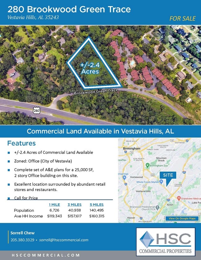
This Property Is For Sale
NEARBY LISTINGS FOR SALE OR LEASE
Property Detail
2908 Cahaba Trl
28-00-22-2-011-012.000
POB 25 FT SE OF INTER OF W/L NW 1/4 SEC 22 TWP 18 R 2W & NE/L U S HWY #280 TH SE 290 FT ALG HWY TH N 525 FT TH SW 32 FT TH S 128 FT TH S 55 FT TH SW 64 FT THS 66 FT TH SW 69 FT TH S 80 FT TO POB SW 1/4 OF NW 1/4
Vacantlandnec
Jefferson
X
Alabama
01117C0080F
0.90 AC
2023
Hwy 280/Jefferson County
2024
Birmingham
0128021011
Birmingham-Hoover, AL
DEMOGRAPHICS near 2908 Cahaba Trl
1 Mile
3 Mile
5 Mile
2024 Total Population
5,718
43,025
155,815
2029 Population
5,573
41,789
153,787
Pop Growth 2024-2029
(2.54%)
(2.87%)
(1.30%)
Average Age
39
39
38
2024 Total Households
2,629
17,189
66,651
HH Growth 2024-2029
(2.81%)
(3.06%)
(1.34%)
Median Household Inc
$85,508
$103,591
$87,883
Avg Household Size
2.20
2.30
2.20
2024 Avg HH Vehicles
2.00
2.00
2.00
Median Home Value
$429,032
$521,988
$417,274
Median Year Built
1985
1981
1977
Nearby Places
- Restaurants
- Banks
- Shops
- Fitness
- Groceries
PUBLIC TRANSPORTATION
COMMUTER RAIL
Birmingham (Crescent - Amtrak)
DRIVE
WALK
Distance
Birmingham (Crescent - Amtrak)
10 min
6.5 mi
AIRPORT
Birmingham-Shuttlesworth International
DRIVE
WALK
Distance
Birmingham-Shuttlesworth International
16 min
10.3 mi
Freight Ports
Port of Mobile
DRIVE
WALK
Distance
Port of Mobile
275 min
252.0 mi
Nearby Properties
Address
Land Use
TOTAL SIZE
Lot Size
Zoning
Address
Land Use
TOTAL SIZE
Lot Size
Zoning
200,418 SF
6.50 AC
C1
Address
Land Use
TOTAL SIZE
Lot Size
Zoning
261,311 SF
20.85 AC
C1
Address
Land Use
TOTAL SIZE
Lot Size
Zoning
212,615 SF
19.66 AC
B-2
Address
Land Use
TOTAL SIZE
Lot Size
Zoning
45,868 SF
6.80 AC
CP Y
Address
Land Use
TOTAL SIZE
Lot Size
Zoning
31,980 SF
99.92 AC
I3/P
Address
Land Use
TOTAL SIZE
Lot Size
Zoning
500,279 SF
52.57 AC
B2
Address
Land Use
TOTAL SIZE
Lot Size
Zoning
154,474 SF
12.50 AC
R-D
Address
Land Use
TOTAL SIZE
Lot Size
Zoning
140,853 SF
27 AC
B-2
Address
Land Use
TOTAL SIZE
Lot Size
Zoning
7,280 SF
35 AC
Address
Land Use
TOTAL SIZE
Lot Size
Zoning
153,413 SF
6.35 AC
C1
Address
Land Use
TOTAL SIZE
Lot Size
Zoning
6 AC
C-1
Address
Land Use
TOTAL SIZE
Lot Size
Zoning
169,501 SF
18 AC
E-2
Address
Land Use
TOTAL SIZE
Lot Size
Zoning
81,807 SF
6.30 AC
C1
Address
Land Use
TOTAL SIZE
Lot Size
Zoning
136,498 SF
11 AC
C1
Address
Land Use
TOTAL SIZE
Lot Size
Zoning
30,967 SF
17.39 AC
Address
Land Use
TOTAL SIZE
Lot Size
Zoning
132,501 SF
50.39 AC
Address
Land Use
TOTAL SIZE
Lot Size
Zoning
235,082 SF
26.10 AC
C1
Address
Land Use
TOTAL SIZE
Lot Size
Zoning
102,373 SF
12.33 AC
R1-E
Address
Land Use
TOTAL SIZE
Lot Size
Zoning
51,699 SF
1.31 AC
PCD-
Address
Land Use
TOTAL SIZE
Lot Size
Zoning
344,434 SF
15.52 AC
R4
Address
Land Use
TOTAL SIZE
Lot Size
Zoning
239,213 SF
17 AC
C1
Address
Land Use
TOTAL SIZE
Lot Size
Zoning
259,316 SF
30 AC
PUD
Address
Land Use
TOTAL SIZE
Lot Size
Zoning
329,064 SF
9 AC
I3
Address
Land Use
TOTAL SIZE
Lot Size
Zoning
321,157 SF
33 AC
C
Address
Land Use
TOTAL SIZE
Lot Size
Zoning
62,543 SF
1.78 AC
R-D
Address
Land Use
TOTAL SIZE
Lot Size
Zoning
59,454 SF
4.21 AC
C1
Address
Land Use
TOTAL SIZE
Lot Size
Zoning
361,937 SF
22 AC
R4
Address
Land Use
TOTAL SIZE
Lot Size
Zoning
125,165 SF
8.07 AC
CP
Address
Land Use
TOTAL SIZE
Lot Size
Zoning
331,413 SF
14.46 AC
R6
Address
Land Use
TOTAL SIZE
Lot Size
Zoning
62,516 SF
1.37 AC
I3
The World's #1 Commercial Real Estate Marketplace
Connect with us
© 2025 CoStar Group
The information above has been obtained from sources believed reliable. While we do not doubt its accuracy we have not verified it and make no guarantee, warranty or representation about it. It is your responsibility to independently confirm its accuracy and completeness. Any projections, opinions, assumptions, or estimates used are for example only and do not represent the current or future performance of the property. The value of this transaction to you depends on tax and other factors which should be evaluated by your tax, financial, and legal advisors. You and your advisors should conduct a careful, independent investigation of the property to determine to your satisfaction the suitability of the property for your needs.