Property Record
Browns Crossroads Rd, Staley, NC 27355
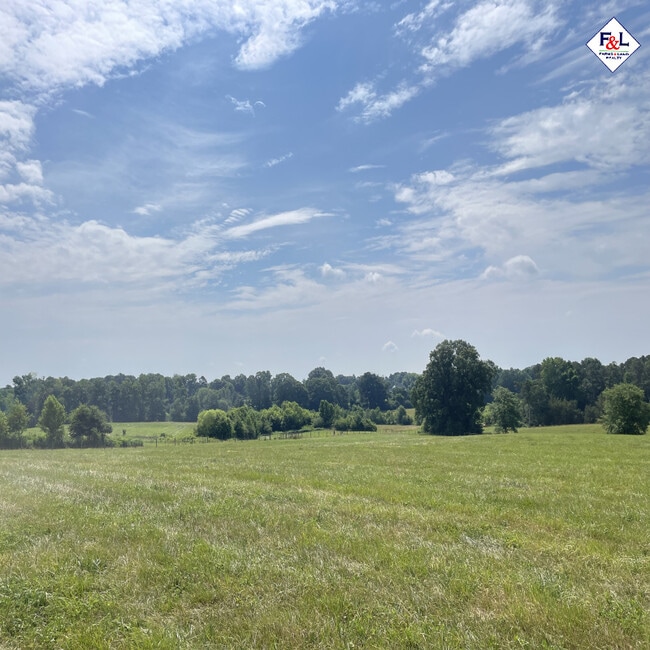

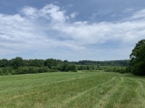
This Property Is For Sale
Property Detail
Browns Crossroads Rd
8723-90-0259
R2469;W R2472 E
Farms
RANDOLPH
RR
North Carolina
AE The base floodplain where base flood elevations are provided. AE Zones are now used on new format FIRMs instead of A1-A30 Zones.
128.90 AC
2025
NE Randolph County
2025
Greensboro/Winston-Salem
031002
Greensboro-High Point, NC
NEARBY LISTINGS FOR SALE OR LEASE
-
-
View all Staley listings for sale on LoopNet.com
DEMOGRAPHICS near Browns Crossroads Rd
1 mile
3 mile
5 mile
2024 Total Population
218
1,999
7,878
2029 Population
220
2,039
8,144
Pop Growth 2024-2029
+ 0.92%
+ 2.00%
+ 3.38%
Average Age
42
42
42
2024 Total Households
87
785
3,085
HH Growth 2024-2029
+ 1.15%
+ 2.04%
+ 3.57%
Median Household Inc
$61,250
$55,377
$56,277
Avg Household Size
2.50
2.50
2.50
2024 Avg HH Vehicles
2.00
2.00
2.00
Median Home Value
$152,777
$175,280
$187,396
Median Year Built
1975
1978
1980
Nearby Places
Map Layers
Map Styles
 Street
 Aerial
Transit
 Traffic
 Biking
Places
Listings with unknown addresses are not visible on the map
- Restaurants
- Banks
- Shops
- Fitness
- Groceries
Nearby Properties
Address
Land Use
TOTAL SIZE
Lot Size
Zoning
Address
Land Use
TOTAL SIZE
Lot Size
Zoning
713.27 AC
SCETJ
Address
Land Use
TOTAL SIZE
Lot Size
Zoning
1,388 SF
75.55 AC
RR
Address
Land Use
TOTAL SIZE
Lot Size
Zoning
9,005 SF
6.66 AC
RA
Address
Land Use
TOTAL SIZE
Lot Size
Zoning
24,715 SF
49.96 AC
LI-CD
Address
Land Use
TOTAL SIZE
Lot Size
Zoning
4,800 SF
97.60 AC
RA
Address
Land Use
TOTAL SIZE
Lot Size
Zoning
80.60 AC
SCETJ
Address
Land Use
TOTAL SIZE
Lot Size
Zoning
9,360 SF
10.03 AC
LI-CD
Address
Land Use
TOTAL SIZE
Lot Size
Zoning
7,730 SF
18.76 AC
RA
Address
Land Use
TOTAL SIZE
Lot Size
Zoning
6,636 SF
2.76 AC
RR
Address
Land Use
TOTAL SIZE
Lot Size
Zoning
6,187 SF
7.05 AC
HC
Address
Land Use
TOTAL SIZE
Lot Size
Zoning
4,000 SF
84.80 AC
R-1
Address
Land Use
TOTAL SIZE
Lot Size
Zoning
121.10 AC
RA
Address
Land Use
TOTAL SIZE
Lot Size
Zoning
85.03 AC
RA
Address
Land Use
TOTAL SIZE
Lot Size
Zoning
37 AC
SCETJ
Address
Land Use
TOTAL SIZE
Lot Size
Zoning
3,693 SF
4.30 AC
RA
Address
Land Use
TOTAL SIZE
Lot Size
Zoning
25.37 AC
SCETJ
Address
Land Use
TOTAL SIZE
Lot Size
Zoning
90.37 AC
RA
Address
Land Use
TOTAL SIZE
Lot Size
Zoning
740 SF
24.09 AC
H-I
Address
Land Use
TOTAL SIZE
Lot Size
Zoning
37 AC
H-I
Address
Land Use
TOTAL SIZE
Lot Size
Zoning
2,472 SF
19.39 AC
HC-CD
Address
Land Use
TOTAL SIZE
Lot Size
Zoning
3,840 SF
1.66 AC
RR
Address
Land Use
TOTAL SIZE
Lot Size
Zoning
21.88 AC
SCETJ
Address
Land Use
TOTAL SIZE
Lot Size
Zoning
59.40 AC
RA
Address
Land Use
TOTAL SIZE
Lot Size
Zoning
62.10 AC
RA
Address
Land Use
TOTAL SIZE
Lot Size
Zoning
5,360 SF
9.80 AC
RA
Address
Land Use
TOTAL SIZE
Lot Size
Zoning
2,880 SF
0.57 AC
HC-CD
Address
Land Use
TOTAL SIZE
Lot Size
Zoning
4,646 SF
0.90 AC
RA
Address
Land Use
TOTAL SIZE
Lot Size
Zoning
2,072 SF
14.05 AC
A-R
Address
Land Use
TOTAL SIZE
Lot Size
Zoning
3.75 AC
HC-CD
Address
Land Use
TOTAL SIZE
Lot Size
Zoning
45.37 AC
RR
The World's #1 Commercial Real Estate Marketplace
Connect with us
© 2026 CoStar Group
The information above has been obtained from sources believed reliable. While we do not doubt its accuracy we have not verified it and make no guarantee, warranty or representation about it. It is your responsibility to independently confirm its accuracy and completeness. Any projections, opinions, assumptions, or estimates used are for example only and do not represent the current or future performance of the property. The value of this transaction to you depends on tax and other factors which should be evaluated by your tax, financial, and legal advisors. You and your advisors should conduct a careful, independent investigation of the property to determine to your satisfaction the suitability of the property for your needs.