Property Record
S S Buckner Rd, Columbia, SC 29203
This Property Is For Sale
NEARBY LISTINGS FOR SALE OR LEASE
Property Detail
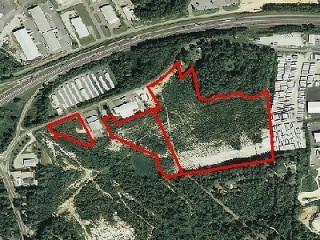
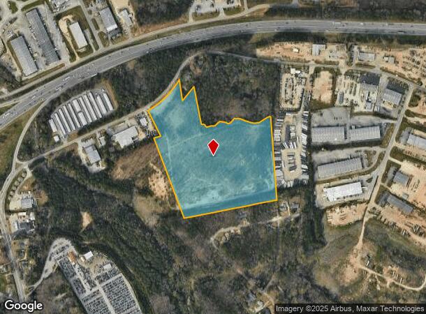
S S Buckner Rd
Columbia, SC
Plat Properties Of Willow Run Properties
09316-03-08
PARCEL 1 #SU #PR X-2274
Agriculturalland
Richland
A
South Carolina
45079C0233L
21.79 AC
2025
North Columbia
2024
Columbia
010701
DEMOGRAPHICS near S S Buckner Rd
1 Mile
3 Mile
5 Mile
2024 Total Population
2,702
40,881
127,454
2029 Population
2,767
41,810
130,335
Pop Growth 2024-2029
+ 2.41%
+ 2.27%
+ 2.26%
Average Age
39
39
38
2024 Total Households
1,227
17,966
54,457
HH Growth 2024-2029
+ 2.44%
+ 2.31%
+ 2.43%
Median Household Inc
$25,519
$35,280
$41,161
Avg Household Size
2.20
2.20
2.10
2024 Avg HH Vehicles
1.00
1.00
1.00
Median Home Value
$86,309
$116,899
$166,253
Median Year Built
1965
1967
1971
Nearby Places
Map Layers
Map Styles
 Street
 Aerial
- Restaurants
- Banks
- Shops
- Fitness
- Groceries
PUBLIC TRANSPORTATION
COMMUTER RAIL
Columbia Amtrak Station (Silver Star - Amtrak)
DRIVE
WALK
Distance
Columbia Amtrak Station (Silver Star - Amtrak)
14 min
5.8 mi
AIRPORT
Columbia Metro
DRIVE
WALK
Distance
Columbia Metro
32 min
15.3 mi
Freight Ports
North Charleston Terminal
DRIVE
WALK
Distance
North Charleston Terminal
132 min
111.6 mi
Nearby Properties
Address
Land Use
TOTAL SIZE
Lot Size
Zoning
Address
Land Use
TOTAL SIZE
Lot Size
Zoning
20,434 SF
17.20 AC
C-1
Address
Land Use
TOTAL SIZE
Lot Size
Zoning
100 SF
156.42 AC
RSF-2
Address
Land Use
TOTAL SIZE
Lot Size
Zoning
278,912 SF
23.24 AC
RM-HD
Address
Land Use
TOTAL SIZE
Lot Size
Zoning
207,112 SF
16.86 AC
RM-HD
Address
Land Use
TOTAL SIZE
Lot Size
Zoning
237,885 SF
20.76 AC
RM-2
Address
Land Use
TOTAL SIZE
Lot Size
Zoning
153,272 SF
9.63 AC
RM-HD
Address
Land Use
TOTAL SIZE
Lot Size
Zoning
2,456 SF
5 AC
C-1
Address
Land Use
TOTAL SIZE
Lot Size
Zoning
96,189 SF
2.22 AC
C-1
Address
Land Use
TOTAL SIZE
Lot Size
Zoning
127,063 SF
14.70 AC
RM-HD
Address
Land Use
TOTAL SIZE
Lot Size
Zoning
34,393 SF
2.96 AC
M-1
Address
Land Use
TOTAL SIZE
Lot Size
Zoning
67,200 SF
1.72 AC
C-1
Address
Land Use
TOTAL SIZE
Lot Size
Zoning
90,430 SF
0.42 AC
C-1
Address
Land Use
TOTAL SIZE
Lot Size
Zoning
23,916 SF
4.43 AC
RG-2
Address
Land Use
TOTAL SIZE
Lot Size
Zoning
124,272 SF
7.06 AC
RM-HD
Address
Land Use
TOTAL SIZE
Lot Size
Zoning
100 SF
44.73 AC
C-1
Address
Land Use
TOTAL SIZE
Lot Size
Zoning
63,842 SF
3.52 AC
C-3
Address
Land Use
TOTAL SIZE
Lot Size
Zoning
4,986 SF
5.74 AC
PUD-C
Address
Land Use
TOTAL SIZE
Lot Size
Zoning
98,436 SF
14 AC
INS-GEN
Address
Land Use
TOTAL SIZE
Lot Size
Zoning
103,405 SF
0.38 AC
C-3
Address
Land Use
TOTAL SIZE
Lot Size
Zoning
82,692 SF
5.87 AC
C-3
Address
Land Use
TOTAL SIZE
Lot Size
Zoning
134,400 SF
5.85 AC
RG-2
Address
Land Use
TOTAL SIZE
Lot Size
Zoning
100 SF
4.44 AC
C-3
Address
Land Use
TOTAL SIZE
Lot Size
Zoning
199,962 SF
40.13 AC
RG-1
Address
Land Use
TOTAL SIZE
Lot Size
Zoning
96,248 SF
5.97 AC
RM-2
Address
Land Use
TOTAL SIZE
Lot Size
Zoning
8,032 SF
3.20 AC
C-1
Address
Land Use
TOTAL SIZE
Lot Size
Zoning
32,030 SF
1.06 AC
M-1
Address
Land Use
TOTAL SIZE
Lot Size
Zoning
194,212 SF
15.10 AC
RG-2
Address
Land Use
TOTAL SIZE
Lot Size
Zoning
107,302 SF
16.77 AC
EC
Address
Land Use
TOTAL SIZE
Lot Size
Zoning
16,378 SF
1.97 AC
RSF-3
Address
Land Use
TOTAL SIZE
Lot Size
Zoning
67,800 SF
1.54 AC
C-1
The World's #1 Commercial Real Estate Marketplace
Connect with us
© 2026 CoStar Group
The information above has been obtained from sources believed reliable. While we do not doubt its accuracy we have not verified it and make no guarantee, warranty or representation about it. It is your responsibility to independently confirm its accuracy and completeness. Any projections, opinions, assumptions, or estimates used are for example only and do not represent the current or future performance of the property. The value of this transaction to you depends on tax and other factors which should be evaluated by your tax, financial, and legal advisors. You and your advisors should conduct a careful, independent investigation of the property to determine to your satisfaction the suitability of the property for your needs.