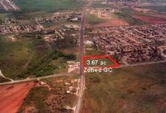
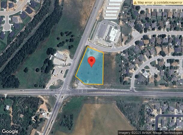
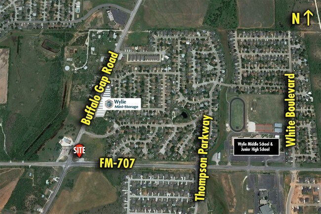
Property Record
8049 Buffalo Gap Rd, Abilene, TX 79606
NEARBY LISTINGS FOR SALE OR LEASE
Property Detail
8049 Buffalo Gap Rd
Abilene, TX
Mesquite Forest Estates Sec 2
41541
MESQUITE FOREST ESTATES SEC 2, BLOCK B, LOT 1
Commercialacreage
Taylor
X
Texas
48441C0331F
1
2024
2.11 AC
2025
Far Southside
013402
Other Market Areas
DEMOGRAPHICS near 8049 Buffalo Gap Rd
1 Mile
3 Mile
5 Mile
2024 Total Population
4,024
17,833
47,808
2029 Population
4,150
18,503
49,280
Pop Growth 2024-2029
+ 3.13%
+ 3.76%
+ 3.08%
Average Age
34
39
37
2024 Total Households
1,405
6,631
18,731
HH Growth 2024-2029
+ 3.35%
+ 3.97%
+ 3.28%
Median Household Inc
$67,418
$81,366
$64,843
Avg Household Size
2.80
2.60
2.50
2024 Avg HH Vehicles
2.00
2.00
2.00
Median Home Value
$209,470
$237,241
$214,110
Median Year Built
1998
1996
1988
Nearby Places
Map Layers
Map Styles
 Street
 Aerial
- Restaurants
- Banks
- Shops
- Fitness
- Groceries
PUBLIC TRANSPORTATION
AIRPORT
Abilene Regional
DRIVE
WALK
Distance
Abilene Regional
19 min
11.8 mi
SALE & LEASE HISTORY
LISTING DATE
SALE/LEASE

Feb 10, 2017
For Sale
Aug 01, 2017
For Sale
Nearby Properties
Address
Land Use
TOTAL SIZE
Lot Size
Zoning
Address
Land Use
TOTAL SIZE
Lot Size
Zoning
234,028 SF
65.80 AC
Address
Land Use
TOTAL SIZE
Lot Size
Zoning
245,071 SF
25.92 AC
Address
Land Use
TOTAL SIZE
Lot Size
Zoning
320,276 SF
50.74 AC
Address
Land Use
TOTAL SIZE
Lot Size
Zoning
76,727 SF
4.50 AC
Address
Land Use
TOTAL SIZE
Lot Size
Zoning
167,314 SF
11.01 AC
Address
Land Use
TOTAL SIZE
Lot Size
Zoning
152,468 SF
18.04 AC
Address
Land Use
TOTAL SIZE
Lot Size
Zoning
97,467 SF
27.73 AC
Address
Land Use
TOTAL SIZE
Lot Size
Zoning
159,335 SF
15.04 AC
Address
Land Use
TOTAL SIZE
Lot Size
Zoning
6.55 AC
Address
Land Use
TOTAL SIZE
Lot Size
Zoning
41,808 SF
3.76 AC
Address
Land Use
TOTAL SIZE
Lot Size
Zoning
71,892 SF
3.75 AC
Address
Land Use
TOTAL SIZE
Lot Size
Zoning
82,182 SF
7.59 AC
Address
Land Use
TOTAL SIZE
Lot Size
Zoning
84,658 SF
9.60 AC
Address
Land Use
TOTAL SIZE
Lot Size
Zoning
82,614 SF
7.48 AC
Address
Land Use
TOTAL SIZE
Lot Size
Zoning
34,956 SF
7.06 AC
Address
Land Use
TOTAL SIZE
Lot Size
Zoning
66,190 SF
6.07 AC
Address
Land Use
TOTAL SIZE
Lot Size
Zoning
27,712 SF
8.57 AC
Address
Land Use
TOTAL SIZE
Lot Size
Zoning
54,446 SF
12.59 AC
Address
Land Use
TOTAL SIZE
Lot Size
Zoning
110,807 SF
81.04 AC
Address
Land Use
TOTAL SIZE
Lot Size
Zoning
80,535 SF
2.82 AC
Address
Land Use
TOTAL SIZE
Lot Size
Zoning
29,064 SF
2.75 AC
Address
Land Use
TOTAL SIZE
Lot Size
Zoning
23,460 SF
14.35 AC
Address
Land Use
TOTAL SIZE
Lot Size
Zoning
51,347 SF
2.59 AC
Address
Land Use
TOTAL SIZE
Lot Size
Zoning
130,130 SF
7.66 AC
Address
Land Use
TOTAL SIZE
Lot Size
Zoning
32,350 SF
15.11 AC
Address
Land Use
TOTAL SIZE
Lot Size
Zoning
26,174 SF
3.18 AC
Address
Land Use
TOTAL SIZE
Lot Size
Zoning
85,671 SF
21.25 AC
Address
Land Use
TOTAL SIZE
Lot Size
Zoning
29,400 SF
5.63 AC
Address
Land Use
TOTAL SIZE
Lot Size
Zoning
40,960 SF
8.73 AC
Address
Land Use
TOTAL SIZE
Lot Size
Zoning
10,841 SF
2.17 AC
The World's #1 Commercial Real Estate Marketplace
Connect with us
© 2026 CoStar Group
The information above has been obtained from sources believed reliable. While we do not doubt its accuracy we have not verified it and make no guarantee, warranty or representation about it. It is your responsibility to independently confirm its accuracy and completeness. Any projections, opinions, assumptions, or estimates used are for example only and do not represent the current or future performance of the property. The value of this transaction to you depends on tax and other factors which should be evaluated by your tax, financial, and legal advisors. You and your advisors should conduct a careful, independent investigation of the property to determine to your satisfaction the suitability of the property for your needs.