Property Record
Buffington Rd, South Fulton, GA 30349


This Property Is For Sale
NEARBY LISTINGS FOR SALE OR LEASE
Property Detail
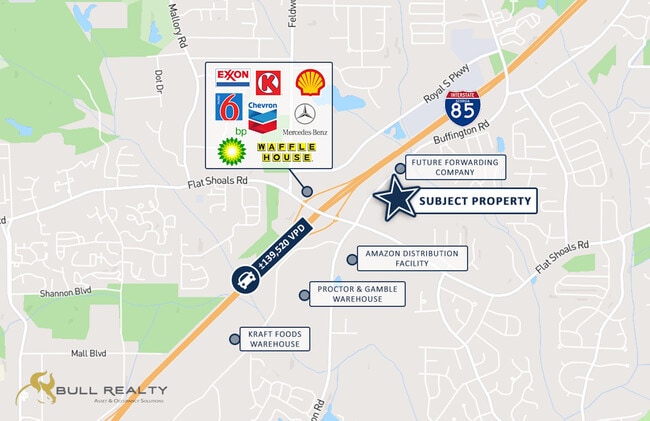
Buffington Rd
Atlanta-Sandy Springs-Roswell, GA
AN VACANT 4/03 AN LOT VACANT;BORDERS I-85 2/04
09F-2411-0082-008-8
Fulton
Residentialacreage
Georgia
X
82
13121C0459F
3 AC
2024
North Clayton/Airport
2025
Atlanta
010529
DEMOGRAPHICS near Buffington Rd
1 Mile
3 Mile
5 Mile
2024 Total Population
5,364
58,358
142,951
2029 Population
5,526
60,466
147,233
Pop Growth 2024-2029
+ 3.02%
+ 3.61%
+ 3.00%
Average Age
38
37
37
2024 Total Households
1,921
21,531
53,731
HH Growth 2024-2029
+ 3.18%
+ 3.74%
+ 3.02%
Median Household Inc
$74,166
$58,629
$55,003
Avg Household Size
2.70
2.60
2.60
2024 Avg HH Vehicles
2.00
2.00
2.00
Median Home Value
$153,248
$167,081
$183,131
Median Year Built
1998
1993
1991
Nearby Places
Map Layers
Map Styles
 Street
 Aerial
- Restaurants
- Banks
- Shops
- Fitness
- Groceries
PUBLIC TRANSPORTATION
AIRPORT
Hartsfield - Jackson Atlanta International
DRIVE
WALK
Distance
Hartsfield - Jackson Atlanta International
16 min
10.0 mi
Freight Ports
Georgia Ports - Savannah
DRIVE
WALK
Distance
Georgia Ports - Savannah
278 min
247.2 mi
Nearby Properties
Address
Land Use
TOTAL SIZE
Lot Size
Zoning
Address
Land Use
TOTAL SIZE
Lot Size
Zoning
929,571 SF
65.66 AC
M1
Address
Land Use
TOTAL SIZE
Lot Size
Zoning
2,329,350 SF
32.55 AC
A
Address
Land Use
TOTAL SIZE
Lot Size
Zoning
992,870 SF
59.71 AC
M1
Address
Land Use
TOTAL SIZE
Lot Size
Zoning
1,020,000 SF
59.94 AC
Address
Land Use
TOTAL SIZE
Lot Size
Zoning
1,026,040 SF
72.52 AC
M1
Address
Land Use
TOTAL SIZE
Lot Size
Zoning
948,900 SF
16.24 AC
RM
Address
Land Use
TOTAL SIZE
Lot Size
Zoning
4,381,104 SF
26.70 AC
AG1
Address
Land Use
TOTAL SIZE
Lot Size
Zoning
744,000 SF
60.69 AC
GC
Address
Land Use
TOTAL SIZE
Lot Size
Zoning
997,011 SF
68.07 AC
M1
Address
Land Use
TOTAL SIZE
Lot Size
Zoning
85,347 SF
49.56 AC
AG1
Address
Land Use
TOTAL SIZE
Lot Size
Zoning
3,904,656 SF
30.58 AC
RM
Address
Land Use
TOTAL SIZE
Lot Size
Zoning
768,288 SF
40.65 AC
M1
Address
Land Use
TOTAL SIZE
Lot Size
Zoning
606,450 SF
34.63 AC
M1
Address
Land Use
TOTAL SIZE
Lot Size
Zoning
358,011 SF
60.44 AC
AG1
Address
Land Use
TOTAL SIZE
Lot Size
Zoning
247,088 SF
20.90 AC
Address
Land Use
TOTAL SIZE
Lot Size
Zoning
773,776 SF
61.42 AC
M1
Address
Land Use
TOTAL SIZE
Lot Size
Zoning
499,800 SF
18.43 AC
AG1
Address
Land Use
TOTAL SIZE
Lot Size
Zoning
567,000 SF
41.83 AC
AG1
Address
Land Use
TOTAL SIZE
Lot Size
Zoning
1,053,234 SF
14.47 AC
RM
Address
Land Use
TOTAL SIZE
Lot Size
Zoning
234,763 SF
22.43 AC
OI
Address
Land Use
TOTAL SIZE
Lot Size
Zoning
7.18 AC
R3
Address
Land Use
TOTAL SIZE
Lot Size
Zoning
1,466,922 SF
21.58 AC
C1
Address
Land Use
TOTAL SIZE
Lot Size
Zoning
281,032 SF
18.03 AC
M1
Address
Land Use
TOTAL SIZE
Lot Size
Zoning
2,404,061 SF
20.21 AC
RM
Address
Land Use
TOTAL SIZE
Lot Size
Zoning
32.52 AC
C2
Address
Land Use
TOTAL SIZE
Lot Size
Zoning
64,075 SF
2.88 AC
RM
Address
Land Use
TOTAL SIZE
Lot Size
Zoning
508,696 SF
94.30 AC
M1C
Address
Land Use
TOTAL SIZE
Lot Size
Zoning
312,240 SF
38.93 AC
MIA
Address
Land Use
TOTAL SIZE
Lot Size
Zoning
146,522 SF
22.04 AC
AG1
Address
Land Use
TOTAL SIZE
Lot Size
Zoning
230,068 SF
22.64 AC
M1
The World's #1 Commercial Real Estate Marketplace
Connect with us
© 2025 CoStar Group
The information above has been obtained from sources believed reliable. While we do not doubt its accuracy we have not verified it and make no guarantee, warranty or representation about it. It is your responsibility to independently confirm its accuracy and completeness. Any projections, opinions, assumptions, or estimates used are for example only and do not represent the current or future performance of the property. The value of this transaction to you depends on tax and other factors which should be evaluated by your tax, financial, and legal advisors. You and your advisors should conduct a careful, independent investigation of the property to determine to your satisfaction the suitability of the property for your needs.