Property Record
Bulverde Rd, San Antonio, TX 78259
NEARBY LISTINGS FOR SALE OR LEASE
Property Detail
Bulverde Rd
San Antonio-New Braunfels, TX
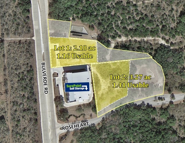
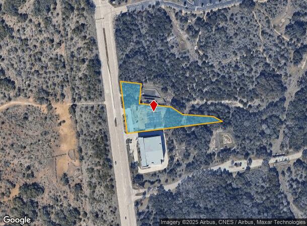
Bulverde Rd Rosehart Newcity 1
17728-012-0030
NCB 17728 BLK 12 LOT 3 (BULVERDE RD AT ROSEHEART) 2016- NEW ACCT PER PLAT 9691/25-28 FILED 10-23-15
Daycare
Bexar
X
Texas
48029C0260G
3
2024
2.18 AC
2025
Far North Central
121903
San Antonio
12,671 SF
DEMOGRAPHICS near Bulverde Rd
1 Mile
3 Mile
5 Mile
2024 Total Population
4,916
69,805
199,174
2029 Population
5,220
74,474
211,919
Pop Growth 2024-2029
+ 6.18%
+ 6.69%
+ 6.40%
Average Age
39
38
38
2024 Total Households
1,969
26,103
75,129
HH Growth 2024-2029
+ 6.25%
+ 6.87%
+ 6.61%
Median Household Inc
$90,871
$92,068
$86,173
Avg Household Size
2.50
2.60
2.60
2024 Avg HH Vehicles
2.00
2.00
2.00
Median Home Value
$317,994
$289,396
$277,962
Median Year Built
2009
2001
1998
Nearby Places
Map Layers
Map Styles
 Street
 Aerial
- Restaurants
- Banks
- Shops
- Fitness
- Groceries
PUBLIC TRANSPORTATION
AIRPORT
San Antonio International
DRIVE
WALK
Distance
San Antonio International
17 min
11.3 mi
Freight Ports
Calhoun Port
DRIVE
WALK
Distance
Calhoun Port
185 min
153.9 mi
SALE & LEASE HISTORY
LISTING DATE
SALE/LEASE

Sep 24, 2016
For Sale
Oct 30, 2018
For Sale
Mar 27, 2017
For Sale
Nearby Properties
Address
Land Use
TOTAL SIZE
Lot Size
Zoning
Address
Land Use
TOTAL SIZE
Lot Size
Zoning
621,591 SF
15.25 AC
Address
Land Use
TOTAL SIZE
Lot Size
Zoning
390,736 SF
31.72 AC
Address
Land Use
TOTAL SIZE
Lot Size
Zoning
435,882 SF
27.85 AC
Address
Land Use
TOTAL SIZE
Lot Size
Zoning
5,687 SF
19.39 AC
Address
Land Use
TOTAL SIZE
Lot Size
Zoning
391,871 SF
17.94 AC
Address
Land Use
TOTAL SIZE
Lot Size
Zoning
37,195 SF
1,118.06 AC
Address
Land Use
TOTAL SIZE
Lot Size
Zoning
311,728 SF
7.47 AC
Address
Land Use
TOTAL SIZE
Lot Size
Zoning
325,041 SF
25.31 AC
Address
Land Use
TOTAL SIZE
Lot Size
Zoning
115.46 AC
Address
Land Use
TOTAL SIZE
Lot Size
Zoning
371,475 SF
20 AC
Address
Land Use
TOTAL SIZE
Lot Size
Zoning
383,541 SF
12.41 AC
Address
Land Use
TOTAL SIZE
Lot Size
Zoning
298,710 SF
11.36 AC
Address
Land Use
TOTAL SIZE
Lot Size
Zoning
307,210 SF
14.26 AC
Address
Land Use
TOTAL SIZE
Lot Size
Zoning
225,819 SF
23.29 AC
Address
Land Use
TOTAL SIZE
Lot Size
Zoning
280,330 SF
20.99 AC
Address
Land Use
TOTAL SIZE
Lot Size
Zoning
441,676 SF
19.99 AC
Address
Land Use
TOTAL SIZE
Lot Size
Zoning
306,523 SF
16.29 AC
Address
Land Use
TOTAL SIZE
Lot Size
Zoning
290,188 SF
14.60 AC
Address
Land Use
TOTAL SIZE
Lot Size
Zoning
341,841 SF
22 AC
Address
Land Use
TOTAL SIZE
Lot Size
Zoning
249,562 SF
9.65 AC
Address
Land Use
TOTAL SIZE
Lot Size
Zoning
340,570 SF
19.15 AC
Address
Land Use
TOTAL SIZE
Lot Size
Zoning
408,619 SF
71.19 AC
Address
Land Use
TOTAL SIZE
Lot Size
Zoning
907.40 AC
Address
Land Use
TOTAL SIZE
Lot Size
Zoning
240,644 SF
16.35 AC
Address
Land Use
TOTAL SIZE
Lot Size
Zoning
281,805 SF
14.52 AC
Address
Land Use
TOTAL SIZE
Lot Size
Zoning
297,882 SF
17.16 AC
Address
Land Use
TOTAL SIZE
Lot Size
Zoning
256,048 SF
15.45 AC
Address
Land Use
TOTAL SIZE
Lot Size
Zoning
258,951 SF
15.43 AC
Address
Land Use
TOTAL SIZE
Lot Size
Zoning
146,700 SF
56.18 AC
Address
Land Use
TOTAL SIZE
Lot Size
Zoning
256,497 SF
16.53 AC
The World's #1 Commercial Real Estate Marketplace
Connect with us
© 2025 CoStar Group
The information above has been obtained from sources believed reliable. While we do not doubt its accuracy we have not verified it and make no guarantee, warranty or representation about it. It is your responsibility to independently confirm its accuracy and completeness. Any projections, opinions, assumptions, or estimates used are for example only and do not represent the current or future performance of the property. The value of this transaction to you depends on tax and other factors which should be evaluated by your tax, financial, and legal advisors. You and your advisors should conduct a careful, independent investigation of the property to determine to your satisfaction the suitability of the property for your needs.