Property Record
Burdon Rd, Chesterfield Township, MI 48047
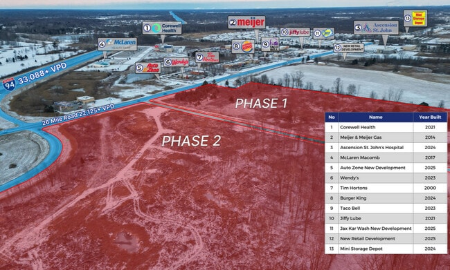
NEARBY LISTINGS FOR SALE OR LEASE
Property Detail
Burdon Rd
15-09-01-100-007
T3N,R14E SEC 1 E 13 ACRES OF S 1/2 OF NE 1/4 OF NW 1/4 SEC 1; EXC COMM AT N 1/4 POST SEC 1 ; TH S0*45'45"E 1011.48 FT TO PT
Commercialacreage
Macomb
X
Michigan
26099C0259G
15.40 AC
2024
Macomb East
2025
Detroit
221200
Detroit-Warren-Dearborn, MI
DEMOGRAPHICS near Burdon Rd
1 Mile
3 Mile
5 Mile
2024 Total Population
1,743
28,514
59,259
2029 Population
1,788
28,655
59,490
Pop Growth 2024-2029
+ 2.58%
+ 0.49%
+ 0.39%
Average Age
43
39
40
2024 Total Households
416
9,603
22,234
HH Growth 2024-2029
+ 4.33%
+ 0.49%
+ 0.47%
Median Household Inc
$56,141
$82,820
$77,801
Avg Household Size
2.70
2.80
2.50
2024 Avg HH Vehicles
2.00
2.00
2.00
Median Home Value
$132,894
$243,154
$249,728
Median Year Built
2007
1999
1994
Nearby Places
Map Layers
Map Styles
 Street
 Aerial
- Restaurants
- Banks
- Shops
- Fitness
- Groceries
Nearby Properties
Address
Land Use
TOTAL SIZE
Lot Size
Zoning
Address
Land Use
TOTAL SIZE
Lot Size
Zoning
115,695 SF
Address
Land Use
TOTAL SIZE
Lot Size
Zoning
147,578 SF
12.84 AC
GC
Address
Land Use
TOTAL SIZE
Lot Size
Zoning
316,907 SF
21.18 AC
M2 GEN
Address
Land Use
TOTAL SIZE
Lot Size
Zoning
210,688 SF
20.13 AC
CG
Address
Land Use
TOTAL SIZE
Lot Size
Zoning
169,535 SF
12.20 AC
I
Address
Land Use
TOTAL SIZE
Lot Size
Zoning
7,262 SF
127.87 AC
MH
Address
Land Use
TOTAL SIZE
Lot Size
Zoning
276,497 SF
31.19 AC
I-1
Address
Land Use
TOTAL SIZE
Lot Size
Zoning
89,620 SF
17.89 AC
Address
Land Use
TOTAL SIZE
Lot Size
Zoning
60,123 SF
120 AC
I-2
Address
Land Use
TOTAL SIZE
Lot Size
Zoning
74,952 SF
6.05 AC
RM-2
Address
Land Use
TOTAL SIZE
Lot Size
Zoning
3,799 SF
56.46 AC
MH
Address
Land Use
TOTAL SIZE
Lot Size
Zoning
176,142 SF
21.95 AC
IND
Address
Land Use
TOTAL SIZE
Lot Size
Zoning
26,578 SF
31.52 AC
IR
Address
Land Use
TOTAL SIZE
Lot Size
Zoning
49,600 SF
14.50 AC
I-2
Address
Land Use
TOTAL SIZE
Lot Size
Zoning
88,116 SF
5.66 AC
IO
Address
Land Use
TOTAL SIZE
Lot Size
Zoning
30,878 SF
5.32 AC
IO
Address
Land Use
TOTAL SIZE
Lot Size
Zoning
22,140 SF
I
Address
Land Use
TOTAL SIZE
Lot Size
Zoning
55,821 SF
M2 GEN
Address
Land Use
TOTAL SIZE
Lot Size
Zoning
30,240 SF
3.03 AC
GC
Address
Land Use
TOTAL SIZE
Lot Size
Zoning
15,788 SF
4.28 AC
CG
Address
Land Use
TOTAL SIZE
Lot Size
Zoning
8.66 AC
GC
Address
Land Use
TOTAL SIZE
Lot Size
Zoning
58,392 SF
3.66 AC
M1 LIG
Address
Land Use
TOTAL SIZE
Lot Size
Zoning
19,280 SF
3.97 AC
M2 GEN
Address
Land Use
TOTAL SIZE
Lot Size
Zoning
53,540 SF
7.99 AC
I
Address
Land Use
TOTAL SIZE
Lot Size
Zoning
85,097 SF
4.87 AC
M2 GEN
Address
Land Use
TOTAL SIZE
Lot Size
Zoning
21,944 SF
131.37 AC
CG
Address
Land Use
TOTAL SIZE
Lot Size
Zoning
18,905 SF
6.40 AC
RO
Address
Land Use
TOTAL SIZE
Lot Size
Zoning
3,418 SF
60 AC
CG
Address
Land Use
TOTAL SIZE
Lot Size
Zoning
3,927 SF
85.22 AC
MF
Address
Land Use
TOTAL SIZE
Lot Size
Zoning
22.50 AC
The World's #1 Commercial Real Estate Marketplace
Connect with us
© 2025 CoStar Group
The information above has been obtained from sources believed reliable. While we do not doubt its accuracy we have not verified it and make no guarantee, warranty or representation about it. It is your responsibility to independently confirm its accuracy and completeness. Any projections, opinions, assumptions, or estimates used are for example only and do not represent the current or future performance of the property. The value of this transaction to you depends on tax and other factors which should be evaluated by your tax, financial, and legal advisors. You and your advisors should conduct a careful, independent investigation of the property to determine to your satisfaction the suitability of the property for your needs.