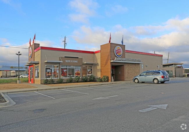
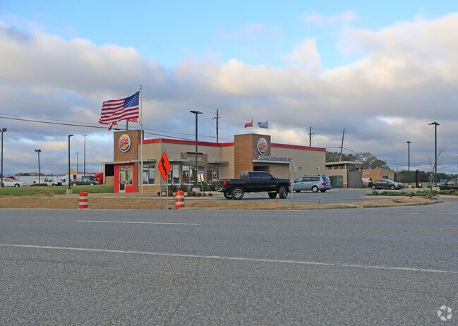
Property Record
5076 Highway 31, Calera, AL 35040

Save to a Folder
{{folder.Name}}
{{folder.ListingIds.length}} Properties
{{folder.ListingIds.length}} Property
Create a New Folder
Property Detail
5076 Highway 31
Birmingham, AL
LESS: ROW PROJECT STPBH-I065(404)
28-2-04-0-001-012-017
SHELBY
Restaurantdrivein
Alabama
B and X Area of moderate flood hazard, usually the area between the limits of the 100-year and 500-year floods.
6c
2025
0.72 AC
2025
I-65 Corr/S Shelby County
030502
Birmingham
3,104 SF
NEARBY LISTINGS FOR SALE OR LEASE
DEMOGRAPHICS near 5076 Highway 31
1 mile
3 mile
5 mile
2025 Total Population
852
14,117
27,897
2030 Population
902
14,769
29,273
Pop Growth 2025-2030
+ 5.87%
+ 4.62%
+ 4.93%
Average Age
39
37
38
2025 Total Households
307
5,330
10,391
HH Growth 2025-2030
+ 5.86%
+ 4.56%
+ 4.93%
Median Household Inc
$81,111
$76,828
$79,569
Avg Household Size
2.70
2.60
2.60
2025 Avg HH Vehicles
2.00
2.00
2.00
Median Home Value
$274,691
$232,199
$248,604
Median Year Built
1995
2004
2003
Nearby Places
Map Layers
Map Styles
 Street
 Aerial
Layers
 Traffic
 Biking
Places
Listings with unknown addresses are not visible on the map
- Restaurants
- Banks
- Shops
- Fitness
- Groceries
PUBLIC TRANSPORTATION
AIRPORT
Birmingham-Shuttlesworth International
Drive
Walk
Distance
Birmingham-Shuttlesworth International
44 min
34.9 mi
Nearby Properties
Address
Land Use
TOTAL SIZE
Lot Size
Zoning
Address
Land Use
TOTAL SIZE
Lot Size
Zoning
1,456 SF
20.58 AC
Address
Land Use
TOTAL SIZE
Lot Size
Zoning
573,600 SF
19.96 AC
Address
Land Use
TOTAL SIZE
Lot Size
Zoning
110,860 SF
16.90 AC
Address
Land Use
TOTAL SIZE
Lot Size
Zoning
500,500 SF
17.45 AC
Address
Land Use
TOTAL SIZE
Lot Size
Zoning
14,160 SF
6.75 AC
Address
Land Use
TOTAL SIZE
Lot Size
Zoning
249,500 SF
16.15 AC
Address
Land Use
TOTAL SIZE
Lot Size
Zoning
139,905 SF
34.78 AC
Address
Land Use
TOTAL SIZE
Lot Size
Zoning
384,266 SF
20.66 AC
Address
Land Use
TOTAL SIZE
Lot Size
Zoning
6,234 SF
33 AC
Address
Land Use
TOTAL SIZE
Lot Size
Zoning
3,941 SF
5.60 AC
Address
Land Use
TOTAL SIZE
Lot Size
Zoning
270,600 SF
21.75 AC
Address
Land Use
TOTAL SIZE
Lot Size
Zoning
46,031 SF
11.09 AC
Address
Land Use
TOTAL SIZE
Lot Size
Zoning
208,000 SF
11.91 AC
Address
Land Use
TOTAL SIZE
Lot Size
Zoning
116,219 SF
35.20 AC
Address
Land Use
TOTAL SIZE
Lot Size
Zoning
97,384 SF
2.94 AC
Address
Land Use
TOTAL SIZE
Lot Size
Zoning
104,643 SF
5.39 AC
Address
Land Use
TOTAL SIZE
Lot Size
Zoning
53,022 SF
2.20 AC
Address
Land Use
TOTAL SIZE
Lot Size
Zoning
8,328 SF
6.89 AC
Address
Land Use
TOTAL SIZE
Lot Size
Zoning
241.36 AC
Address
Land Use
TOTAL SIZE
Lot Size
Zoning
73,825 SF
15 AC
Address
Land Use
TOTAL SIZE
Lot Size
Zoning
14,163 SF
12.78 AC
Address
Land Use
TOTAL SIZE
Lot Size
Zoning
6,275 SF
290 AC
Address
Land Use
TOTAL SIZE
Lot Size
Zoning
600 SF
69 AC
Address
Land Use
TOTAL SIZE
Lot Size
Zoning
180.22 AC
Address
Land Use
TOTAL SIZE
Lot Size
Zoning
38,429 SF
4.28 AC
Address
Land Use
TOTAL SIZE
Lot Size
Zoning
60,000 SF
10.06 AC
Address
Land Use
TOTAL SIZE
Lot Size
Zoning
38,816 SF
33.96 AC
Address
Land Use
TOTAL SIZE
Lot Size
Zoning
36,430 SF
4.10 AC
Address
Land Use
TOTAL SIZE
Lot Size
Zoning
66,260 SF
3.84 AC
Address
Land Use
TOTAL SIZE
Lot Size
Zoning
14,700 SF
12 AC
The World's #1 Commercial Real Estate Marketplace
Connect with us
© 2026 CoStar Group
The information above has been obtained from sources believed reliable. While we do not doubt its accuracy we have not verified it and make no guarantee, warranty or representation about it. It is your responsibility to independently confirm its accuracy and completeness. Any projections, opinions, assumptions, or estimates used are for example only and do not represent the current or future performance of the property. The value of this transaction to you depends on tax and other factors which should be evaluated by your tax, financial, and legal advisors. You and your advisors should conduct a careful, independent investigation of the property to determine to your satisfaction the suitability of the property for your needs.