Property Record
1615 Burns Ave, Lake Wales, FL 33898


This Property Is For Sale
NEARBY LISTINGS FOR SALE OR LEASE
Property Detail
1615 Burns Ave
Lakeland-Winter Haven, FL
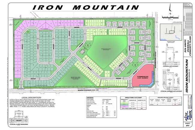
Mountain Lake Unrecorded Plat
27-29-22-866300-041010
MOUNTAIN LAKE UNRECORDED PLAT SEC 31 29 28 BLK 41 LOTS A TO H LESS MAINT R/W & LESS R/W AS RECORDED IN OR 4884-1111
Residentialacreage
Polk
AE
Florida
12105C0570G
a-h
2024
76.28 AC
2025
Polk County
014303
Tampa/St Petersburg
DEMOGRAPHICS near 1615 Burns Ave
1 Mile
3 Mile
5 Mile
2024 Total Population
3,112
20,984
30,735
2029 Population
3,592
24,559
36,117
Pop Growth 2024-2029
+ 15.42%
+ 17.04%
+ 17.51%
Average Age
40
40
41
2024 Total Households
1,190
8,121
12,032
HH Growth 2024-2029
+ 15.29%
+ 17.05%
+ 17.52%
Median Household Inc
$53,596
$47,082
$47,404
Avg Household Size
2.60
2.50
2.50
2024 Avg HH Vehicles
2.00
2.00
2.00
Median Home Value
$190,364
$167,338
$171,404
Median Year Built
1980
1980
1984
Nearby Places
Map Layers
Map Styles
 Street
 Aerial
- Restaurants
- Banks
- Shops
- Fitness
- Groceries
Nearby Properties
Address
Land Use
TOTAL SIZE
Lot Size
Zoning
Address
Land Use
TOTAL SIZE
Lot Size
Zoning
1,198,465 SF
111.76 AC
GI
Address
Land Use
TOTAL SIZE
Lot Size
Zoning
161,681 SF
37.73 AC
Address
Land Use
TOTAL SIZE
Lot Size
Zoning
176,489 SF
10.28 AC
Address
Land Use
TOTAL SIZE
Lot Size
Zoning
225,246 SF
38.83 AC
Address
Land Use
TOTAL SIZE
Lot Size
Zoning
195,588 SF
23.86 AC
Address
Land Use
TOTAL SIZE
Lot Size
Zoning
77,956 SF
13.97 AC
Address
Land Use
TOTAL SIZE
Lot Size
Zoning
69,349 SF
5.78 AC
Address
Land Use
TOTAL SIZE
Lot Size
Zoning
210,662 SF
43.12 AC
Address
Land Use
TOTAL SIZE
Lot Size
Zoning
196,737 SF
17.09 AC
Address
Land Use
TOTAL SIZE
Lot Size
Zoning
67,850 SF
2.67 AC
Address
Land Use
TOTAL SIZE
Lot Size
Zoning
73,669 SF
5.41 AC
Address
Land Use
TOTAL SIZE
Lot Size
Zoning
57,600 SF
8.28 AC
C2
Address
Land Use
TOTAL SIZE
Lot Size
Zoning
30,758 SF
89.52 AC
Address
Land Use
TOTAL SIZE
Lot Size
Zoning
156,400 SF
24.74 AC
Address
Land Use
TOTAL SIZE
Lot Size
Zoning
78,005 SF
10.87 AC
R2
Address
Land Use
TOTAL SIZE
Lot Size
Zoning
87,910 SF
8 AC
RP
Address
Land Use
TOTAL SIZE
Lot Size
Zoning
93,629 SF
8.42 AC
Address
Land Use
TOTAL SIZE
Lot Size
Zoning
78,830 SF
7.49 AC
Address
Land Use
TOTAL SIZE
Lot Size
Zoning
82,832 SF
6.40 AC
Address
Land Use
TOTAL SIZE
Lot Size
Zoning
72,840 SF
528.61 AC
RC
Address
Land Use
TOTAL SIZE
Lot Size
Zoning
75,720 SF
12.45 AC
Address
Land Use
TOTAL SIZE
Lot Size
Zoning
38,410 SF
7.99 AC
Address
Land Use
TOTAL SIZE
Lot Size
Zoning
52,160 SF
9.04 AC
Address
Land Use
TOTAL SIZE
Lot Size
Zoning
26,130 SF
7.62 AC
RP
Address
Land Use
TOTAL SIZE
Lot Size
Zoning
37,771 SF
9.63 AC
Address
Land Use
TOTAL SIZE
Lot Size
Zoning
130,565 SF
9.50 AC
RP
Address
Land Use
TOTAL SIZE
Lot Size
Zoning
83,102 SF
5.54 AC
Address
Land Use
TOTAL SIZE
Lot Size
Zoning
129,047 SF
16.66 AC
C1
Address
Land Use
TOTAL SIZE
Lot Size
Zoning
70,460 SF
7.78 AC
Address
Land Use
TOTAL SIZE
Lot Size
Zoning
100,843 SF
14.69 AC
C3
The World's #1 Commercial Real Estate Marketplace
Connect with us
© 2026 CoStar Group
The information above has been obtained from sources believed reliable. While we do not doubt its accuracy we have not verified it and make no guarantee, warranty or representation about it. It is your responsibility to independently confirm its accuracy and completeness. Any projections, opinions, assumptions, or estimates used are for example only and do not represent the current or future performance of the property. The value of this transaction to you depends on tax and other factors which should be evaluated by your tax, financial, and legal advisors. You and your advisors should conduct a careful, independent investigation of the property to determine to your satisfaction the suitability of the property for your needs.