Property Record
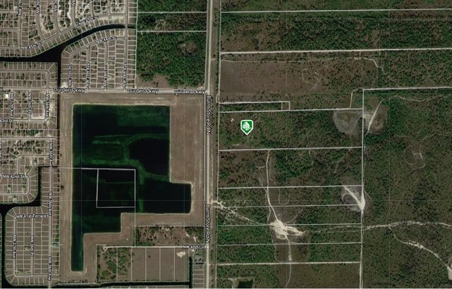
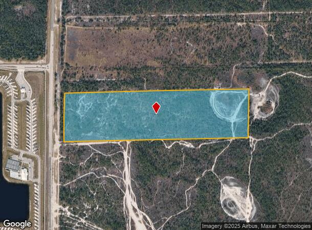
Burnt Store Rd N, Cape Coral, FL 33993
NEARBY LISTINGS FOR SALE OR LEASE
Property Detail
Burnt Store Rd N
Cape Coral-Fort Myers, FL
Burnt Store East
17-43-23-00-00001.0050
S 1/2 OF N 1/2 OF NW 1/4 LESS RD R/W
Miscellaneous
Lee
X
Florida
12071C0231G
3&4
2024
38.61 AC
2025
Cape Coral
010111
Southwest Florida
DEMOGRAPHICS near Burnt Store Rd N
1 Mile
3 Mile
5 Mile
2024 Total Population
274
8,606
31,743
2029 Population
342
10,591
38,566
Pop Growth 2024-2029
+ 24.82%
+ 23.07%
+ 21.49%
Average Age
42
52
44
2024 Total Households
99
3,639
11,707
HH Growth 2024-2029
+ 24.24%
+ 22.67%
+ 21.34%
Median Household Inc
$80,592
$88,326
$78,271
Avg Household Size
2.70
2.30
2.60
2024 Avg HH Vehicles
2.00
2.00
2.00
Median Home Value
$157,317
$298,242
$289,760
Median Year Built
2008
2003
2005
Nearby Places
Map Layers
Map Styles
 Street
 Aerial
- Restaurants
- Banks
- Shops
- Fitness
- Groceries
PUBLIC TRANSPORTATION
AIRPORT
Punta Gorda
DRIVE
WALK
Distance
Punta Gorda
22 min
14.3 mi
Southwest Florida International
DRIVE
WALK
Distance
Southwest Florida International
51 min
32.2 mi
Freight Ports
Port Manatee
DRIVE
WALK
Distance
Port Manatee
103 min
85.9 mi
SALE & LEASE HISTORY
LISTING DATE
SALE/LEASE

Sep 13, 2018
For Sale
Nov 29, 2018
For Sale
Nearby Properties
Address
Land Use
TOTAL SIZE
Lot Size
Zoning
Address
Land Use
TOTAL SIZE
Lot Size
Zoning
670.48 AC
AG-2
Address
Land Use
TOTAL SIZE
Lot Size
Zoning
9.12 AC
AG-2
Address
Land Use
TOTAL SIZE
Lot Size
Zoning
303.23 AC
AG-2
Address
Land Use
TOTAL SIZE
Lot Size
Zoning
39,997 SF
10.34 AC
RM-2
Address
Land Use
TOTAL SIZE
Lot Size
Zoning
255.79 AC
AG-2
Address
Land Use
TOTAL SIZE
Lot Size
Zoning
142.97 AC
AG-2
Address
Land Use
TOTAL SIZE
Lot Size
Zoning
113.70 AC
AG-2
Address
Land Use
TOTAL SIZE
Lot Size
Zoning
12,820 SF
118.64 AC
II
Address
Land Use
TOTAL SIZE
Lot Size
Zoning
Address
Land Use
TOTAL SIZE
Lot Size
Zoning
12,402 SF
105.60 AC
AG-2
Address
Land Use
TOTAL SIZE
Lot Size
Zoning
9,317 SF
1.42 AC
CC
Address
Land Use
TOTAL SIZE
Lot Size
Zoning
157.25 AC
AG-2
Address
Land Use
TOTAL SIZE
Lot Size
Zoning
114.94 AC
NC
Address
Land Use
TOTAL SIZE
Lot Size
Zoning
19.27 AC
AG-2
Address
Land Use
TOTAL SIZE
Lot Size
Zoning
19 AC
AG-2
Address
Land Use
TOTAL SIZE
Lot Size
Zoning
3.71 AC
R1-W
Address
Land Use
TOTAL SIZE
Lot Size
Zoning
102.92 AC
A
Address
Land Use
TOTAL SIZE
Lot Size
Zoning
7,980 SF
54.01 AC
RE1
Address
Land Use
TOTAL SIZE
Lot Size
Zoning
38.49 AC
AG-2
Address
Land Use
TOTAL SIZE
Lot Size
Zoning
20.24 AC
AG-2
Address
Land Use
TOTAL SIZE
Lot Size
Zoning
38.54 AC
AG-2
Address
Land Use
TOTAL SIZE
Lot Size
Zoning
6,613 SF
1.18 AC
RD-W
Address
Land Use
TOTAL SIZE
Lot Size
Zoning
9.31 AC
RE
Address
Land Use
TOTAL SIZE
Lot Size
Zoning
8,247 SF
40.31 AC
RE1
Address
Land Use
TOTAL SIZE
Lot Size
Zoning
0.36 AC
RM-2
Address
Land Use
TOTAL SIZE
Lot Size
Zoning
6,991 SF
1.29 AC
RM-2
Address
Land Use
TOTAL SIZE
Lot Size
Zoning
74.85 AC
R1A
Address
Land Use
TOTAL SIZE
Lot Size
Zoning
8,929 SF
0.46 AC
R1
Address
Land Use
TOTAL SIZE
Lot Size
Zoning
Address
Land Use
TOTAL SIZE
Lot Size
Zoning
192.72 AC
NZ
The World's #1 Commercial Real Estate Marketplace
Connect with us
© 2026 CoStar Group
The information above has been obtained from sources believed reliable. While we do not doubt its accuracy we have not verified it and make no guarantee, warranty or representation about it. It is your responsibility to independently confirm its accuracy and completeness. Any projections, opinions, assumptions, or estimates used are for example only and do not represent the current or future performance of the property. The value of this transaction to you depends on tax and other factors which should be evaluated by your tax, financial, and legal advisors. You and your advisors should conduct a careful, independent investigation of the property to determine to your satisfaction the suitability of the property for your needs.