Property Record
Cairo Rd, Thomasville, GA 31792


NEARBY LISTINGS FOR SALE OR LEASE
-
-
View all Thomasville listings for sale on LoopNet.com
Property Detail
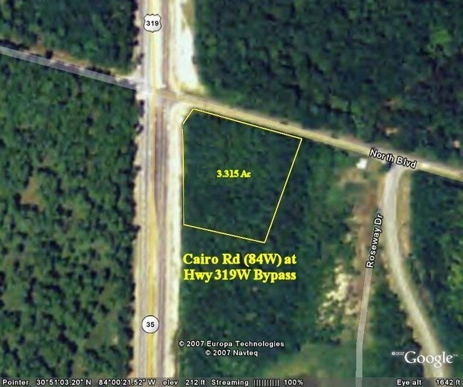
Cairo Rd
Thomasville, GA
3.32 AC/CAIRO RD @ BYPASS
056-TH-051-A
Thomas
Commercialacreage
Georgia
AE
9
13275C0207D
3.32 AC
2024
Albany/Southwest
2024
Other Market Areas
960800
DEMOGRAPHICS near Cairo Rd
1 Mile
3 Mile
5 Mile
2024 Total Population
1,952
17,943
28,916
2029 Population
1,953
18,071
28,998
Pop Growth 2024-2029
+ 0.05%
+ 0.71%
+ 0.28%
Average Age
35
40
40
2024 Total Households
763
7,416
11,808
HH Growth 2024-2029
+ 0.13%
+ 0.76%
+ 0.29%
Median Household Inc
$31,335
$44,651
$53,266
Avg Household Size
2.40
2.30
2.40
2024 Avg HH Vehicles
1.00
2.00
2.00
Median Home Value
$128,350
$157,901
$180,282
Median Year Built
1985
1977
1983
Nearby Places
Map Layers
Map Styles
 Street
 Aerial
- Restaurants
- Banks
- Shops
- Fitness
- Groceries
SALE & LEASE HISTORY
LISTING DATE
SALE/LEASE

Sep 24, 2016
For Sale
Oct 14, 2018
For Sale
Nov 15, 2018
For Sale
Nearby Properties
Address
Land Use
TOTAL SIZE
Lot Size
Zoning
Address
Land Use
TOTAL SIZE
Lot Size
Zoning
178,227 SF
16.73 AC
C-1
Address
Land Use
TOTAL SIZE
Lot Size
Zoning
327,147 SF
106.07 AC
AG
Address
Land Use
TOTAL SIZE
Lot Size
Zoning
271,000 SF
95.80 AC
R1
Address
Land Use
TOTAL SIZE
Lot Size
Zoning
117,638 SF
1.89 AC
C-2
Address
Land Use
TOTAL SIZE
Lot Size
Zoning
16,104 SF
48 AC
M
Address
Land Use
TOTAL SIZE
Lot Size
Zoning
72,404 SF
3.79 AC
C-2
Address
Land Use
TOTAL SIZE
Lot Size
Zoning
12,265 SF
39.66 AC
AG
Address
Land Use
TOTAL SIZE
Lot Size
Zoning
145,231 SF
13.95 AC
M
Address
Land Use
TOTAL SIZE
Lot Size
Zoning
37,211 SF
4.55 AC
C-1-LU
Address
Land Use
TOTAL SIZE
Lot Size
Zoning
83,919 SF
24.59 AC
R-1A
Address
Land Use
TOTAL SIZE
Lot Size
Zoning
40,922 SF
9.80 AC
AG
Address
Land Use
TOTAL SIZE
Lot Size
Zoning
273,600 SF
24.99 AC
M
Address
Land Use
TOTAL SIZE
Lot Size
Zoning
67,454 SF
31.60 AC
R-2
Address
Land Use
TOTAL SIZE
Lot Size
Zoning
1,560 SF
23.96 AC
M
Address
Land Use
TOTAL SIZE
Lot Size
Zoning
44,801 SF
3.97 AC
C-2
Address
Land Use
TOTAL SIZE
Lot Size
Zoning
12,650 SF
11.68 AC
M
Address
Land Use
TOTAL SIZE
Lot Size
Zoning
150,000 SF
27.32 AC
M
Address
Land Use
TOTAL SIZE
Lot Size
Zoning
57,600 SF
8.30 AC
R-TH
Address
Land Use
TOTAL SIZE
Lot Size
Zoning
600 SF
80.09 AC
M
Address
Land Use
TOTAL SIZE
Lot Size
Zoning
22,048 SF
8.32 AC
M
Address
Land Use
TOTAL SIZE
Lot Size
Zoning
37,512 SF
7.53 AC
R-2
Address
Land Use
TOTAL SIZE
Lot Size
Zoning
33,002 SF
35.89 AC
R-1
Address
Land Use
TOTAL SIZE
Lot Size
Zoning
36,396 SF
2 AC
C1
Address
Land Use
TOTAL SIZE
Lot Size
Zoning
64,768 SF
4.70 AC
M/C-1-LU
Address
Land Use
TOTAL SIZE
Lot Size
Zoning
110,795 SF
8.50 AC
M
Address
Land Use
TOTAL SIZE
Lot Size
Zoning
21,233 SF
1.11 AC
C-2
Address
Land Use
TOTAL SIZE
Lot Size
Zoning
20,846 SF
6 AC
C-2
Address
Land Use
TOTAL SIZE
Lot Size
Zoning
7,680 SF
14.96 AC
R-TH
Address
Land Use
TOTAL SIZE
Lot Size
Zoning
14,336 SF
1.67 AC
C-2
Address
Land Use
TOTAL SIZE
Lot Size
Zoning
39,320 SF
0.74 AC
C-2
The World's #1 Commercial Real Estate Marketplace
Connect with us
© 2026 CoStar Group
The information above has been obtained from sources believed reliable. While we do not doubt its accuracy we have not verified it and make no guarantee, warranty or representation about it. It is your responsibility to independently confirm its accuracy and completeness. Any projections, opinions, assumptions, or estimates used are for example only and do not represent the current or future performance of the property. The value of this transaction to you depends on tax and other factors which should be evaluated by your tax, financial, and legal advisors. You and your advisors should conduct a careful, independent investigation of the property to determine to your satisfaction the suitability of the property for your needs.