Property Record
Byron Rd, Zeeland, MI 49464

NEARBY LISTINGS FOR SALE OR LEASE
-
-
View all Zeeland listings for sale on LoopNet.com
Property Detail
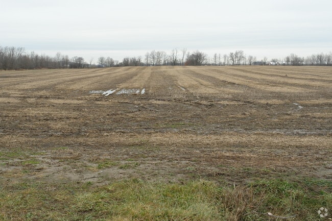
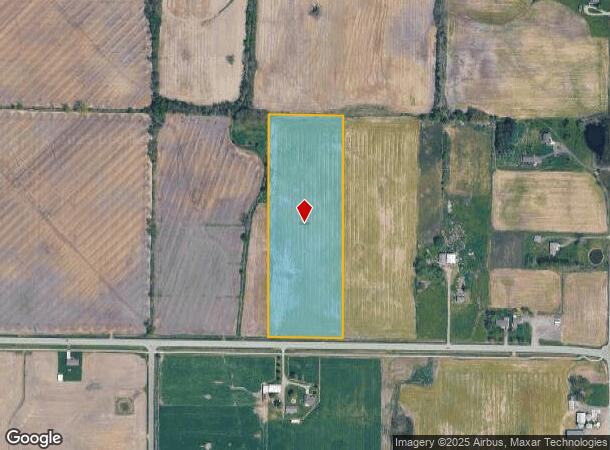
Byron Rd
70-17-13-400-031
PART OF SE 1/4 COM 156014 FT W OF SE SEC COR, TH W 429 FT, N 0D 35M 53S W 132337 FT, N 89D 58M 23S E 429 FT, TH S 0D 35M 53S
Agriculturalland
Ottawa
X
Michigan
26005C0075G
12.70 AC
2024
E Ottawa Cnty/Hudsonville
2025
West Michigan
022900
Grand Rapids-Wyoming, MI
DEMOGRAPHICS near Byron Rd
1 Mile
3 Mile
5 Mile
2024 Total Population
202
5,232
27,143
2029 Population
205
5,492
28,482
Pop Growth 2024-2029
+ 1.49%
+ 4.97%
+ 4.93%
Average Age
33
35
36
2024 Total Households
62
1,655
9,101
HH Growth 2024-2029
+ 1.61%
+ 5.14%
+ 5.02%
Median Household Inc
$95,833
$95,708
$92,209
Avg Household Size
3.20
3.10
2.90
2024 Avg HH Vehicles
2.00
2.00
2.00
Median Home Value
$328,947
$315,590
$281,583
Median Year Built
1948
1993
1995
Nearby Places
Map Layers
Map Styles
 Street
 Aerial
- Restaurants
- Banks
- Shops
- Fitness
- Groceries
PUBLIC TRANSPORTATION
AIRPORT
Gerald R Ford International
DRIVE
WALK
Distance
Gerald R Ford International
34 min
25.0 mi
Freight Ports
Port Milwaukee
DRIVE
WALK
Distance
Port Milwaukee
287 min
245.3 mi
Nearby Properties
Address
Land Use
TOTAL SIZE
Lot Size
Zoning
Address
Land Use
TOTAL SIZE
Lot Size
Zoning
273,515 SF
Address
Land Use
TOTAL SIZE
Lot Size
Zoning
392,381 SF
21.73 AC
SEE MAP
Address
Land Use
TOTAL SIZE
Lot Size
Zoning
85,799 SF
12.89 AC
SEE MAP
Address
Land Use
TOTAL SIZE
Lot Size
Zoning
138,648 SF
Address
Land Use
TOTAL SIZE
Lot Size
Zoning
162,719 SF
19.77 AC
SEE MAP
Address
Land Use
TOTAL SIZE
Lot Size
Zoning
12,156 SF
180.91 AC
AG
Address
Land Use
TOTAL SIZE
Lot Size
Zoning
6.29 AC
SEE MAP
Address
Land Use
TOTAL SIZE
Lot Size
Zoning
91,450 SF
10.45 AC
SEE MAP
Address
Land Use
TOTAL SIZE
Lot Size
Zoning
0.50 AC
Address
Land Use
TOTAL SIZE
Lot Size
Zoning
50,578 SF
31.51 AC
SEE MAP
Address
Land Use
TOTAL SIZE
Lot Size
Zoning
32,400 SF
67.30 AC
SEE MAP
Address
Land Use
TOTAL SIZE
Lot Size
Zoning
42,914 SF
4.04 AC
SEE MAP
Address
Land Use
TOTAL SIZE
Lot Size
Zoning
162,816 SF
18.93 AC
SEE MAP
Address
Land Use
TOTAL SIZE
Lot Size
Zoning
62,589 SF
16.47 AC
SEE MAP
Address
Land Use
TOTAL SIZE
Lot Size
Zoning
1,448 SF
40.81 AC
SEE MAP
Address
Land Use
TOTAL SIZE
Lot Size
Zoning
1,589 SF
77.43 AC
AG
Address
Land Use
TOTAL SIZE
Lot Size
Zoning
33.47 AC
AG
Address
Land Use
TOTAL SIZE
Lot Size
Zoning
40,225 SF
14.07 AC
SEE MAP
Address
Land Use
TOTAL SIZE
Lot Size
Zoning
64.63 AC
SEE MAP
Address
Land Use
TOTAL SIZE
Lot Size
Zoning
68,000 SF
Address
Land Use
TOTAL SIZE
Lot Size
Zoning
180,000 SF
11.51 AC
R-1
Address
Land Use
TOTAL SIZE
Lot Size
Zoning
49,116 SF
8.25 AC
SEE MAP
Address
Land Use
TOTAL SIZE
Lot Size
Zoning
11,375 SF
1.92 AC
SEE MAP
Address
Land Use
TOTAL SIZE
Lot Size
Zoning
Address
Land Use
TOTAL SIZE
Lot Size
Zoning
78.89 AC
SEE MAP
Address
Land Use
TOTAL SIZE
Lot Size
Zoning
26,600 SF
Address
Land Use
TOTAL SIZE
Lot Size
Zoning
48,859 SF
4.41 AC
SEE MAP
Address
Land Use
TOTAL SIZE
Lot Size
Zoning
11,432 SF
2.52 AC
SEE MAP
Address
Land Use
TOTAL SIZE
Lot Size
Zoning
39,360 SF
5.55 AC
AG
Address
Land Use
TOTAL SIZE
Lot Size
Zoning
52,690 SF
The World's #1 Commercial Real Estate Marketplace
Connect with us
© 2025 CoStar Group
The information above has been obtained from sources believed reliable. While we do not doubt its accuracy we have not verified it and make no guarantee, warranty or representation about it. It is your responsibility to independently confirm its accuracy and completeness. Any projections, opinions, assumptions, or estimates used are for example only and do not represent the current or future performance of the property. The value of this transaction to you depends on tax and other factors which should be evaluated by your tax, financial, and legal advisors. You and your advisors should conduct a careful, independent investigation of the property to determine to your satisfaction the suitability of the property for your needs.